
| Memorials | : | 0 |
| Location | : | Egmond aan den Hoef, Bergen Municipality, Netherlands |
| Coordinate | : | 52.5950000, 4.6602780 |
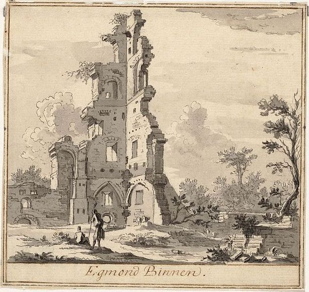
| Description | : | Egmond Abbey or St. Adalbert's Abbey is a Benedictine monastery between Egmond aan den Hoef and Bakkum in Egmond-Binnen in the municipality of Bergen in the Dutch province of North Holland. Founded in 975 and destroyed in the Reformation, it was re-founded in 1935 as the present Sint-Adelbertabdij, under the Diocese of Haarlem. The Benedictine abbey was founded by Dirk I, Count of Holland, apparently in about 920-925, as a nunnery that, according to local tradition, had been there since Saints Adalbert and Willibrord landed in 760. In about 950 work began on a stone church to replace by the wooden... Read More |
frequently asked questions (FAQ):
-
Where is Egmond Abbey?
Egmond Abbey is located at Egmond aan den Hoef, Bergen Municipality ,Noord-Holland ,Netherlands.
-
Egmond Abbey cemetery's updated grave count on graveviews.com?
0 memorials
-
Where are the coordinates of the Egmond Abbey?
Latitude: 52.5950000
Longitude: 4.6602780

Nearby Cemetories:
1. RK Begraafplaats Willibrordushof
Heiloo, Heiloo Municipality, Netherlands
Coordinate: 52.5999540, 4.6975590
2. Algemene Begraafsplaats Holleweg
Heiloo, Heiloo Municipality, Netherlands
Coordinate: 52.6026850, 4.7044120
3. Egmond aan Zee Algemene Begraafplaats
Egmond aan Zee, Bergen Municipality, Netherlands
Coordinate: 52.6189449, 4.6337843
4. Witte Kerk Cemetery
Heiloo, Heiloo Municipality, Netherlands
Coordinate: 52.6049130, 4.7128400
5. Limmen Protestant Churchyard
Limmen, Castricum Municipality, Netherlands
Coordinate: 52.5716780, 4.7007150
6. Sint-Pancratiuskerkhof
Castricum, Castricum Municipality, Netherlands
Coordinate: 52.5476200, 4.6685500
7. Castricum Protestant Cemetery
Castricum, Castricum Municipality, Netherlands
Coordinate: 52.5463500, 4.6637700
8. Joodse Begraafplaats
Alkmaar Municipality, Netherlands
Coordinate: 52.6255000, 4.7279200
9. Alkmaar Sint-Barbara Roman Catholic Cemetery
Alkmaar, Alkmaar Municipality, Netherlands
Coordinate: 52.6243500, 4.7318460
10. Alkmaar Algemene Begraafplaats
Alkmaar, Alkmaar Municipality, Netherlands
Coordinate: 52.6277500, 4.7302600
11. Begraafplaats Protestantse Gemeente
Akersloot, Castricum Municipality, Netherlands
Coordinate: 52.5608010, 4.7296890
12. Overtuin Begraafsplaats
Akersloot, Castricum Municipality, Netherlands
Coordinate: 52.5617700, 4.7374500
13. Grote Sint Laurenskerk
Alkmaar, Alkmaar Municipality, Netherlands
Coordinate: 52.6325150, 4.7440124
14. Rooms Katholieke begraafplaats
Uitgeest, Uitgeest Municipality, Netherlands
Coordinate: 52.5266880, 4.7151508
15. Ruinekerk
Bergen, Bergen Municipality, Netherlands
Coordinate: 52.6703450, 4.7054100
16. Heemskerk Protestant Churchyard
Heemskerk, Heemskerk Municipality, Netherlands
Coordinate: 52.5103100, 4.6711700
17. Bergen General Cemetery
Bergen, Bergen Municipality, Netherlands
Coordinate: 52.6772500, 4.7098600
18. Stompetoren Churchyard
Stompetoren, Alkmaar Municipality, Netherlands
Coordinate: 52.6115300, 4.8197300
19. Beverwijk General Cemetery
Beverwijk, Beverwijk Municipality, Netherlands
Coordinate: 52.4932300, 4.6370000
20. Wijk aan zee Protestant Cemetery
Wijk aan Zee, Beverwijk Municipality, Netherlands
Coordinate: 52.4920400, 4.5913800
21. Algemene Begraafplaats
Krommenie, Zaanstad Municipality, Netherlands
Coordinate: 52.5046800, 4.7675600
22. Schoorl General Cemetery
Schoorl, Bergen Municipality, Netherlands
Coordinate: 52.7060800, 4.6981500
23. Wormerveer-West Algemene Begraafplaats
Wormerveer, Zaanstad Municipality, Netherlands
Coordinate: 52.4938340, 4.7864340
24. Ijmuiden Western Cemetery
IJmuiden, Velsen Municipality, Netherlands
Coordinate: 52.4593400, 4.6000500