
| Memorials | : | 0 |
| Location | : | Bergen, Bergen Municipality, Netherlands |
| Coordinate | : | 52.6703450, 4.7054100 |
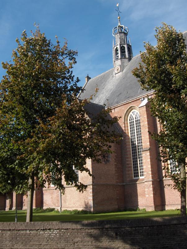
| Description | : | The church was built in the 15th century. In 1574, during the Eighty Years' War with Spain it was plundered and burnt down. Later, it was partly rebuilt. Between 1955 and 1961 it was restored. Behind an oak wood gate is the vault where several descendants of Prince Maurice and in-laws were buried. The grave of Count Wigbold Adriaan is the only one which was preserved. |
frequently asked questions (FAQ):
-
Where is Ruinekerk?
Ruinekerk is located at Bergen, Bergen Municipality ,Limburg ,Netherlands.
-
Ruinekerk cemetery's updated grave count on graveviews.com?
0 memorials
-
Where are the coordinates of the Ruinekerk?
Latitude: 52.6703450
Longitude: 4.7054100
Nearby Cemetories:
1. Bergen General Cemetery
Bergen, Bergen Municipality, Netherlands
Coordinate: 52.6772500, 4.7098600
2. Schoorl General Cemetery
Schoorl, Bergen Municipality, Netherlands
Coordinate: 52.7060800, 4.6981500
3. Grote Sint Laurenskerk
Alkmaar, Alkmaar Municipality, Netherlands
Coordinate: 52.6325150, 4.7440124
4. Alkmaar Algemene Begraafplaats
Alkmaar, Alkmaar Municipality, Netherlands
Coordinate: 52.6277500, 4.7302600
5. Joodse Begraafplaats
Alkmaar Municipality, Netherlands
Coordinate: 52.6255000, 4.7279200
6. Alkmaar Sint-Barbara Roman Catholic Cemetery
Alkmaar, Alkmaar Municipality, Netherlands
Coordinate: 52.6243500, 4.7318460
7. Witte Kerk Cemetery
Heiloo, Heiloo Municipality, Netherlands
Coordinate: 52.6049130, 4.7128400
8. Egmond aan Zee Algemene Begraafplaats
Egmond aan Zee, Bergen Municipality, Netherlands
Coordinate: 52.6189449, 4.6337843
9. Algemene Begraafsplaats Holleweg
Heiloo, Heiloo Municipality, Netherlands
Coordinate: 52.6026850, 4.7044120
10. RK Begraafplaats Willibrordushof
Heiloo, Heiloo Municipality, Netherlands
Coordinate: 52.5999540, 4.6975590
11. Egmond Abbey
Egmond aan den Hoef, Bergen Municipality, Netherlands
Coordinate: 52.5950000, 4.6602780
12. Stompetoren Churchyard
Stompetoren, Alkmaar Municipality, Netherlands
Coordinate: 52.6115300, 4.8197300
13. Limmen Protestant Churchyard
Limmen, Castricum Municipality, Netherlands
Coordinate: 52.5716780, 4.7007150
14. Nieuwe Algemene Begraafplaats
Sint Maarten, Schagen Municipality, Netherlands
Coordinate: 52.7691500, 4.7489600
15. Oude Algemene Begraafplaats
Sint Maarten, Schagen Municipality, Netherlands
Coordinate: 52.7743800, 4.7428100
16. Overtuin Begraafsplaats
Akersloot, Castricum Municipality, Netherlands
Coordinate: 52.5617700, 4.7374500
17. Begraafplaats Protestantse Gemeente
Akersloot, Castricum Municipality, Netherlands
Coordinate: 52.5608010, 4.7296890
18. Veenhuizen Churchyard
Veenhuizen, Heerhugowaard Municipality, Netherlands
Coordinate: 52.7027900, 4.8905700
19. Rooms Katholieke Begraafplaats
Ursem, Koggenland Municipality, Netherlands
Coordinate: 52.6267350, 4.8897360
20. Sint-Pancratiuskerkhof
Castricum, Castricum Municipality, Netherlands
Coordinate: 52.5476200, 4.6685500
21. Castricum Protestant Cemetery
Castricum, Castricum Municipality, Netherlands
Coordinate: 52.5463500, 4.6637700
22. Begraafplaats de Hoep
Schagen, Schagen Municipality, Netherlands
Coordinate: 52.7874920, 4.8065280
23. Westerbegraafplaats
Barsingerhorn, Hollands Kroon Municipality, Netherlands
Coordinate: 52.7849938, 4.8340670
24. Rooms Katholieke begraafplaats
Uitgeest, Uitgeest Municipality, Netherlands
Coordinate: 52.5266880, 4.7151508