
| Memorials | : | 0 |
| Location | : | Grape Grove Township, Ray County, USA |
| Coordinate | : | 39.5015259, -93.8108826 |
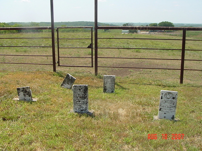
| Description | : | West of Tinney Grove on "A" Highway. There is a large field with horses on the curve. Locate the gate that is about 1/4 mile east of the curve. Walk down the outside of the electric fence on the east side. The cemetery is located about 350 yards from the road. There is a large stone with several bars around it. There are about 5 gravestones. The owner has mowed and maintained the area. Shawn Coats property. The man that showed me this cemetery says that Elder's are buried here and another brother was buried over in Carroll County. He... Read More |
frequently asked questions (FAQ):
-
Where is Elder Cemetery?
Elder Cemetery is located at Grape Grove Township, Ray County ,Missouri ,USA.
-
Elder Cemetery cemetery's updated grave count on graveviews.com?
0 memorials
-
Where are the coordinates of the Elder Cemetery?
Latitude: 39.5015259
Longitude: -93.8108826
Nearby Cemetories:
1. Tinney Grove Cemetery
Tinney Grove, Ray County, USA
Coordinate: 39.5066280, -93.8050000
2. Graff Cemetery
Grape Grove Township, Ray County, USA
Coordinate: 39.4909286, -93.8144836
3. Little Union Cemetery
Stet, Ray County, USA
Coordinate: 39.4972343, -93.8660507
4. McBee Chapel Cemetery
Carroll County, USA
Coordinate: 39.5239983, -93.7559967
5. Black Oak Cemetery
Braymer, Caldwell County, USA
Coordinate: 39.5469017, -93.8403473
6. Basham Cemetery
Ray County, USA
Coordinate: 39.4963400, -93.8810700
7. Silas Keith Cemetery
Regal, Ray County, USA
Coordinate: 39.4387800, -93.8262100
8. Tevalt-Northern Sympathizers Cemetery
Carroll County, USA
Coordinate: 39.4593010, -93.7379990
9. McCuistion Cemetery
Richmond, Ray County, USA
Coordinate: 39.4387300, -93.8550900
10. Old New Hope Cemetery
Millville, Ray County, USA
Coordinate: 39.4327200, -93.8435900
11. Oster Cemetery
Caldwell County, USA
Coordinate: 39.5684400, -93.7622100
12. Bethany Church Cemetery
Stet, Ray County, USA
Coordinate: 39.4230995, -93.7838974
13. New Hope United Methodist Church Cemetery
Millville, Ray County, USA
Coordinate: 39.4236259, -93.8416061
14. Mount Olivet Cemetery
Stet, Carroll County, USA
Coordinate: 39.4366000, -93.7403000
15. Low Gap Cemetery
Norborne, Carroll County, USA
Coordinate: 39.5244000, -93.7024000
16. Antioch Cemetery
Millville, Ray County, USA
Coordinate: 39.4563040, -93.9077420
17. Van Wall Cemetery
Grape Grove Township, Ray County, USA
Coordinate: 39.4513800, -93.9116700
18. Mansur Cemetery
Grape Grove Township, Ray County, USA
Coordinate: 39.4230003, -93.8804016
19. Petree Cemetery
Taitsville, Ray County, USA
Coordinate: 39.4781700, -93.9315100
20. Evergreen Cemetery
Braymer, Caldwell County, USA
Coordinate: 39.5986290, -93.7981720
21. Yoakum Cemetery
Richmond, Ray County, USA
Coordinate: 39.4909100, -93.9380500
22. Felix Wild Cemetery
Ray County, USA
Coordinate: 39.4398200, -93.9110700
23. Union Baptist Church Cemetery
Roads, Carroll County, USA
Coordinate: 39.4486008, -93.7021027
24. Cowgill Cemetery
Cowgill, Caldwell County, USA
Coordinate: 39.5531311, -93.9222488