
| Memorials | : | 2 |
| Location | : | Cull, Howell County, USA |
| Coordinate | : | 36.7450600, -91.6929245 |
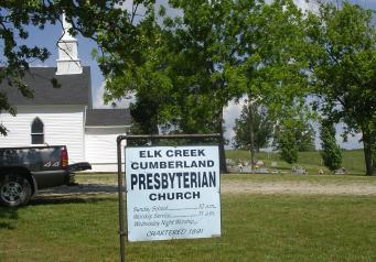
| Description | : | Located behind Elk Creek Cumberland Presbyterian Church. 10 miles East of West Plains, MO on HWY 160 South on CR 9830, 1/2 mile. |
frequently asked questions (FAQ):
-
Where is Elk Creek Cemetery?
Elk Creek Cemetery is located at Cull, Howell County ,Missouri ,USA.
-
Elk Creek Cemetery cemetery's updated grave count on graveviews.com?
2 memorials
-
Where are the coordinates of the Elk Creek Cemetery?
Latitude: 36.7450600
Longitude: -91.6929245
Nearby Cemetories:
1. Francis Cemetery
Cull, Howell County, USA
Coordinate: 36.7299995, -91.6789017
2. Jim Willard Farm
Rover, Oregon County, USA
Coordinate: 36.7311100, -91.6496200
3. Aikens Family Cemetery
Rover, Oregon County, USA
Coordinate: 36.7437200, -91.6285500
4. Bennett Chapel Cemetery
Fanchon, Howell County, USA
Coordinate: 36.8025589, -91.7312546
5. Barnett Cemetery
West Plains, Howell County, USA
Coordinate: 36.7871476, -91.7582962
6. Barnett Cemetery
Peace Valley, Howell County, USA
Coordinate: 36.7874500, -91.7595020
7. Redburn Cemetery
Rover, Oregon County, USA
Coordinate: 36.7174988, -91.6066971
8. Jolliff Cemetery
Rover, Oregon County, USA
Coordinate: 36.7430992, -91.5892029
9. Howell Valley Cemetery
West Plains, Howell County, USA
Coordinate: 36.7144012, -91.7953033
10. Chapin Cemetery
West Plains, Howell County, USA
Coordinate: 36.6781006, -91.7683029
11. Brandsville Cemetery
Brandsville, Howell County, USA
Coordinate: 36.6506195, -91.6873856
12. New Hope Cemetery
Peace Valley, Howell County, USA
Coordinate: 36.8303337, -91.7540359
13. Bridges Cemetery
Koshkonong, Oregon County, USA
Coordinate: 36.6495209, -91.6409683
14. Thomasville Civil War Cemetery #2
Thomasville, Oregon County, USA
Coordinate: 36.7814100, -91.5606600
15. County Farm Cemetery
Chapin, Howell County, USA
Coordinate: 36.6831017, -91.8097000
16. Howell County Rural Cemetery
Mountain View, Howell County, USA
Coordinate: 36.6831100, -91.8098600
17. Pleasant View Cemetery
West Plains, Howell County, USA
Coordinate: 36.7900009, -91.8257980
18. Oak Lawn Cemetery
West Plains, Howell County, USA
Coordinate: 36.7235985, -91.8419037
19. Union Hill Cemetery
Thomasville, Oregon County, USA
Coordinate: 36.7468987, -91.5346985
20. Lane Cemetery
Oregon County, USA
Coordinate: 36.7881012, -91.5410995
21. Bellah Cemetery
Thomasville, Oregon County, USA
Coordinate: 36.7881012, -91.5406036
22. Saint Joseph Cemetery
White Church, Howell County, USA
Coordinate: 36.8517100, -91.7876100
23. Thomasville Civil War Cemetery
Thomasville, Oregon County, USA
Coordinate: 36.7845800, -91.5301100
24. Woodside Cemetery
Thomasville, Oregon County, USA
Coordinate: 36.7927017, -91.5317993