
| Memorials | : | 1 |
| Location | : | Woodlandville, Boone County, USA |
| Coordinate | : | 39.0615160, -92.4631690 |
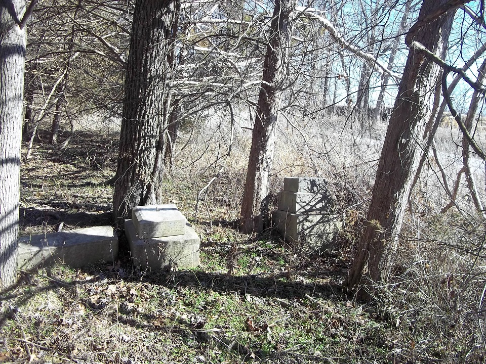
| Description | : | One mile east of Woodlandville - Off the north side of Wilhite Road, between Evert School Rd and Bell Rd. Very few stones remain and no signs of the original church building. It is our understanding that the land-owner has haulled away the rest of the headstones. On September 2, 1859 the Methodists from Bethlehem Church (Woodlandville) reorganized and were deeded 5 acres of land in the town of Everett for church purposes. Here they built a frame church building, there were three plain glass windows in the north and south walls and the door in the front facing west. A... Read More |
frequently asked questions (FAQ):
-
Where is Evert Church Cemetery?
Evert Church Cemetery is located at Woodlandville, Boone County ,Missouri ,USA.
-
Evert Church Cemetery cemetery's updated grave count on graveviews.com?
1 memorials
-
Where are the coordinates of the Evert Church Cemetery?
Latitude: 39.0615160
Longitude: -92.4631690
Nearby Cemetories:
1. Cowden Family Cemetery
Woodlandville, Boone County, USA
Coordinate: 39.0598300, -92.4919100
2. Bethlehem Cemetery
Harrisburg, Boone County, USA
Coordinate: 39.0965290, -92.4516360
3. Taylor Family Cemetery
Columbia, Boone County, USA
Coordinate: 39.0392600, -92.4094900
4. Old Bethel Cemetery
Midway, Boone County, USA
Coordinate: 39.0414200, -92.5198800
5. Smith Chapel Church Cemetery
Fayette, Howard County, USA
Coordinate: 39.0897590, -92.5187931
6. Lientz Cemetery
Midway, Boone County, USA
Coordinate: 39.0080400, -92.5050200
7. Red Rock Cemetery
Harrisburg, Boone County, USA
Coordinate: 39.1059400, -92.4015400
8. Botner Cemetery
Boone County, USA
Coordinate: 39.0800018, -92.3816986
9. Walnut Grove Cemetery
Rocheport, Boone County, USA
Coordinate: 39.0125008, -92.5233002
10. New Providence Cemetery
Columbia, Boone County, USA
Coordinate: 39.0071500, -92.4019100
11. Big Springs Christian Church Cemetery
Hilldale, Howard County, USA
Coordinate: 39.0328598, -92.5495834
12. Dripping Spring Christian Church Cemetery
Columbia, Boone County, USA
Coordinate: 39.0870200, -92.3747400
13. Barnes Cemetery
Howard County, USA
Coordinate: 39.1268997, -92.5093994
14. Boone County Graveyard
Boone County, USA
Coordinate: 39.1383160, -92.4631690
15. Locust Grove Cemetery
Midway, Boone County, USA
Coordinate: 38.9855120, -92.4485580
16. Hourigan Cemetery
Howard County, USA
Coordinate: 39.0558014, -92.5622025
17. Mount Woodland African Methodist Episcopal Church
Hilldale, Howard County, USA
Coordinate: 39.0601980, -92.5632510
18. Harrisburg Cemetery
Harrisburg, Boone County, USA
Coordinate: 39.1413400, -92.4553200
19. Searcy Cemetery
Hinton, Boone County, USA
Coordinate: 39.0793915, -92.3542633
20. Cochran Family Cemetery
Boone County, USA
Coordinate: 38.9724560, -92.4861290
21. Rocky Fork Baptist Church Cemetery
Hinton, Boone County, USA
Coordinate: 39.0536308, -92.3411484
22. Givens Cemetery
Howard County, USA
Coordinate: 39.1399994, -92.5378036
23. Rural Jordan Cemetery
Rocheport, Boone County, USA
Coordinate: 38.9626376, -92.4810337
24. Wade Cemetery
Hinton, Boone County, USA
Coordinate: 39.0648003, -92.3293686