
| Memorials | : | 0 |
| Location | : | Pettis County, USA |
| Coordinate | : | 38.5236015, -93.3638992 |
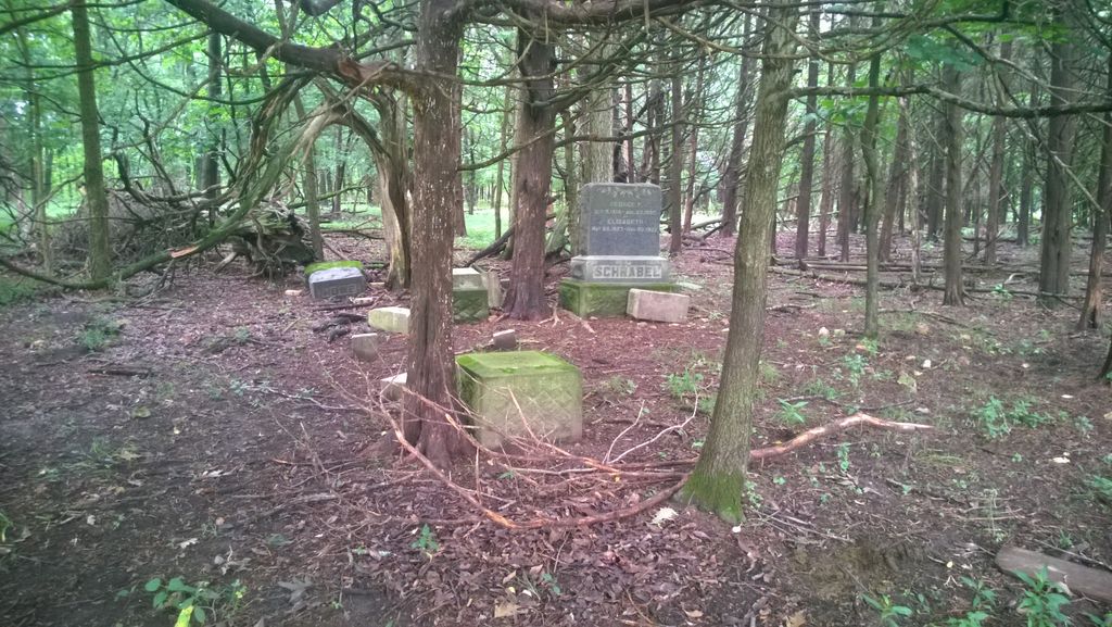
| Description | : | Shown on Geo Survey map as "Methodist Cem" and listed in 1882 county history as Flat Creek Protestant Methodist congregation, the only church then in Washington Township. Long abandoned and no sign, graves visible only in winter. Remaining legible stones copied 2006 by J. C. and Carol Mahnken Should not be confused with Flat Creek Baptist Cemetery in Smithton Township SE of Sedalia Histories of this congregation conflict: A 1969 Benton County, Mo. history lists its establishment at this site 1880 as "Pleasant View" Methodist with same founding members, and move in 1906 to "New" Ionia. |
frequently asked questions (FAQ):
-
Where is Flat Creek Methodist Cemetery?
Flat Creek Methodist Cemetery is located at Pettis County ,Missouri ,USA.
-
Flat Creek Methodist Cemetery cemetery's updated grave count on graveviews.com?
0 memorials
-
Where are the coordinates of the Flat Creek Methodist Cemetery?
Latitude: 38.5236015
Longitude: -93.3638992
Nearby Cemetories:
1. Prairie Chapel Methodist Cemetery
Pettis County, USA
Coordinate: 38.5228004, -93.3818970
2. Christian Cemetery
Pettis County, USA
Coordinate: 38.5080986, -93.3371964
3. Antioch Baptist Church Cemetery
Manila, Pettis County, USA
Coordinate: 38.5526200, -93.3364600
4. Larkey Cemetery
Lincoln, Benton County, USA
Coordinate: 38.4500000, -93.3650000
5. Immanuel Lutheran Cemetery
Lincoln, Benton County, USA
Coordinate: 38.4500000, -93.3710000
6. Point Pleasant Cemetery
Green Ridge, Pettis County, USA
Coordinate: 38.5501800, -93.2717100
7. Nelson Cemetery
Washington Township, Pettis County, USA
Coordinate: 38.6106500, -93.3723300
8. Saint Johns Lutheran Cemetery
Cole Camp, Benton County, USA
Coordinate: 38.4981150, -93.2495790
9. Clover Dale-Yancy Cemetery
Benton County, USA
Coordinate: 38.4392014, -93.4191971
10. Green Ridge Cemetery
Green Ridge, Pettis County, USA
Coordinate: 38.6207100, -93.4151500
11. Mount Olivet Church Cemetery
Cole Camp, Benton County, USA
Coordinate: 38.4416900, -93.2770200
12. Kerber Family Farm Cemetery
Cole Camp, Benton County, USA
Coordinate: 38.4438200, -93.2717500
13. Bell Cemetery
Pettis County, USA
Coordinate: 38.5130997, -93.5038986
14. Harmony Baptist Church Cemetery
Benton County, USA
Coordinate: 38.4460600, -93.4643000
15. Malsy Cemetery
Lincoln, Benton County, USA
Coordinate: 38.4120600, -93.3664600
16. Lincoln Cemetery
Lincoln, Benton County, USA
Coordinate: 38.4089012, -93.3405991
17. Mitchell Cemetery
Lincoln, Benton County, USA
Coordinate: 38.4064600, -93.3595000
18. New Bethel Cemetery
Sedalia, Pettis County, USA
Coordinate: 38.6191500, -93.2669600
19. McKee Chapel Cemetery
Sedalia, Pettis County, USA
Coordinate: 38.6396100, -93.3144800
20. Laurel Oak Cemetery
Windsor, Henry County, USA
Coordinate: 38.5224991, -93.5203018
21. Cole Camp Cemetery
Cole Camp, Benton County, USA
Coordinate: 38.4594002, -93.2260971
22. Eastwood Cemetery
Cole Camp, Benton County, USA
Coordinate: 38.4624800, -93.2229600
23. Bourn Cemetery
Spring Fork, Pettis County, USA
Coordinate: 38.6119410, -93.2463310
24. McIntire Chapel Cemetery
Windsor Junction, Benton County, USA
Coordinate: 38.4303017, -93.4760971