| Memorials | : | 8 |
| Location | : | East Bergholt, Babergh District, England |
| Coordinate | : | 51.9698890, 1.0148040 |
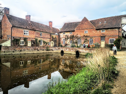
| Description | : | The history of this cemetery goes back to a property known as "Old Hall", which dates to Norman times. The property, a private residence, was put up for sale in 1849 and purchased by the Benedictine Nuns of Winchester, whose origins began in Brussels in 1598. In 1857, St Mary's Abbey was established on the site and operated as such until 1940, when the Nuns feared invasion. From 1940 to 1945 the property was occupied by the Army. In 1946, the Franciscan Friars purchased the property and began a House of Studies (St Mary's Friary) until 1973. ... Read More |
frequently asked questions (FAQ):
-
Where is Franciscan Cemetery?
Franciscan Cemetery is located at Rectory Hill East Bergholt, Babergh District ,Suffolk , CO7 6TGEngland.
-
Franciscan Cemetery cemetery's updated grave count on graveviews.com?
8 memorials
-
Where are the coordinates of the Franciscan Cemetery?
Latitude: 51.9698890
Longitude: 1.0148040
Nearby Cemetories:
1. St. Mary the Virgin Churchyard
East Bergholt, Babergh District, England
Coordinate: 51.9699760, 1.0125630
2. East Bergholt Congregational Churchyard
East Bergholt, Babergh District, England
Coordinate: 51.9716960, 1.0102980
3. East Bergholt Cemetery
East Bergholt, Babergh District, England
Coordinate: 51.9714670, 1.0086430
4. St. Mary the Virgin Churchyard
Dedham, Colchester Borough, England
Coordinate: 51.9586270, 0.9927610
5. St Mary's Churchyard
Stratford St Mary, Babergh District, England
Coordinate: 51.9718250, 0.9862600
6. St. Mary's Churchyard
Holton St Mary, Babergh District, England
Coordinate: 51.9911800, 0.9982800
7. St Bartholomew's Church
Snarestone, North West Leicestershire District, England
Coordinate: 52.0000000, 1.0000000
8. St John Church
Great Wenham (Wenham Magna), Babergh District, England
Coordinate: 52.0029360, 1.0157390
9. St Mary's Church Burial Ground
Higham, Forest Heath District, England
Coordinate: 51.9782680, 0.9626690
10. St Mary the Virgin Churchyard
Langham, Colchester Borough, England
Coordinate: 51.9644450, 0.9596300
11. St Michael the Archangel Churchyard
Brantham, Babergh District, England
Coordinate: 51.9662000, 1.0733300
12. St Mary the Virgin Churchyard
Capel St Mary, Babergh District, England
Coordinate: 52.0034690, 1.0370820
13. St. Mary Churchyard
Raydon, Babergh District, England
Coordinate: 52.0081090, 0.9847290
14. All Saints Churchyard
Little Wenham (Wenham Parva), Babergh District, England
Coordinate: 52.0119000, 1.0309000
15. Ss Mary & Michael Churchyard
Mistley, Tendring District, England
Coordinate: 51.9442000, 1.0736500
16. Mistley Towers
Mistley, Tendring District, England
Coordinate: 51.9460110, 1.0774110
17. Ardleigh Cemetery
Ardleigh, Tendring District, England
Coordinate: 51.9263900, 0.9893000
18. St Mary's Church Burial Ground - old
Bentley, Babergh District, England
Coordinate: 52.0011990, 1.0849940
19. St Mary's Church Burial Ground - new
Bentley, Babergh District, England
Coordinate: 52.0011070, 1.0862490
20. Our Lady Immaculate Withermarsh Green
Stoke by Nayland, Babergh District, England
Coordinate: 51.9950800, 0.9326260
21. St Mary the Virgin Churchyard
Little Bromley, Tendring District, England
Coordinate: 51.9095300, 1.0401700
22. St Mary Churchyard
Tattingstone, Babergh District, England
Coordinate: 51.9915530, 1.1097690
23. Tattingstone Union Workhouse
Tattingstone, Babergh District, England
Coordinate: 51.9929950, 1.1109450
24. St. Andrew's Churchyard
Layham, Babergh District, England
Coordinate: 52.0240520, 0.9580820

