
| Memorials | : | 1 |
| Location | : | Franeker, Franekeradeel Municipality, Netherlands |
| Coordinate | : | 53.1845100, 5.5330800 |
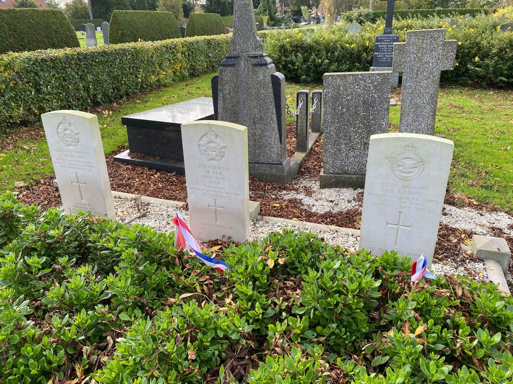
| Description | : | The small town of Franeker is 10 kilometres east of Harlingen on the Leeuwarden-Harlingen road. The cemetery is on the western outskirts of the town, in Harlingerweg next to the park. Three Commonwealth war graves are in the centre of the cemetery next to a large tree. One of the fallen soldiers is unknown. |
frequently asked questions (FAQ):
-
Where is Franeker General Cemetery?
Franeker General Cemetery is located at Franeker, Franekeradeel Municipality ,Friesland ,Netherlands.
-
Franeker General Cemetery cemetery's updated grave count on graveviews.com?
1 memorials
-
Where are the coordinates of the Franeker General Cemetery?
Latitude: 53.1845100
Longitude: 5.5330800
Nearby Cemetories:
1. Nederlands hervormde Kerk Herbaijum
Herbaijum, Franekeradeel Municipality, Netherlands
Coordinate: 53.1849700, 5.4952100
2. Johanneskerk - Protestantse Gemeente Tzum
Tzum, Franekeradeel Municipality, Netherlands
Coordinate: 53.1589801, 5.5629124
3. Sint Gertrudistsjerke
Peins, Franekeradeel Municipality, Netherlands
Coordinate: 53.2059212, 5.5950833
4. Oosterbierum Kerkhof
Oosterbierum, Franekeradeel Municipality, Netherlands
Coordinate: 53.2340554, 5.5108091
5. Walburgatsjerke
Ried, Franekeradeel Municipality, Netherlands
Coordinate: 53.2231866, 5.5900183
6. Kerkhof Sint Martinuskerk
Tzummarum, Franekeradeel Municipality, Netherlands
Coordinate: 53.2365670, 5.5436750
7. Stevenskerk kerkhof
Skingen, Menaldumadeel Municipality, Netherlands
Coordinate: 53.2022626, 5.6179534
8. Dionysiustsjerke
Slappeterp, Menaldumadeel Municipality, Netherlands
Coordinate: 53.2136468, 5.6199275
9. Harlingen Roman Catholic cemetery
Harlingen, Harlingen Municipality, Netherlands
Coordinate: 53.1720500, 5.4299800
10. Harlingen General Cemetery
Harlingen, Harlingen Municipality, Netherlands
Coordinate: 53.1780100, 5.4245900
11. Tsjerkhôf Furdgum
Firdgum, Franekeradeel Municipality, Netherlands
Coordinate: 53.2484501, 5.5596364
12. Kerkhof Salviuskerk / 'd Alde Wite
Dronrijp, Menaldumadeel Municipality, Netherlands
Coordinate: 53.1967232, 5.6435867
13. Kimswerd Protestant Churchyard
Kimswerd, Sudwest Fryslan Municipality, Netherlands
Coordinate: 53.1412800, 5.4385400
14. Minnertsga Kerkhof
Minnertsga, Het Bildt Municipality, Netherlands
Coordinate: 53.2512016, 5.5942001
15. Tsjerkhôf Menaam
Menaam, Menaldumadeel Municipality, Netherlands
Coordinate: 53.2161718, 5.6616600
16. Kerkhof
Baard, Littenseradiel Municipality, Netherlands
Coordinate: 53.1423432, 5.6684373
17. Witmarsum Protestant Churchyard
Witmarsum, Sudwest Fryslan Municipality, Netherlands
Coordinate: 53.1021800, 5.4661900
18. Sint Jacobiparochie General Cemetery
Sint Jacobiparochie, Het Bildt Municipality, Netherlands
Coordinate: 53.2684100, 5.6041100
19. Redbadtsjerke churchyard
Jorwerd, Littenseradiel Municipality, Netherlands
Coordinate: 53.1457503, 5.7113044
20. Algemene Begraafplaats
Bolsward, Sudwest Fryslan Municipality, Netherlands
Coordinate: 53.0677100, 5.5214800
21. Sint-Pontianustsjerke
Marsum, Menaldumadeel Municipality, Netherlands
Coordinate: 53.2108700, 5.7280502
22. Schillaard General Cemetery
Schillaard, Littenseradiel Municipality, Netherlands
Coordinate: 53.1237600, 5.7074600
23. Mariatsjerke
Beers, Littenseradiel Municipality, Netherlands
Coordinate: 53.1558525, 5.7329919
24. Sint-MartinusKerk
Sudwest Fryslan Municipality, Netherlands
Coordinate: 53.0900008, 5.6961870