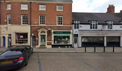
| Memorials | : | 0 |
| Location | : | Lichfield, Lichfield District, England |
| Coordinate | : | 52.6829030, -1.8282720 |
| Description | : | Grey Friars was established in c.1237 by Bishop Alexander de Stavensby and, by 1286, the construction of the friary buildings, including a chapel and dwellings, had been completed. A fire destroyed buildings at the site in 1291 and the friary was rebuilt slightly to the west of the original site. The friary was dissolved in 1538. The location is now shops with no visible headstones or churchyard. |
frequently asked questions (FAQ):
-
Where is Grey Friars Churchyard?
Grey Friars Churchyard is located at Lichfield, Lichfield District ,Staffordshire ,England.
-
Grey Friars Churchyard cemetery's updated grave count on graveviews.com?
0 memorials
-
Where are the coordinates of the Grey Friars Churchyard?
Latitude: 52.6829030
Longitude: -1.8282720
Nearby Cemetories:
1. Lichfield Cathedral
Lichfield, Lichfield District, England
Coordinate: 52.6855650, -1.8304500
2. St Michael's Churchyard
Lichfield, Lichfield District, England
Coordinate: 52.6834590, -1.8182370
3. Christ Church Churchyard
Lichfield, Lichfield District, England
Coordinate: 52.6812150, -1.8405800
4. St Chad Churchyard
Lichfield, Lichfield District, England
Coordinate: 52.6895810, -1.8209640
5. Stychbrook Cemetery
Lichfield District, England
Coordinate: 52.6998096, -1.8347392
6. St. John's Churchyard
Wall, Lichfield District, England
Coordinate: 52.6575100, -1.8553200
7. St. Giles' Churchyard
Whittington, Lichfield District, England
Coordinate: 52.6723850, -1.7677160
8. St Matthew's Hospital Burial Ground
Burntwood, Lichfield District, England
Coordinate: 52.6804500, -1.8937800
9. Christchurch Cemetery
Burntwood, Lichfield District, England
Coordinate: 52.6787639, -1.8969201
10. Saint Stephen Churchyard
Fradley, Lichfield District, England
Coordinate: 52.7183456, -1.7686180
11. St. James the Great Churchyard
Longdon, Lichfield District, England
Coordinate: 52.7250710, -1.8800360
12. St Mary the Virgin New Churchyard
Weeford, Lichfield District, England
Coordinate: 52.6330806, -1.7923083
13. St. Mary the Virgin Churchyard
Weeford, Lichfield District, England
Coordinate: 52.6322300, -1.7923200
14. St Peter's Churchyard
Elford, Lichfield District, England
Coordinate: 52.6928330, -1.7274120
15. Christ Church Gentleshaw
Rugeley, Cannock Chase District, England
Coordinate: 52.7050151, -1.9264458
16. Chase and District Memorial Park
Burntwood, Lichfield District, England
Coordinate: 52.6817140, -1.9339150
17. St John's Church Cemetery
Burntwood, Lichfield District, England
Coordinate: 52.6901000, -1.9349300
18. St Chad's
Tamworth Borough, England
Coordinate: 52.6433000, -1.7418000
19. St. Anne Churchyard Chasetown
Burntwood, Lichfield District, England
Coordinate: 52.6693850, -1.9381720
20. St Peter's Churchyard
Stonnall, Lichfield District, England
Coordinate: 52.6266750, -1.8923110
21. All Saints Churchyard
Alrewas, Lichfield District, England
Coordinate: 52.7347941, -1.7530332
22. Hopwas Cemetery
Tamworth, Tamworth Borough, England
Coordinate: 52.6417200, -1.7362600
23. St Bartholomew Churchyard
Hints, Lichfield District, England
Coordinate: 52.6237460, -1.7683840
24. St John the Baptist Churchyard
Armitage with Handsacre, Lichfield District, England
Coordinate: 52.7458638, -1.8851159

