
| Memorials | : | 58 |
| Location | : | Monroe County, USA |
| Coordinate | : | 39.7047950, -81.2173339 |
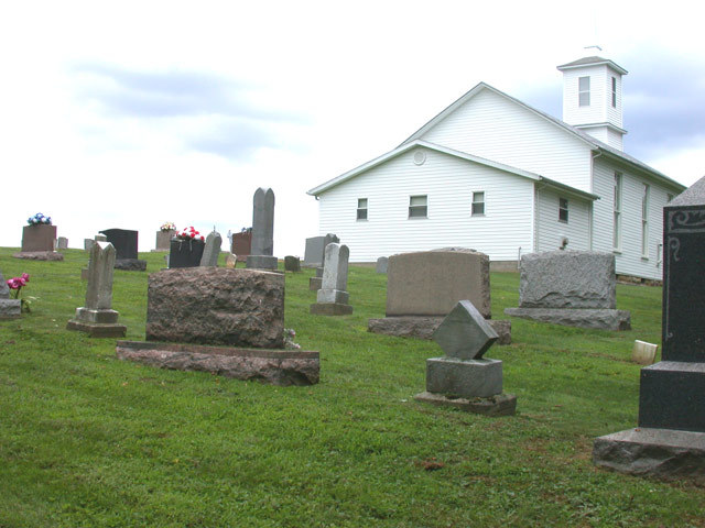
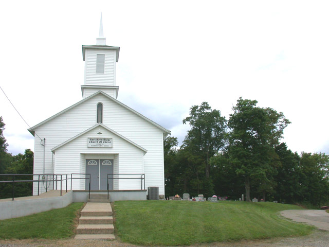
| Description | : | Hartshorn Ridge Church of Christ - church and cemetery The Hartshorn Ridge Church of Christ celebrated its One Hundredth Anniversary, October 24, 1987. It is located on County Road 12 in Wayne Township. There were ninety people present for the celebration, mostly descendants of the original founders. James Gallagher was the main speaker. Worship is now conducted regularly with approximately thirty in attendance. It is not known when this congregation had its beginning. The building first used for both a school and church meeting house was located near by. The first recorded baptism was in the year 1856 when George Washington Hartshorn was baptized... Read More |
frequently asked questions (FAQ):
-
Where is Hartshorn Ridge Cemetery?
Hartshorn Ridge Cemetery is located at Monroe County ,Ohio ,USA.
-
Hartshorn Ridge Cemetery cemetery's updated grave count on graveviews.com?
46 memorials
-
Where are the coordinates of the Hartshorn Ridge Cemetery?
Latitude: 39.7047950
Longitude: -81.2173339
Nearby Cemetories:
1. Christy Cemetery
Hilltop, Monroe County, USA
Coordinate: 39.7020230, -81.1968830
2. Hines Chapel Church of Christ Cemetery
Monroe County, USA
Coordinate: 39.6922900, -81.2398300
3. Knowlton Cemetery
Monroe County, USA
Coordinate: 39.6852989, -81.2052994
4. Mount Zion Methodist Cemetery
Lewisville, Monroe County, USA
Coordinate: 39.7238390, -81.2483750
5. Barber Ridge Cemetery
Wayne Township, Monroe County, USA
Coordinate: 39.7313995, -81.1819000
6. Hercher Cemetery
Monroe County, USA
Coordinate: 39.6702995, -81.2397003
7. Scott Cemetery
Monroe County, USA
Coordinate: 39.6643982, -81.2117004
8. Pleasant Ridge Church of Christ Cemetery
Graysville, Monroe County, USA
Coordinate: 39.6625850, -81.2076540
9. Stafford Cemetery
Stafford, Monroe County, USA
Coordinate: 39.7128500, -81.2723400
10. Conners Ridge Cemetery
Monroe County, USA
Coordinate: 39.7016983, -81.1613998
11. Sutherland Methodist Cemetery
Stafford, Monroe County, USA
Coordinate: 39.7281281, -81.2692804
12. Pioneer Cemetery
Graysville, Monroe County, USA
Coordinate: 39.6672000, -81.1741000
13. Creighton Ridge Church of Christ Cemetery
Marr, Monroe County, USA
Coordinate: 39.6629320, -81.2612340
14. Graysville Cemetery
Graysville, Monroe County, USA
Coordinate: 39.6632996, -81.1714020
15. Friendship Cemetery
Lewisville, Monroe County, USA
Coordinate: 39.7592010, -81.2221985
16. Cline Family Cemetery
Monroe County, USA
Coordinate: 39.6669620, -81.1624430
17. Vance Cemetery
Harriettsville, Noble County, USA
Coordinate: 39.6855760, -81.2877440
18. Lewisville German Lutheran Cemetery
Monroe County, USA
Coordinate: 39.7625700, -81.2184400
19. Evangelical Reformed Church Cemetery
Lewisville, Monroe County, USA
Coordinate: 39.7625723, -81.2184446
20. Drum Cemetery
Monroe County, USA
Coordinate: 39.7010994, -81.1414032
21. Parks Cemetery
Marr, Monroe County, USA
Coordinate: 39.6611500, -81.2681900
22. Moose Ridge Cemetery
Monroe County, USA
Coordinate: 39.7430992, -81.1544037
23. McVay Cemetery
Sycamore Valley, Monroe County, USA
Coordinate: 39.6444016, -81.2427979
24. Henthorn Cemetery
Monroe County, USA
Coordinate: 39.6418991, -81.1994019