
| Memorials | : | 1 |
| Location | : | Modum kommune, Norway |
| Coordinate | : | 59.9408250, 10.0006690 |
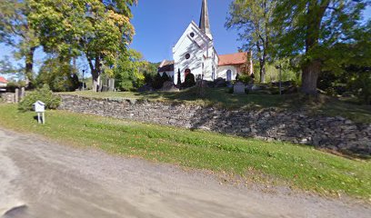
| Description | : | Modum, Buskerud, Norway Heggen Kirkegård Hegge Road (Heggenåsen rd), 3370 Vikersund Modum, Buskerud Norway Heggen Church is located between Vikersund and Åmot - on the east side of river. The church was originally built in Romanesque style, was expanded into a cruciform church in 1697-1725, and received a new chancel in 1832 and was expanded to the west in 1878 59.940825 10.000669 +59° 56' 27.04", +10° 0' 3.15 |
frequently asked questions (FAQ):
-
Where is Heggen Kirkegaard?
Heggen Kirkegaard is located at Modum kommune ,Buskerud fylke ,Norway.
-
Heggen Kirkegaard cemetery's updated grave count on graveviews.com?
1 memorials
-
Where are the coordinates of the Heggen Kirkegaard?
Latitude: 59.9408250
Longitude: 10.0006690
Nearby Cemetories:
1. Snarum
Snarum, Modum kommune, Norway
Coordinate: 60.0258190, 9.8682140
2. Bakke Kirke
Øvre Eiker kommune, Norway
Coordinate: 59.8359000, 9.8726000
3. Sjåstad
Lier kommune, Norway
Coordinate: 59.8499235, 10.2138581
4. Sylling Churchyard
Sylling, Lier kommune, Norway
Coordinate: 59.8987580, 10.2806720
5. Tyristrand Cemetery
Tyristrand, Ringerike kommune, Norway
Coordinate: 60.0860800, 10.0974900
6. Haug Kirke
Hokksund, Øvre Eiker kommune, Norway
Coordinate: 59.7649980, 9.9046820
7. Nedre Eiker Churchyard
Krokstadelva, Nedre Eiker kommune, Norway
Coordinate: 59.7573380, 10.0363650
8. Hole Church Cemetery
Hole kommune, Norway
Coordinate: 60.0975800, 10.2165600
9. Åssiden Cemetery
Drammen, Drammen kommune, Norway
Coordinate: 59.7591686, 10.1154243
10. Frogner Cemetery
Lierbyen, Lier kommune, Norway
Coordinate: 59.7791730, 10.2240060
11. Bragernes Cemetery
Drammen, Drammen kommune, Norway
Coordinate: 59.7481560, 10.2016710
12. Strømsø Gravplass
Stromso, Drammen kommune, Norway
Coordinate: 59.7355911, 10.2072084
13. Norderhov Church Cemetery
Honefoss, Ringerike kommune, Norway
Coordinate: 60.1313480, 10.2694300
14. Lyngdal Kirke
Lyngdal, Flesberg kommune, Norway
Coordinate: 59.9105467, 9.5291613
15. Asker Church
Asker, Asker kommune, Norway
Coordinate: 59.8434020, 10.4358860
16. Tanum Churchyard
Bærum kommune, Norway
Coordinate: 59.8950330, 10.4790930
17. Bryn Kirke
Baerums Verk, Bærum kommune, Norway
Coordinate: 59.9214260, 10.4872140
18. Tangen Cemetery
Tangen, Drammen kommune, Norway
Coordinate: 59.7257300, 10.2484600
19. Fiskum Church Cemetery
Øvre Eiker kommune, Norway
Coordinate: 59.6989035, 9.8100539
20. Røyken Kirkegaard
Royken, Røyken kommune, Norway
Coordinate: 59.7467160, 10.3850690
21. Steinsskogen Cemetery
Baerums Verk, Bærum kommune, Norway
Coordinate: 59.9318020, 10.5530360
22. Henie Onstad Kunstsenter Grounds
Sandvika, Bærum kommune, Norway
Coordinate: 59.8886700, 10.5529220
23. Haug Cemetery
Honefoss, Ringerike kommune, Norway
Coordinate: 60.1740280, 10.3206160
24. Haslum Cemetery
Haslum, Bærum kommune, Norway
Coordinate: 59.9247660, 10.5671860