
| Memorials | : | 30 |
| Location | : | Bobbington, South Staffordshire Borough, England |
| Website | : | www.holycrossbobbington.co.uk/ |
| Coordinate | : | 52.5011697, -2.2450663 |
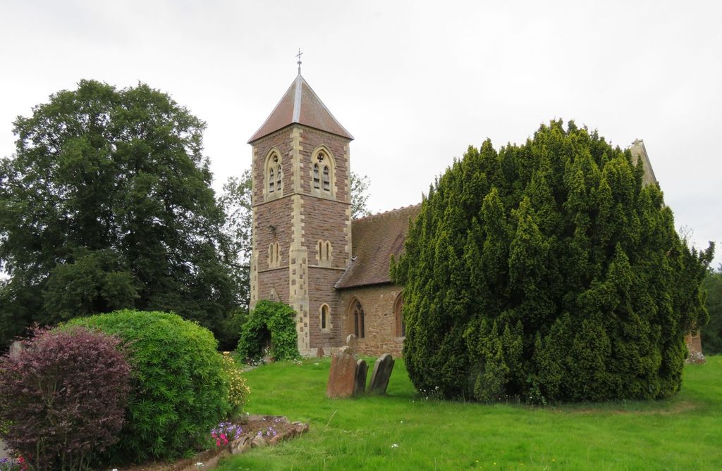
| Description | : | Holy Cross dates from the 12th century and is an appealingly simple village church, Grade II* listed, stone built with a Norman aracade, set in the small village of Bobbington in South Staffordshire close to the Shropshire border. |
frequently asked questions (FAQ):
-
Where is Holy Cross Churchyard?
Holy Cross Churchyard is located at Six Ashes Road Bobbington, South Staffordshire Borough ,Staffordshire , DY7 5BZEngland.
-
Holy Cross Churchyard cemetery's updated grave count on graveviews.com?
30 memorials
-
Where are the coordinates of the Holy Cross Churchyard?
Latitude: 52.5011697
Longitude: -2.2450663
Nearby Cemetories:
1. Holy Innocents Churchyard
Alveley, Shropshire Unitary Authority, England
Coordinate: 52.4932817, -2.2902335
2. Sytch Lane Cemetery
Wombourne, South Staffordshire Borough, England
Coordinate: 52.5261590, -2.1892040
3. Earl of Dudley's Memory Garden
Himley, South Staffordshire Borough, England
Coordinate: 52.5177000, -2.1739000
4. St. Michael & All Angels Churchyard
Himley, South Staffordshire Borough, England
Coordinate: 52.5177560, -2.1738320
5. St Benedict Biscop Churchyard
Wombourne, South Staffordshire Borough, England
Coordinate: 52.5361394, -2.1834008
6. All Saints Churchyard
Claverley, Shropshire Unitary Authority, England
Coordinate: 52.5382800, -2.3069010
7. St Mary Churchyard
Kingswinford, Metropolitan Borough of Dudley, England
Coordinate: 52.5015430, -2.1581310
8. Holy Trinity Church
Wordsley, Metropolitan Borough of Dudley, England
Coordinate: 52.4802420, -2.1588740
9. St. James' Churchyard
Wollaston, Metropolitan Borough of Dudley, England
Coordinate: 52.4602799, -2.1605207
10. Stourbridge Cemetery and Crematorium
Stourbridge, Metropolitan Borough of Dudley, England
Coordinate: 52.4530270, -2.1682470
11. Gornal Wood Cemetery and Crematorium
Gornal Wood, Metropolitan Borough of Dudley, England
Coordinate: 52.5113680, -2.1340090
12. St. John Churchyard
Brockmoor, Metropolitan Borough of Dudley, England
Coordinate: 52.4858200, -2.1337500
13. Amblecote
Stourbridge, Metropolitan Borough of Dudley, England
Coordinate: 52.4630297, -2.1490620
14. Holy Trinity Churchyard
Amblecote, Metropolitan Borough of Dudley, England
Coordinate: 52.4629900, -2.1489400
15. St. Mark's Churchyard
Pensnett, Metropolitan Borough of Dudley, England
Coordinate: 52.5023660, -2.1267150
16. Penn Cemetery
Penn, Metropolitan Borough of Wolverhampton, England
Coordinate: 52.5563850, -2.1641210
17. St James The Great Churchyard
Lower Gornal, Metropolitan Borough of Dudley, England
Coordinate: 52.5194700, -2.1249300
18. Brierley Hill Baptist Churchyard
Brierley Hill, Metropolitan Borough of Dudley, England
Coordinate: 52.4767380, -2.1268700
19. St Bartholomew Churchyard
Penn, Metropolitan Borough of Wolverhampton, England
Coordinate: 52.5554900, -2.1569250
20. St Michael Churchyard
Brierley Hill, Metropolitan Borough of Dudley, England
Coordinate: 52.4794080, -2.1245920
21. Roman Catholic Cemetery
Stourbridge, Metropolitan Borough of Dudley, England
Coordinate: 52.4403800, -2.1629600
22. Saint Mary the Virgin Churchyard
Alveley, Shropshire Unitary Authority, England
Coordinate: 52.4581590, -2.3553520
23. St. Peter's Churchyard
Cookley, Wyre Forest District, England
Coordinate: 52.4193280, -2.2334370
24. Saint Augustine of Hippo Churchyard
Dudley, Metropolitan Borough of Dudley, England
Coordinate: 52.5000570, -2.1084920