
| Memorials | : | 0 |
| Location | : | Sandbach, Cheshire East Unitary Authority, England |
| Coordinate | : | 53.1439600, -2.3643100 |
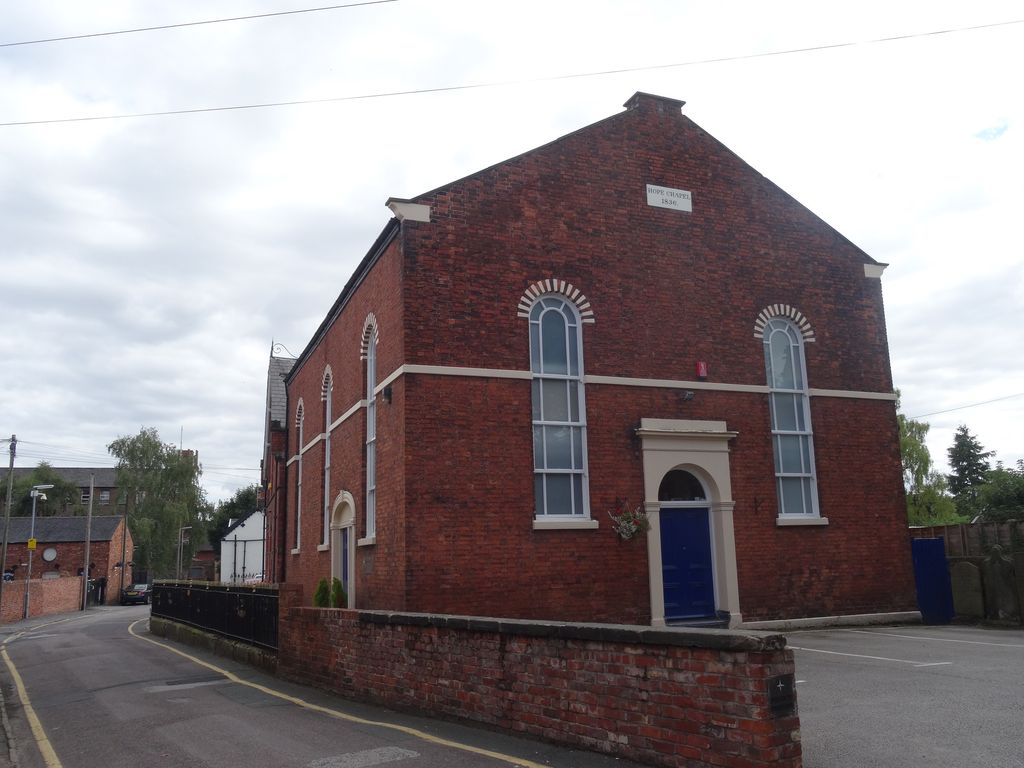
| Description | : | Hope Chapel was built as an Independent (Congregational Chapel) in 1836 and officially opened and dedicated in 1837 by Preacher Reverend J Hill of Oxford and the Reverend Samuel Luke of Chester. It is in red brick with stone dressings. The entrance front is pedimented and contains a central doorway with a stuccoed surround, an entablature containing a cornice, and a semicircular fanlight. In the gable is a datestone. Flanking the doorway are round-headed lancet windows. There are three similar windows along the street and a doorway with an elliptical tympanum. In 1860 a Sunday School and burial ground were added... Read More |
frequently asked questions (FAQ):
-
Where is Hope Chapel?
Hope Chapel is located at Hope Street Sandbach, Cheshire East Unitary Authority ,Cheshire , CW11 1BAEngland.
-
Hope Chapel cemetery's updated grave count on graveviews.com?
0 memorials
-
Where are the coordinates of the Hope Chapel?
Latitude: 53.1439600
Longitude: -2.3643100
Nearby Cemetories:
1. St Mary Churchyard
Sandbach, Cheshire East Unitary Authority, England
Coordinate: 53.1435380, -2.3610030
2. Sandbach Cemetery
Sandbach, Cheshire East Unitary Authority, England
Coordinate: 53.1410080, -2.3556550
3. St Peter Churchyard
Elworth, Cheshire East Unitary Authority, England
Coordinate: 53.1485950, -2.3898080
4. St. John's Churchyard
Sandbach Heath, Cheshire East Unitary Authority, England
Coordinate: 53.1506690, -2.3371800
5. The Church on Ettiley Heath
Ettiley Heath, Cheshire East Unitary Authority, England
Coordinate: 53.1387412, -2.3964267
6. Christ Church Churchyard
Wheelock, Cheshire East Unitary Authority, England
Coordinate: 53.1247500, -2.3768200
7. Wheelock Heath Baptist Chapelyard
Sandbach, Cheshire East Unitary Authority, England
Coordinate: 53.1132940, -2.3730320
8. St Oswald Churchyard
Brereton, Cheshire East Unitary Authority, England
Coordinate: 53.1797180, -2.3284870
9. St. Leonard's Churchyard
Warmingham, Cheshire East Unitary Authority, England
Coordinate: 53.1462213, -2.4367574
10. St John the Baptist Churchyard
Smallwood, Cheshire East Unitary Authority, England
Coordinate: 53.1381700, -2.2913100
11. St. Matthew's Churchyard
Haslington, Cheshire East Unitary Authority, England
Coordinate: 53.1011010, -2.3933740
12. Christ Church Churchyard
Alsager, Cheshire East Unitary Authority, England
Coordinate: 53.0977630, -2.3166660
13. St Michael's
Haslington, Cheshire East Unitary Authority, England
Coordinate: 53.0946170, -2.4097820
14. St. Luke Churchyard
Holmes Chapel, Cheshire East Unitary Authority, England
Coordinate: 53.2020350, -2.3575080
15. St Mary Magdalene Churchyard
Alsager, Cheshire East Unitary Authority, England
Coordinate: 53.0960640, -2.3071370
16. Crewe Cemetery & Crematorium
Crewe, Cheshire East Unitary Authority, England
Coordinate: 53.1030540, -2.4415159
17. St. Michael Churchyard
Crewe, Cheshire East Unitary Authority, England
Coordinate: 53.1058200, -2.4475200
18. All Saint's Churchyard
Somerford, Cheshire East Unitary Authority, England
Coordinate: 53.1803580, -2.2786350
19. All Saints Churchyard
Odd Rode, Cheshire East Unitary Authority, England
Coordinate: 53.1142100, -2.2644690
20. St. Michael and All Angels Churchyard
Middlewich, Cheshire East Unitary Authority, England
Coordinate: 53.1926870, -2.4445600
21. St Peter Churchyard
Minshull Vernon, Cheshire East Unitary Authority, England
Coordinate: 53.1308770, -2.4772320
22. Swettenham Cemetery
Swettenham, Cheshire East Unitary Authority, England
Coordinate: 53.2013150, -2.2996470
23. Meadow Brook Cemetery
Crewe, Cheshire East Unitary Authority, England
Coordinate: 53.1083460, -2.4690380
24. Middlewich Cemetery
Middlewich, Cheshire East Unitary Authority, England
Coordinate: 53.1942230, -2.4526240