
| Memorials | : | 9 |
| Location | : | Kirkham, Ryedale District, England |
| Coordinate | : | 54.0826180, -0.8768470 |
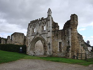
| Description | : | In 1121, his son having died after a fall from his horse, Walter l'Espec founded Kirkham Priory with a community of Augustinian canons in memory his memory, with the altar being placed on the very spot where he died. A very singular tradition belongs to Kirkham Priory. Henry VIII, at the dissolution, bestowed the priory, then a nunnery, on one of his courtiers, a greedy and heartless man. He took immediate possession, insisting on the instant departure of the nuns, with great harshness and cruelty. They issued forth, sad and weeping at leaving their lovely home for the cruel and... Read More |
frequently asked questions (FAQ):
-
Where is Kirkham Priory?
Kirkham Priory is located at Kirkham, Ryedale District ,North Yorkshire ,England.
-
Kirkham Priory cemetery's updated grave count on graveviews.com?
9 memorials
-
Where are the coordinates of the Kirkham Priory?
Latitude: 54.0826180
Longitude: -0.8768470
Nearby Cemetories:
1. St Michael Churchyard
Crambe, Ryedale District, England
Coordinate: 54.0744550, -0.8809390
2. St. Mary's Churchyard
Westow, Ryedale District, England
Coordinate: 54.0846190, -0.8406850
3. St John the Evangelist Churchyard
Welburn (Malton), Ryedale District, England
Coordinate: 54.1008850, -0.8985440
4. Howsham Churchyard
Howsham, Ryedale District, England
Coordinate: 54.0565520, -0.8755670
5. St. Margaret's Churchyard
Huttons Ambo, Ryedale District, England
Coordinate: 54.1066490, -0.8490640
6. All Saints Churchyard
Foston, Ryedale District, England
Coordinate: 54.0775719, -0.9331510
7. Castle Howard Mausoleum
Castle Howard, Ryedale District, England
Coordinate: 54.1173870, -0.8886900
8. St Martin Churchyard
Bulmer, Ryedale District, England
Coordinate: 54.0997510, -0.9317700
9. St Botolph Churchyard
Bossall, Ryedale District, England
Coordinate: 54.0375570, -0.9047540
10. Burythorpe Churchyard
Burythorpe, Ryedale District, England
Coordinate: 54.0752951, -0.7955984
11. St Peter and St Paul Churchyard
Scrayingham, Ryedale District, England
Coordinate: 54.0342510, -0.8826130
12. Coneysthorpe Cemetery
Coneysthorpe, Ryedale District, England
Coordinate: 54.1308750, -0.9042820
13. St Andrew Churchyard
Langton, Ryedale District, England
Coordinate: 54.0934510, -0.7834680
14. St John the Baptist
Acklam, Ryedale District, England
Coordinate: 54.0451010, -0.8006330
15. St Lawrence Churchyard
Flaxton, Ryedale District, England
Coordinate: 54.0508680, -0.9624500
16. Terrington Burial Ground
Terrington, Ryedale District, England
Coordinate: 54.1231640, -0.9717280
17. St John the Evangelist Churchyard
Buttercrambe, Ryedale District, England
Coordinate: 54.0137300, -0.8812900
18. St Helen Churchyard
Amotherby, Ryedale District, England
Coordinate: 54.1512000, -0.8521000
19. All Saints Churchyard
Appleton-le-Street, Ryedale District, England
Coordinate: 54.1529500, -0.8766300
20. St Helen and the Holy Cross Churchyard
Sheriff Hutton, Ryedale District, England
Coordinate: 54.0882280, -0.9965280
21. St Peter Churchyard
Norton, Ryedale District, England
Coordinate: 54.1289040, -0.7861910
22. St. Leonard with St. Mary Churchyard
Malton, Ryedale District, England
Coordinate: 54.1348110, -0.7946110
23. All Saints Churchyard
Terrington, Ryedale District, England
Coordinate: 54.1282770, -0.9735330
24. Norton Cemetery
Norton, Ryedale District, England
Coordinate: 54.1306400, -0.7834200