
| Memorials | : | 13 |
| Location | : | Roane County, USA |
| Coordinate | : | 38.5721090, -81.2053050 |
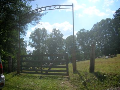
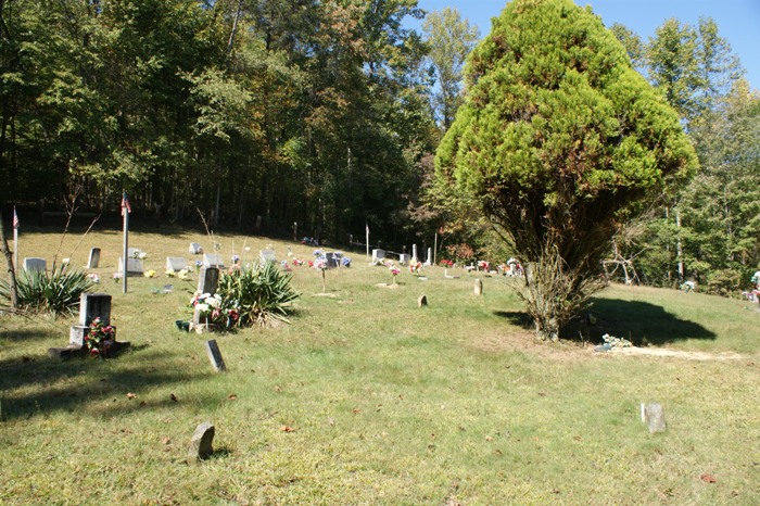
| Description | : | Established around 1890 as Community burial ground. No restrictions as to type and placing of markers; fenced, not landscaped; condition, poor. Earliest stone dated 1890. Marked graves, 11; unmarked graves, 43. This cemetery is currently in excellent condition with many new headstones for those previously unmarked. |
frequently asked questions (FAQ):
-
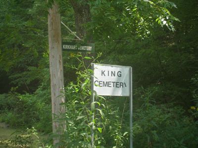
Where is Kirkhart-King Cemetery?
Kirkhart-King Cemetery is located at 1305 Grannies Creek Rd Roane County ,West Virginia ,USA.
-
Kirkhart-King Cemetery cemetery's updated grave count on graveviews.com?
13 memorials
-
Where are the coordinates of the Kirkhart-King Cemetery?
Latitude: 38.5721090
Longitude: -81.2053050

Nearby Cemetories:
1. O'Dell Cemetery
Amma, Roane County, USA
Coordinate: 38.5540490, -81.2366440
2. Hill Cemetery
Amma, Roane County, USA
Coordinate: 38.5359890, -81.1981760
3. Cook Cemetery
Roane County, USA
Coordinate: 38.5852800, -81.2527010
4. Reed Cemetery
Amma, Roane County, USA
Coordinate: 38.5614014, -81.2608032
5. Amma Cemetery
Amma, Roane County, USA
Coordinate: 38.5660190, -81.2670710
6. Knight Cemetery
Roane County, USA
Coordinate: 38.6099170, -81.2476170
7. Alkanah Carper Cemetery
Roane County, USA
Coordinate: 38.6063995, -81.2544022
8. Hall Cemetery
Clay County, USA
Coordinate: 38.5311012, -81.1605988
9. Ashley Cemetery
Clio, Roane County, USA
Coordinate: 38.5728930, -81.2831610
10. Ashley Waitman Cemetery
Amma, Roane County, USA
Coordinate: 38.5727997, -81.2835999
11. Belcher Cemetery
Ovapa, Clay County, USA
Coordinate: 38.5260640, -81.1519610
12. Hively Cemetery
Clay County, USA
Coordinate: 38.5388985, -81.1343994
13. Ovapa Church of God Cemetery
Ovapa, Clay County, USA
Coordinate: 38.5259680, -81.1470270
14. Wyant Cemetery
Ovapa, Clay County, USA
Coordinate: 38.5161770, -81.1569900
15. Adkins Family Cemetery
Roane County, USA
Coordinate: 38.5238991, -81.2718964
16. Payne Cemetery
Clio, Roane County, USA
Coordinate: 38.5891991, -81.2957993
17. Jarvis Cemetery
Left Hand, Roane County, USA
Coordinate: 38.6476640, -81.2186470
18. Groves Cemetery
Roane County, USA
Coordinate: 38.6081000, -81.2964000
19. Procious Cemetery
Procious, Clay County, USA
Coordinate: 38.4928080, -81.1939270
20. George Groves Cemetery
Left Hand, Roane County, USA
Coordinate: 38.6083861, -81.2963389
21. Armstead Cemetery #3
Clio, Roane County, USA
Coordinate: 38.5694800, -81.3097500
22. Foreman Cemetery
Procious, Clay County, USA
Coordinate: 38.4935660, -81.2351740
23. Samples Harvey Cemetery
Procious, Clay County, USA
Coordinate: 38.4900060, -81.2049670
24. Groves Cemetery
Roane County, USA
Coordinate: 38.6123560, -81.2968860