
| Memorials | : | 0 |
| Location | : | Cazadero, Sonoma County, USA |
| Coordinate | : | 38.5036910, -123.0790620 |
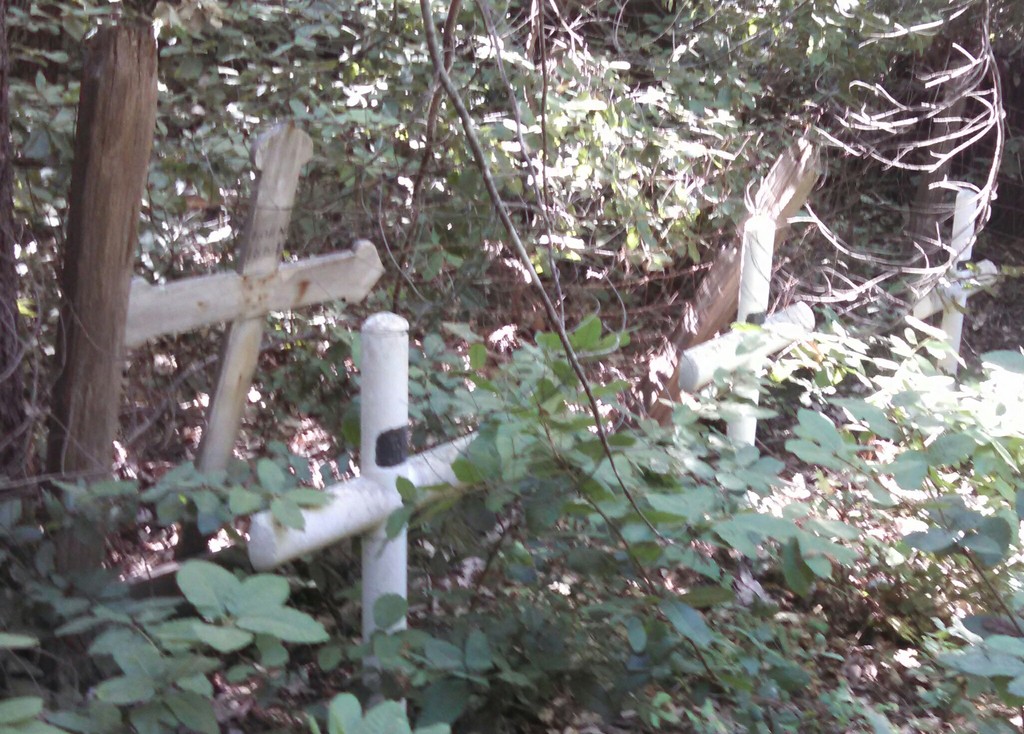
| Description | : | The Kricke Ranch Cemetery is listed in the Sonoma County Cemetery Records Book, which was published in 1934. This book gives the location of the ranch and cemetery as the Cazadero District. It goes on to specify that the ranch, by the year 1934, was called the Goring Ranch. The Cazadero District includes the small town of Cazadero, which still exists today, as well as the surrounding open land consisting mostly of ranches and farms in that day. The specific location of the cemetery at the ranch is unknown at this time. However, an 1898 Sonoma County Atlas shows that... Read More |
frequently asked questions (FAQ):
-
Where is Kricke Ranch Cemetery?
Kricke Ranch Cemetery is located at Cazadero, Sonoma County ,California ,USA.
-
Kricke Ranch Cemetery cemetery's updated grave count on graveviews.com?
0 memorials
-
Where are the coordinates of the Kricke Ranch Cemetery?
Latitude: 38.5036910
Longitude: -123.0790620
Nearby Cemetories:
1. Del Stewart Ranch Cemetery
Cazadero, Sonoma County, USA
Coordinate: 38.4998290, -123.0793090
2. Elim Grove Cemetery
Cazadero, Sonoma County, USA
Coordinate: 38.5169590, -123.0887470
3. Otis Ranch Cemetery
Cazadero, Sonoma County, USA
Coordinate: 38.5313260, -123.0886990
4. Walter Brain Ranch Cemetery
Cazadero, Sonoma County, USA
Coordinate: 38.5332340, -123.0852850
5. Cunningham Ranch Cemetery
Cazadero, Sonoma County, USA
Coordinate: 38.5405680, -123.1089740
6. Duncans Mills Cemetery
Duncans Mills, Sonoma County, USA
Coordinate: 38.4593560, -123.0547780
7. Saint Catherines Church Cemetery
Monte Rio, Sonoma County, USA
Coordinate: 38.4691010, -123.0104980
8. Redwood Memorial Gardens
Guerneville, Sonoma County, USA
Coordinate: 38.5071983, -122.9927979
9. William Churchman Ranch Cemetery
Cazadero, Sonoma County, USA
Coordinate: 38.5671810, -123.1205180
10. Trosper Ranch Cemetery
Cazadero, Sonoma County, USA
Coordinate: 38.5720120, -123.1201740
11. Slattery Ranch Cemetery
Cazadero, Sonoma County, USA
Coordinate: 38.5529520, -123.1593130
12. Howie Ranch Cemetery
Cazadero, Sonoma County, USA
Coordinate: 38.5644960, -123.2060050
13. McPeak Cemetery
Forestville, Sonoma County, USA
Coordinate: 38.5098190, -122.9280929
14. McPeak Cemetery
Hacienda, Sonoma County, USA
Coordinate: 38.5097008, -122.9272003
15. Seaview Cemetery
Seaview, Sonoma County, USA
Coordinate: 38.5433006, -123.2230988
16. Fort Ross State Historic Park Cemetery
Jenner, Sonoma County, USA
Coordinate: 38.5147490, -123.2400160
17. Druids Occidental Cemetery
Occidental, Sonoma County, USA
Coordinate: 38.4104996, -122.9419022
18. Benitz Ranch Cemetery
Jenner, Sonoma County, USA
Coordinate: 38.5304480, -123.2692660
19. Forestview Cemetery
Forestville, Sonoma County, USA
Coordinate: 38.4677010, -122.8834000
20. Green Valley Cemetery
Sebastopol, Sonoma County, USA
Coordinate: 38.4424019, -122.8869019
21. Rouff - Thomas Cemetery
Cloverdale, Sonoma County, USA
Coordinate: 38.5404960, -123.2851310
22. Gilliam Cemetery
Graton, Sonoma County, USA
Coordinate: 38.4314995, -122.8816986
23. Saint Theresa of Avila Church Cemetery
Bodega, Sonoma County, USA
Coordinate: 38.3461342, -122.9723663
24. Calvary Cemetery
Bodega, Sonoma County, USA
Coordinate: 38.3414993, -122.9749985