
| Memorials | : | 60 |
| Location | : | Lee-on-the-Solent, Gosport Borough, England |
| Coordinate | : | 50.8045110, -1.2068440 |
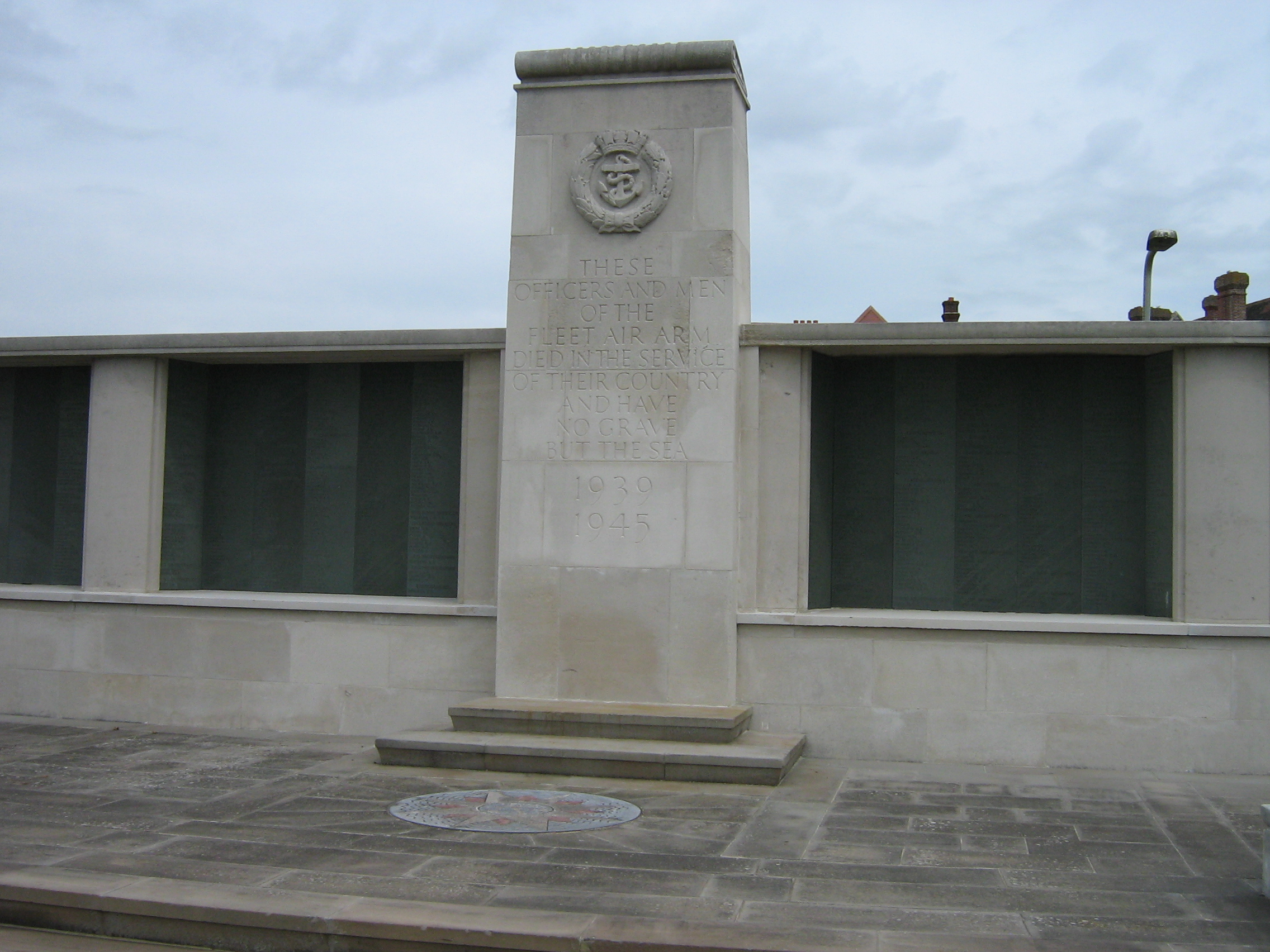
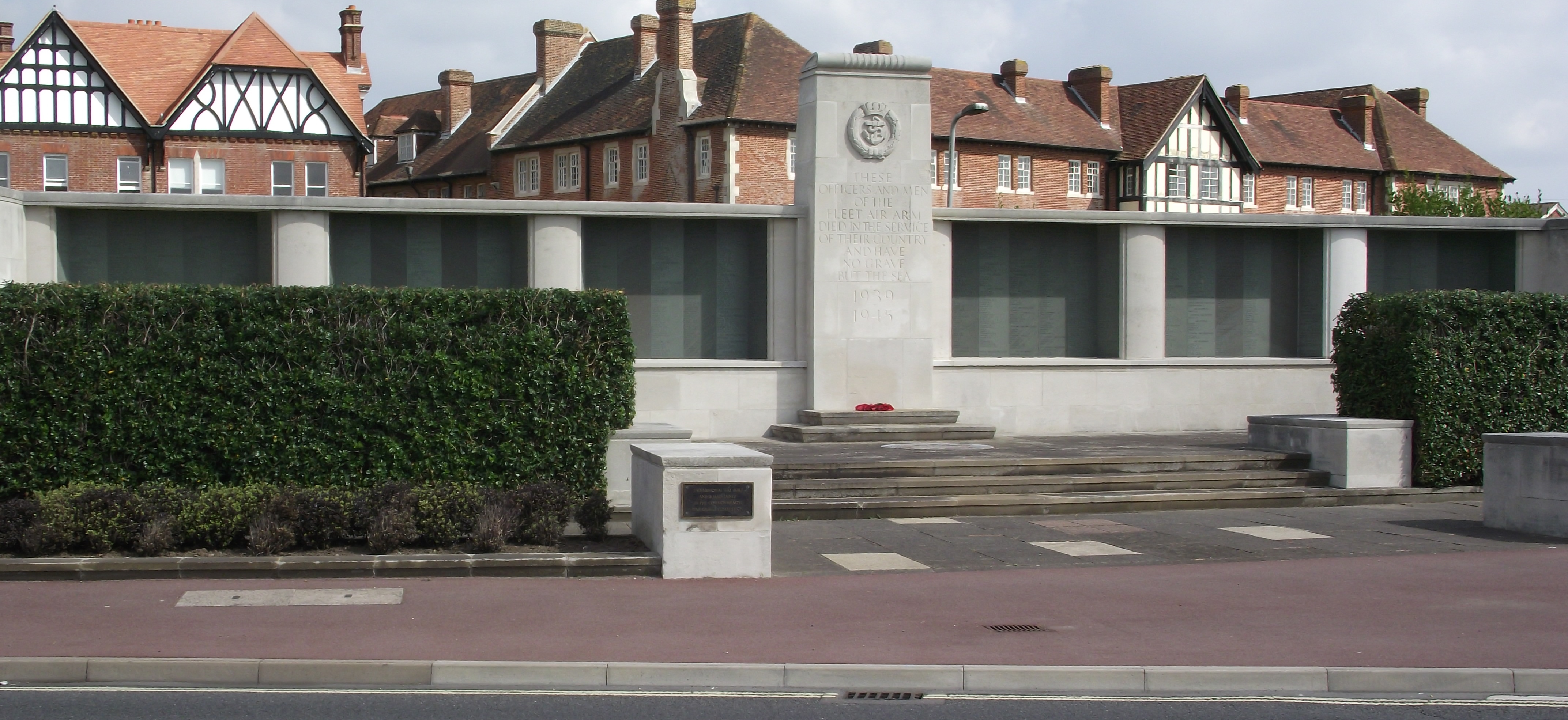
| Description | : | The Fleet Air Arm military service branch of England performed reconnaissance support in France, the Netherlands, North Africa, Italy and the Far East during the Second World War. They operated from aircraft carriers of which seven were lost during the war. From the Commonwealth War Graves Commission website "The principal base of the Fleet Air Arm, Lee-on-the-Solent, Hampshire, was chosen as the site for the memorial to almost 2,000 men of that service who died during the Second World War and who have no known grave." Their names are carved into six panels of Westmorland slate which... Read More |
frequently asked questions (FAQ):
-
Where is Lee-On-Solent Memorial?
Lee-On-Solent Memorial is located at Richmond Road Lee-on-the-Solent, Gosport Borough ,Hampshire , PO13 9NTEngland.
-
Lee-On-Solent Memorial cemetery's updated grave count on graveviews.com?
58 memorials
-
Where are the coordinates of the Lee-On-Solent Memorial?
Latitude: 50.8045110
Longitude: -1.2068440
Nearby Cemetories:
1. St Mary the Virgin Churchyard
Gosport, Gosport Borough, England
Coordinate: 50.8112690, -1.1724800
2. Crofton Old Churchyard
Stubbington, Fareham Borough, England
Coordinate: 50.8344830, -1.2183660
3. St Edmund Churchyard
Stubbington, Fareham Borough, England
Coordinate: 50.8345130, -1.2185160
4. Crofton Cemetery
Stubbington, Fareham Borough, England
Coordinate: 50.8364160, -1.2173260
5. Ann's Hill Cemetery
Gosport, Gosport Borough, England
Coordinate: 50.7982670, -1.1549450
6. St Thomas the Apostle Churchyard
Gosport, Gosport Borough, England
Coordinate: 50.8137570, -1.1484570
7. St Mary Churchyard
Alverstoke, Gosport Borough, England
Coordinate: 50.7856760, -1.1480810
8. St John the Evangelist Churchyard
Gosport, Gosport Borough, England
Coordinate: 50.7995600, -1.1397800
9. St. Mark's Churchyard
Alverstoke, Gosport Borough, England
Coordinate: 50.7826800, -1.1436100
10. Posbrook Lane Cemetery
Titchfield, Fareham Borough, England
Coordinate: 50.8463100, -1.2403000
11. St. Peter's Churchyard
Titchfield, Fareham Borough, England
Coordinate: 50.8490620, -1.2330780
12. Turkish Naval Cemetery
Gosport, Gosport Borough, England
Coordinate: 50.7840710, -1.1383980
13. Clayhall Naval Cemetery
Gosport, Gosport Borough, England
Coordinate: 50.7833862, -1.1373420
14. Holy Trinity Churchyard
Fareham, Fareham Borough, England
Coordinate: 50.8522480, -1.1834370
15. St. Peter and St. Paul Churchyard
Fareham, Fareham Borough, England
Coordinate: 50.8556300, -1.1753200
16. Holy Trinity Churchyard
Gosport, Gosport Borough, England
Coordinate: 50.7930600, -1.1207620
17. Fareham Cemetery
Fareham, Fareham Borough, England
Coordinate: 50.8623050, -1.1795840
18. HMS Victory Ship
Portsmouth, Portsmouth Unitary Authority, England
Coordinate: 50.8017290, -1.1095590
19. Portchester Crematorium Gardens
Portchester, Fareham Borough, England
Coordinate: 50.8499680, -1.1382190
20. Roman Grove Cemetery
Portchester, Fareham Borough, England
Coordinate: 50.8384600, -1.1206200
21. Portsmouth Cathedral Churchyard
Portsmouth, Portsmouth Unitary Authority, England
Coordinate: 50.7904650, -1.1043720
22. Royal Garrison Churchyard
Portsmouth, Portsmouth Unitary Authority, England
Coordinate: 50.7890180, -1.1040520
23. Royal Garrison Church Churchyard
Plymouth, Plymouth Unitary Authority, England
Coordinate: 50.7889690, -1.1039650
24. St. Mary's Churchyard
Portchester, Fareham Borough, England
Coordinate: 50.8366280, -1.1134270