
| Memorials | : | 6 |
| Location | : | Kansas City, Jackson County, USA |
| Coordinate | : | 39.0433100, -94.4957500 |
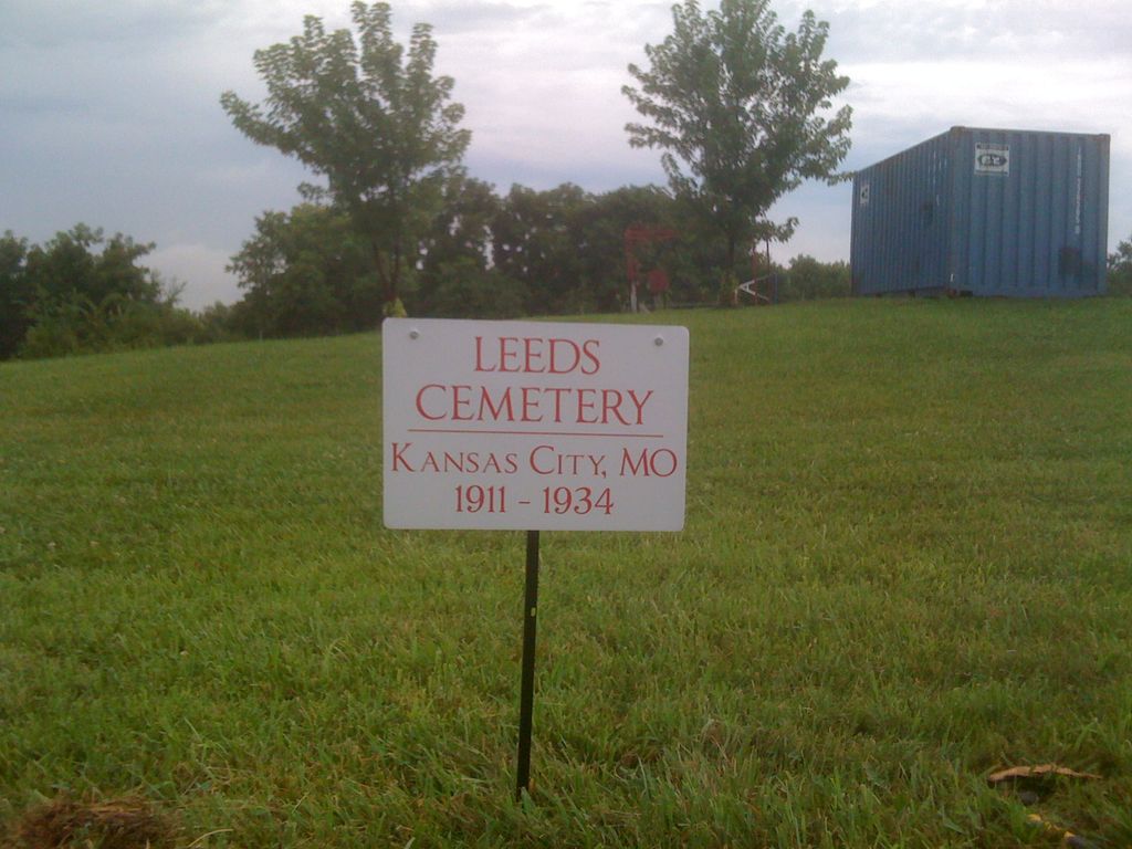
| Description | : | In 1911, the Union Cemetery of Kansas City closed their Potter's Field. In May 1911, the new Potter's Field opened at the Municipal Farms and was known as Leeds Cemetery. It is located Southwest of the Kansas City Sports Complex. It is bordered on the west by Eastern Avenue, on the north by the police helicopter pad, on the east by Round Grove Creek and on the south by the National Guard Armory. Grave sites were marked with a metal stake that had the name of the deceased written on paper and held under a piece... Read More |
frequently asked questions (FAQ):
-
Where is Leeds Cemetery?
Leeds Cemetery is located at Kansas City, Jackson County ,Missouri ,USA.
-
Leeds Cemetery cemetery's updated grave count on graveviews.com?
6 memorials
-
Where are the coordinates of the Leeds Cemetery?
Latitude: 39.0433100
Longitude: -94.4957500
Nearby Cemetories:
1. Cole Cemetery
Kansas City, Jackson County, USA
Coordinate: 39.0331000, -94.4992400
2. Collings Cemetery
Kansas City, Jackson County, USA
Coordinate: 39.0206200, -94.4908000
3. Rice Cemetery
Kansas City, Jackson County, USA
Coordinate: 39.0193400, -94.4955700
4. Pitcher Cemetery
Independence, Jackson County, USA
Coordinate: 39.0635986, -94.4702988
5. Mount Carmel Cemetery
Raytown, Jackson County, USA
Coordinate: 39.0228004, -94.4705963
6. Brooking Cemetery
Raytown, Jackson County, USA
Coordinate: 39.0269012, -94.4597015
7. Blue Ridge Lawn Memorial Gardens
Kansas City, Jackson County, USA
Coordinate: 39.0760002, -94.4717026
8. Thomas H. Swope Memorial
Kansas City, Jackson County, USA
Coordinate: 39.0033000, -94.5169100
9. Highland Cemetery
Kansas City, Jackson County, USA
Coordinate: 39.0853004, -94.4760971
10. West Family Cemetery
Raytown, Jackson County, USA
Coordinate: 39.0020900, -94.4729600
11. Floral Hills Cemetery
Kansas City, Jackson County, USA
Coordinate: 38.9972000, -94.4878006
12. Kehilath Israel Blue Ridge Cemetery
Independence, Jackson County, USA
Coordinate: 39.0875015, -94.4766998
13. West Fork Baptist Cemetery
Bristol, Jackson County, USA
Coordinate: 39.0110100, -94.4443700
14. Campground Cemetery
Raytown, Jackson County, USA
Coordinate: 39.0380000, -94.4295700
15. Hill Park Cemetery
Independence, Jackson County, USA
Coordinate: 39.0835991, -94.4539032
16. Mount Saint Mary Catholic Cemetery
Kansas City, Jackson County, USA
Coordinate: 39.0856018, -94.5357971
17. Lincoln Cemetery
Kansas City, Jackson County, USA
Coordinate: 39.0946999, -94.4805984
18. Mount Washington Cemetery
Independence, Jackson County, USA
Coordinate: 39.0957985, -94.4757996
19. Elmwood Cemetery
Kansas City, Jackson County, USA
Coordinate: 39.0960999, -94.5255966
20. Boone-Hays Cemetery
Kansas City, Jackson County, USA
Coordinate: 39.0129395, -94.5630493
21. Mount Olivet Cemetery and Mausoleum
Kansas City, Jackson County, USA
Coordinate: 38.9838982, -94.4785995
22. Sechrest Family Cemetery
Kansas City, Jackson County, USA
Coordinate: 38.9822300, -94.4880600
23. Memorial Park Cemetery
Kansas City, Jackson County, USA
Coordinate: 38.9805984, -94.5143967
24. Kauffman Memorial Garden
Kansas City, Jackson County, USA
Coordinate: 39.0398100, -94.5789700