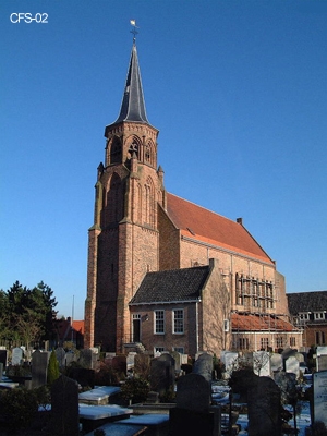
| Memorials | : | 0 |
| Location | : | Loosduinen, Den Haag Municipality, Netherlands |
| Coordinate | : | 52.0505920, 4.2349720 |
frequently asked questions (FAQ):
-
Where is Loosduinen Abbey Church Cemetery?
Loosduinen Abbey Church Cemetery is located at Loosduinen, Den Haag Municipality ,Zuid-Holland ,Netherlands.
-
Loosduinen Abbey Church Cemetery cemetery's updated grave count on graveviews.com?
0 memorials
-
Where are the coordinates of the Loosduinen Abbey Church Cemetery?
Latitude: 52.0505920
Longitude: 4.2349720
Nearby Cemetories:
1. Westduin Cemetery
Den Haag Municipality, Netherlands
Coordinate: 52.0570000, 4.2244500
2. Begraafplaats Oud Eik en Duinen
The Hague (Den Haag), Den Haag Municipality, Netherlands
Coordinate: 52.0677680, 4.2647120
3. Begraafplaats Nieuw Eykenduynen
The Hague (Den Haag), Den Haag Municipality, Netherlands
Coordinate: 52.0683300, 4.2677800
4. Monster General Cemetery
Monster, Westland Municipality, Netherlands
Coordinate: 52.0293500, 4.1781900
5. Algemene begraafplaats Wateringen
Wateringen, Westland Municipality, Netherlands
Coordinate: 52.0233765, 4.2847066
6. Sint-Jacobskerk
The Hague (Den Haag), Den Haag Municipality, Netherlands
Coordinate: 52.0772429, 4.3063240
7. Yardenhuis van Rijswijk
Rijswijk, Rijswijk Municipality, Netherlands
Coordinate: 52.0224480, 4.3065550
8. Portugees Israëlitische Begraafplaats
Den Haag Centrum, Den Haag Municipality, Netherlands
Coordinate: 52.0881600, 4.2967600
9. Kloosterkerk
The Hague (Den Haag), Den Haag Municipality, Netherlands
Coordinate: 52.0819108, 4.3096609
10. Nieuwe Kerk
The Hague (Den Haag), Den Haag Municipality, Netherlands
Coordinate: 52.0763640, 4.3156760
11. Rooms Katholieke Begraafplaats
Rijswijk, Rijswijk Municipality, Netherlands
Coordinate: 52.0517400, 4.3299400
12. Begraafplaats Sint Petrus Banden
The Hague (Den Haag), Den Haag Municipality, Netherlands
Coordinate: 52.0936900, 4.2996800
13. Joodse Begraafplaats
Naaldwijk, Westland Municipality, Netherlands
Coordinate: 51.9953000, 4.1945700
14. Oude-Kerk Kerkhof
Rijswijk, Rijswijk Municipality, Netherlands
Coordinate: 52.0558439, 4.3343807
15. Algemene Begraafplaats Kerkhoflaan
The Hague (Den Haag), Den Haag Municipality, Netherlands
Coordinate: 52.0954819, 4.3036821
16. Oud-Rijswijk Cemetery
Rijswijk, Rijswijk Municipality, Netherlands
Coordinate: 52.0473620, 4.3375760
17. Begraafplaats Sint Barbara
The Hague (Den Haag), Den Haag Municipality, Netherlands
Coordinate: 52.0684300, 4.3405300
18. 's Gravenzande General Cemetery
's-Gravenzande, Westland Municipality, Netherlands
Coordinate: 51.9955500, 4.1618300
19. De Lier Cemetery
De Lier, Westland Municipality, Netherlands
Coordinate: 51.9712106, 4.2550109
20. Rooms-Katholieke Begraafplaats
Schipluiden, Midden-Delfland Municipality, Netherlands
Coordinate: 51.9865029, 4.3193462
21. Oude Kerk
Delft, Delft Municipality, Netherlands
Coordinate: 52.0126510, 4.3558930
22. Nieuwe Kerk
Delft, Delft Municipality, Netherlands
Coordinate: 52.0122500, 4.3606780
23. Joodse Begraafplaats
Delft Municipality, Netherlands
Coordinate: 52.0133880, 4.3713430
24. Hoek Van Holland General Cemetery
Hoek van Holland, Rotterdam Municipality, Netherlands
Coordinate: 51.9824900, 4.1251600

