
| Memorials | : | 0 |
| Location | : | Keighley, Metropolitan Borough of Bradford, England |
| Coordinate | : | 53.8294690, -1.9891640 |
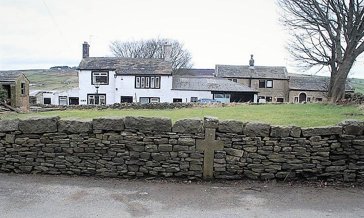
| Description | : | Quaker Cemetery in Main Street, Stanbury, West Yorkshire. Used by the Quakers between 1656 and 1718. Stone Cross inserted into front wall in 1980, inscribed with the years it was used and the number of people interred: 1656 1718 45 QUAKERS. Photo: |
frequently asked questions (FAQ):
-
Where is Main Street Friends Burial Ground at Stanbury?
Main Street Friends Burial Ground at Stanbury is located at Keighley, Metropolitan Borough of Bradford ,West Yorkshire ,England.
-
Main Street Friends Burial Ground at Stanbury cemetery's updated grave count on graveviews.com?
0 memorials
-
Where are the coordinates of the Main Street Friends Burial Ground at Stanbury?
Latitude: 53.8294690
Longitude: -1.9891640
Nearby Cemetories:
1. Haworth Cemetery
Haworth, Metropolitan Borough of Bradford, England
Coordinate: 53.8301460, -1.9679580
2. West Lane Baptist Chapel
Haworth, Metropolitan Borough of Bradford, England
Coordinate: 53.8324090, -1.9586480
3. St. Michael and All Angels Churchyard
Haworth, Metropolitan Borough of Bradford, England
Coordinate: 53.8311500, -1.9562350
4. Hall Green Baptist Chapel
Haworth, Metropolitan Borough of Bradford, England
Coordinate: 53.8285280, -1.9528130
5. Oakworth Crematorium
Keighley, Metropolitan Borough of Bradford, England
Coordinate: 53.8499320, -1.9661240
6. Christ Church Churchyard
Oakworth, Metropolitan Borough of Bradford, England
Coordinate: 53.8459200, -1.9549100
7. Oxenhope Cemetery
Oxenhope, Metropolitan Borough of Bradford, England
Coordinate: 53.8050500, -1.9652200
8. Oakworth Wesleyan Methodist Cemetery
Oakworth, Metropolitan Borough of Bradford, England
Coordinate: 53.8454920, -1.9493540
9. St. Mary the Virgin Churchyard
Oxenhope, Metropolitan Borough of Bradford, England
Coordinate: 53.8082633, -1.9556365
10. Slack Lane Baptist Cemetery
Oakworth, Metropolitan Borough of Bradford, England
Coordinate: 53.8527400, -1.9568800
11. Horkinstone Baptists Burial Ground
Metropolitan Borough of Bradford, England
Coordinate: 53.8050236, -1.9327888
12. Laycock Wesleyan Methodist Cemetery
Laycock, Metropolitan Borough of Bradford, England
Coordinate: 53.8651200, -1.9527500
13. St. John the Evangelist Churchyard
Ingrow, Metropolitan Borough of Bradford, England
Coordinate: 53.8552100, -1.9163280
14. St. John the Evangelist Churchyard
Cullingworth, Metropolitan Borough of Bradford, England
Coordinate: 53.8282300, -1.8991300
15. Friends Burial Ground at Calversike Hill
Kildwick, Craven District, England
Coordinate: 53.8661050, -1.9195670
16. Keighley Shared Churchyard
Keighley, Metropolitan Borough of Bradford, England
Coordinate: 53.8651000, -1.9095580
17. Denholme Shared Church
Denholme, Metropolitan Borough of Bradford, England
Coordinate: 53.8062745, -1.8949800
18. Denholme Methodist Chapelyard
Denholme, Metropolitan Borough of Bradford, England
Coordinate: 53.8050350, -1.8938640
19. Harden Rycroft Primitive Methodist Church
Keighley, Metropolitan Borough of Bradford, England
Coordinate: 53.8385220, -1.8830690
20. St Andrew Methodist Cemetery
Cowling, Craven District, England
Coordinate: 53.8830940, -2.0465580
21. Cowling Holy Trinity Churchyard
Cowling, Craven District, England
Coordinate: 53.8836542, -2.0473431
22. St. Thomas's Churchyard
Sutton-in-Craven, Craven District, England
Coordinate: 53.8937020, -1.9906290
23. Holy Trinity Churchyard
Cowling, Craven District, England
Coordinate: 53.8836930, -2.0502720
24. Holy Trinity Churchyard
Cowling, Craven District, England
Coordinate: 53.8837150, -2.0503150