
| Memorials | : | 0 |
| Location | : | Ruby, Chesterfield County, USA |
| Coordinate | : | 34.6734700, -80.2169380 |
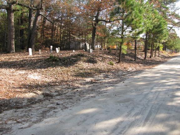
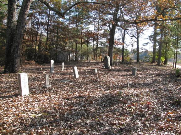
| Description | : | Directions: Take Highway 109 south from Ruby, S.C. Turn right on Woodward Mill Road (S-13-138). Bear left on Bo Melton Loop (S-13-138). Turn left on McNair Cemetery Road which is dirt. Cemetery is about a mile down on left. |
frequently asked questions (FAQ):
-
Where is McNair Family Cemetery?
McNair Family Cemetery is located at McNair Cemetery Road Ruby, Chesterfield County ,South Carolina ,USA.
-
McNair Family Cemetery cemetery's updated grave count on graveviews.com?
0 memorials
-
Where are the coordinates of the McNair Family Cemetery?
Latitude: 34.6734700
Longitude: -80.2169380
Nearby Cemetories:
1. White Oak Presbyterian Church Cemetery
Ruby, Chesterfield County, USA
Coordinate: 34.6838420, -80.1955870
2. Clanton Plains Baptist Church Cemetery
Ruby, Chesterfield County, USA
Coordinate: 34.6666410, -80.1897880
3. Sweet Home Missionary Baptist Church Cemetery
Ruby, Chesterfield County, USA
Coordinate: 34.6867220, -80.1862370
4. Watson Cemetery
Ruby, Chesterfield County, USA
Coordinate: 34.7093120, -80.2077910
5. Douglas Mill Baptist Church Cemetery
Ruby, Chesterfield County, USA
Coordinate: 34.6904940, -80.1658090
6. Cross Roads Baptist Church Cemetery
Ruby, Chesterfield County, USA
Coordinate: 34.7182999, -80.2386017
7. Campbell Family Cemetery
Chesterfield, Chesterfield County, USA
Coordinate: 34.6254210, -80.1894170
8. Fairview Baptist Church Cemetery
Mount Croghan, Chesterfield County, USA
Coordinate: 34.7000008, -80.2750015
9. Rock Springs Baptist Church Cemetery
Ruby, Chesterfield County, USA
Coordinate: 34.7338650, -80.1962580
10. Cross of Calvary Freewill Baptist Church
Mount Croghan, Chesterfield County, USA
Coordinate: 34.6518540, -80.2893920
11. Gulledge Cemetery
Ruby, Chesterfield County, USA
Coordinate: 34.7370540, -80.2192710
12. Douglass Cemetery
Chesterfield, Chesterfield County, USA
Coordinate: 34.6970650, -80.1429240
13. Mount Olive Missionary Baptist Church Cemetery
Chesterfield, Chesterfield County, USA
Coordinate: 34.6977490, -80.1425870
14. Bethel United Methodist Church Cemetery
Ruby, Chesterfield County, USA
Coordinate: 34.6229840, -80.1655590
15. Roscoe-Cassidy Cemetery
Campbell Crossroads, Chesterfield County, USA
Coordinate: 34.6272011, -80.1577988
16. Ruby Church of God Cemetery
Ruby, Chesterfield County, USA
Coordinate: 34.7406250, -80.2151300
17. Rocky Creek Baptist Church Cemetery
Chesterfield County, USA
Coordinate: 34.6439610, -80.2950450
18. Smith Cemetery
Ruby, Chesterfield County, USA
Coordinate: 34.7449670, -80.2004310
19. Smith Family Cemetery
Ruby, Chesterfield County, USA
Coordinate: 34.7451960, -80.1958290
20. Brantley Family Cemetery
Ruby, Chesterfield County, USA
Coordinate: 34.7468360, -80.1879220
21. Black Creek Baptist Church Cemetery
Jefferson, Chesterfield County, USA
Coordinate: 34.6934710, -80.3078040
22. Ruby Cemetery
Ruby, Chesterfield County, USA
Coordinate: 34.7447014, -80.1769028
23. Gulledge Cemetery
Mount Croghan, Chesterfield County, USA
Coordinate: 34.7516890, -80.2247430
24. Smith Cemetery
Ruby, Chesterfield County, USA
Coordinate: 34.7451040, -80.1773000