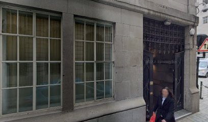
| Memorials | : | 101 |
| Location | : | London, City of London, England |
| Coordinate | : | 51.5141490, -0.0919390 |
| Description | : | The Hospital of St Thomas of Acre was the medieval London headquarters of the Knights of Saint Thomas. It was founded as a church in 1227 in the parish of St Mary Colechurch, birthplace of the order's patron saint, Saint Thomas Becket. In the 14th century and after it was the main headquarters of the military order. In 1512, the Worshipful Company of Mercers bought from the order a site by the church on which to build their hall, and in 1514 they formally became the patron to the order. In 1538, during the Protestant Reformation, the order was dissolved and the properties... Read More |
frequently asked questions (FAQ):
-
Where is Mercers Chapel?
Mercers Chapel is located at Ironmonger Ln Cheap, City of London ,Greater London , EC2V 8HEEngland.
-
Mercers Chapel cemetery's updated grave count on graveviews.com?
101 memorials
-
Where are the coordinates of the Mercers Chapel?
Latitude: 51.5141490
Longitude: -0.0919390
Nearby Cemetories:
1. St. Martin Pomary Churchyard
Cheap, City of London, England
Coordinate: 51.5145830, -0.0918610
2. All Hallows Churchyard
City of London, England
Coordinate: 51.5143760, -0.0930270
3. St Mary Colechurch (Defunct)
London, City of London, England
Coordinate: 51.5136110, -0.0911110
4. Saint Pancras Soper Lane (Defunct)
London, City of London, England
Coordinate: 51.5132830, -0.0918850
5. Church of Saint Mary Magdalen Milk Street
London, City of London, England
Coordinate: 51.5136110, -0.0930560
6. St. Benet Sherehog Churchyard (Defunct)
London, City of London, England
Coordinate: 51.5132700, -0.0912020
7. St Mary-le-Bow
London, City of London, England
Coordinate: 51.5137100, -0.0935517
8. St. Lawrence Jewry Churchyard
London, City of London, England
Coordinate: 51.5152340, -0.0924910
9. St Antholin's Church
London, City of London, England
Coordinate: 51.5126895, -0.0915805
10. St Mary Aldermary
London, City of London, England
Coordinate: 51.5127900, -0.0933800
11. Guildhall
London, City of London, England
Coordinate: 51.5158200, -0.0911380
12. All Hallows Churchyard
London, City of London, England
Coordinate: 51.5131130, -0.0948140
13. St Christopher le Stocks
London, City of London, England
Coordinate: 51.5142000, -0.0886000
14. St Mary Aldermanbury Churchyard
London, City of London, England
Coordinate: 51.5164830, -0.0930720
15. St Mildred Bread Street Church Demolished
London, City of London, England
Coordinate: 51.5123790, -0.0950740
16. Holy Trinity the Less Churchyard (Defunct)
London, City of London, England
Coordinate: 51.5119670, -0.0944820
17. St Mary Woolnoth Churchyard
London, City of London, England
Coordinate: 51.5127650, -0.0881070
18. St. John the Evangelist Churchyard
Bread Street, City of London, England
Coordinate: 51.5124910, -0.0954840
19. St Vedast Churchyard
London, City of London, England
Coordinate: 51.5149110, -0.0962350
20. St Albans Churchyard (Defunct)
London, City of London, England
Coordinate: 51.5166460, -0.0940880
21. Saint Mary Bothaw (Defunct)
London, City of London, England
Coordinate: 51.5114000, -0.0900800
22. Saint Swithin London Stone Churchyard
London, City of London, England
Coordinate: 51.5115800, -0.0894340
23. St. Leonard's Churchyard
Aldgate, City of London, England
Coordinate: 51.5152950, -0.0966580
24. St James Garlickhythe Churchyard
London, City of London, England
Coordinate: 51.5111070, -0.0937560

