
| Memorials | : | 1 |
| Location | : | Lehigh, Coal County, USA |
| Coordinate | : | 34.4402800, -96.2081200 |
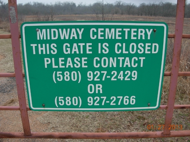
| Description | : | This cemetery is in a private pasture, with access restricted by fence and a locked gate with a sign that has contact information. The cemetery was started during the late 1800s and used to bury the dead in plots of land provided by the Midway and Lehigh communities. Midway was a black community, and Lehigh was a white community. But Midway Cemetery contains both black and white graves. It was located near the banks of Coal Creek south of Lehigh on Highway 75. Later, when the town moved further north, Lehigh moved most of their graves. |
frequently asked questions (FAQ):
-
Where is Midway Cemetery?
Midway Cemetery is located at Lehigh, Coal County ,Oklahoma ,USA.
-
Midway Cemetery cemetery's updated grave count on graveviews.com?
1 memorials
-
Where are the coordinates of the Midway Cemetery?
Latitude: 34.4402800
Longitude: -96.2081200
Nearby Cemetories:
1. Old Lehigh Cemetery
Lehigh, Coal County, USA
Coordinate: 34.4435997, -96.2164001
2. Lehigh Cemetery
Lehigh, Coal County, USA
Coordinate: 34.4775900, -96.2319400
3. Macedonia Cemetery
Atoka, Atoka County, USA
Coordinate: 34.4350000, -96.1447300
4. Valley View Cemetery
Atoka County, USA
Coordinate: 34.4068985, -96.2632980
5. Green Meadows Cemetery
Atoka, Atoka County, USA
Coordinate: 34.3983700, -96.1455630
6. Coal Creek Cemetery
Atoka, Atoka County, USA
Coordinate: 34.4563889, -96.1286111
7. Plainview Cemetery
Atoka County, USA
Coordinate: 34.3717003, -96.2118988
8. Calvary Cemetery
Phillips, Coal County, USA
Coordinate: 34.5121994, -96.2136002
9. Wards Chapel Cemetery
Atoka, Atoka County, USA
Coordinate: 34.3675003, -96.2497025
10. Standing Rock Cemetery
Atoka County, USA
Coordinate: 34.3863983, -96.2810974
11. Westview Cemetery
Atoka, Atoka County, USA
Coordinate: 34.3838420, -96.1331060
12. Confederate Cemetery
Atoka, Atoka County, USA
Coordinate: 34.3983002, -96.1164017
13. B Street Catholic Churchyard
Atoka, Atoka County, USA
Coordinate: 34.3863090, -96.1211550
14. B Street Cemetery
Atoka, Atoka County, USA
Coordinate: 34.3853615, -96.1194889
15. Green Hill Cemetery
Atoka, Atoka County, USA
Coordinate: 34.3817800, -96.1191150
16. Woodman Cemetery
Coalgate, Coal County, USA
Coordinate: 34.5341988, -96.1996994
17. Whitehall Cemetery
Atoka County, USA
Coordinate: 34.4166985, -96.3230972
18. Sealy Cemetery
Coal County, USA
Coordinate: 34.4775009, -96.3202972
19. Davis Cemetery
Coal County, USA
Coordinate: 34.4860992, -96.3321991
20. Tushka Cemetery
Tushka, Atoka County, USA
Coordinate: 34.3238983, -96.1707993
21. Boggy Bend Cemetery
Stringtown, Atoka County, USA
Coordinate: 34.4955556, -96.0775000
22. Stringtown Cemetery
Stringtown, Atoka County, USA
Coordinate: 34.4639015, -96.0625000
23. Coalgate Cemetery
Coalgate, Coal County, USA
Coordinate: 34.5628014, -96.2155991
24. Wells Street Cemetery
Atoka County, USA
Coordinate: 34.4668007, -96.0606003