
| Memorials | : | 9 |
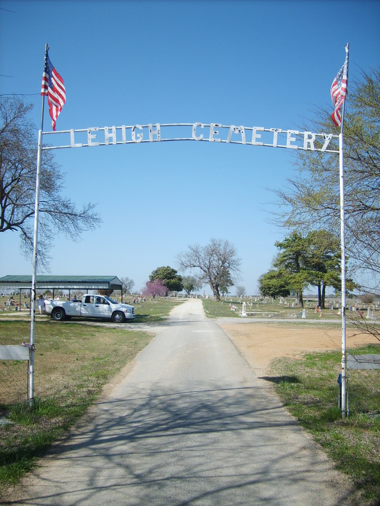
| Location | : | Lehigh, Coal County, USA |
| Coordinate | : | 34.4775900, -96.2319400 |
| Description | : | There is evidence this cemetery was here as early as the 1870-1880s. Part of it was a Catholic Cemetery called Fairview. In 1892, there was a mine explosion at Krebs, Oklahoma, in Pittsburg County which caused the mine to shut down. Somewhere between 100 and 200 people moved to the mines at Lehigh, causing that community to explode with growth. The cemetery also grew because graves were moved to Lehigh from the Midway Cemetery and people who had previously used the Calvary Cemetery began to use the one at Lehigh. The Fairview Cemetery also merged into Lehigh Cemetery. Many nationalities... Read More |
frequently asked questions (FAQ):
-
Where is Lehigh Cemetery?
Lehigh Cemetery is located at Lehigh, Coal County ,Oklahoma ,USA.
-
Lehigh Cemetery cemetery's updated grave count on graveviews.com?
8 memorials
-
Where are the coordinates of the Lehigh Cemetery?
Latitude: 34.4775900
Longitude: -96.2319400
Nearby Cemetories:
1. Old Lehigh Cemetery
Lehigh, Coal County, USA
Coordinate: 34.4435997, -96.2164001
2. Calvary Cemetery
Phillips, Coal County, USA
Coordinate: 34.5121994, -96.2136002
3. Midway Cemetery
Lehigh, Coal County, USA
Coordinate: 34.4402800, -96.2081200
4. Woodman Cemetery
Coalgate, Coal County, USA
Coordinate: 34.5341988, -96.1996994
5. Sealy Cemetery
Coal County, USA
Coordinate: 34.4775009, -96.3202972
6. Valley View Cemetery
Atoka County, USA
Coordinate: 34.4068985, -96.2632980
7. Davis Cemetery
Coal County, USA
Coordinate: 34.4860992, -96.3321991
8. Macedonia Cemetery
Atoka, Atoka County, USA
Coordinate: 34.4350000, -96.1447300
9. Coalgate Cemetery
Coalgate, Coal County, USA
Coordinate: 34.5628014, -96.2155991
10. Coal Creek Cemetery
Atoka, Atoka County, USA
Coordinate: 34.4563889, -96.1286111
11. Nixon Cemetery
Coalgate, Coal County, USA
Coordinate: 34.5345150, -96.3253070
12. Whitehall Cemetery
Atoka County, USA
Coordinate: 34.4166985, -96.3230972
13. Standing Rock Cemetery
Atoka County, USA
Coordinate: 34.3863983, -96.2810974
14. Green Meadows Cemetery
Atoka, Atoka County, USA
Coordinate: 34.3983700, -96.1455630
15. Plainview Cemetery
Atoka County, USA
Coordinate: 34.3717003, -96.2118988
16. Wards Chapel Cemetery
Atoka, Atoka County, USA
Coordinate: 34.3675003, -96.2497025
17. Keel Family Cemetery
Coal County, USA
Coordinate: 34.5064011, -96.3703003
18. Confederate Cemetery
Atoka, Atoka County, USA
Coordinate: 34.3983002, -96.1164017
19. Westview Cemetery
Atoka, Atoka County, USA
Coordinate: 34.3838420, -96.1331060
20. Boggy Bend Cemetery
Stringtown, Atoka County, USA
Coordinate: 34.4955556, -96.0775000
21. James Family Cemetery
Olney, Coal County, USA
Coordinate: 34.4617100, -96.3872100
22. B Street Catholic Churchyard
Atoka, Atoka County, USA
Coordinate: 34.3863090, -96.1211550
23. B Street Cemetery
Atoka, Atoka County, USA
Coordinate: 34.3853615, -96.1194889
24. Round Lake Cemetery
Centrahoma, Coal County, USA
Coordinate: 34.5778008, -96.3371964