
| Memorials | : | 0 |
| Location | : | Lexington, Henderson County, USA |
| Coordinate | : | 35.6134700, -88.5051910 |
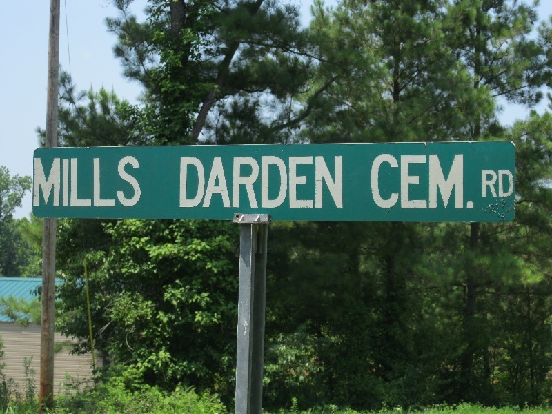
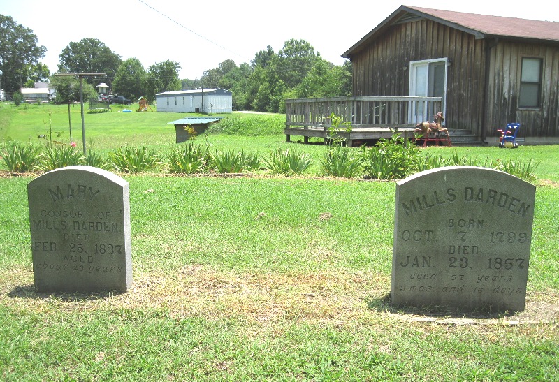
| Description | : | From the intersection of Mills Darden Rd. & TN-200 S, southwest of Lexington, where the Mills Darden's Historical Marker is located, travel northwest on Mills Darden Rd., going 1.7 mi., to a house on the north (right) side of the road. The cemetery is to the rear of the house, back near the wood-line. Although Mills and Mary Darden's grave markers are the only ones here, it has been reported that there were probably other people buried there, as well as some of Darden's slaves. The grave site had once been included in a plowed field on the... Read More |
frequently asked questions (FAQ):
-
Where is Mills Darden Cemetery?
Mills Darden Cemetery is located at Mills Darden Road Lexington, Henderson County ,Tennessee , 38351USA.
-
Mills Darden Cemetery cemetery's updated grave count on graveviews.com?
0 memorials
-
Where are the coordinates of the Mills Darden Cemetery?
Latitude: 35.6134700
Longitude: -88.5051910
Nearby Cemetories:
1. Chapel Hill Baptist Church Cemetery
Lexington, Henderson County, USA
Coordinate: 35.5983900, -88.4864500
2. Beech Grove Cemetery
Huron, Henderson County, USA
Coordinate: 35.6332390, -88.5187900
3. Cooper Cemetery
Henderson County, USA
Coordinate: 35.5924988, -88.4935989
4. New Bethel Cemetery
Lexington, Henderson County, USA
Coordinate: 35.6244030, -88.4800220
5. Holly Springs Cemetery
Huron, Henderson County, USA
Coordinate: 35.6428020, -88.5085560
6. Browns Pentecostal Church Cemetery
Huron, Henderson County, USA
Coordinate: 35.5791010, -88.5182410
7. Old Bethel Church Cemetery
Lexington, Henderson County, USA
Coordinate: 35.6393610, -88.4722500
8. Old Hepzibah Cemetery
Blue Goose, Henderson County, USA
Coordinate: 35.6507988, -88.4978027
9. Mullins Cemetery
Lexington, Henderson County, USA
Coordinate: 35.6078360, -88.4533310
10. McHaney Cemetery
Luray, Henderson County, USA
Coordinate: 35.6045110, -88.5569110
11. Emmanuel Baptist Church Cemetery
Huron, Henderson County, USA
Coordinate: 35.6201180, -88.5653430
12. Palestine Church Cemetery
Lexington, Henderson County, USA
Coordinate: 35.5904470, -88.4478410
13. Buckley Cemetery
Luray, Henderson County, USA
Coordinate: 35.5826780, -88.5605090
14. Phelps Family Cemetery
Huron, Henderson County, USA
Coordinate: 35.5573500, -88.5022250
15. Priddy Graveyard
Lexington, Henderson County, USA
Coordinate: 35.5648260, -88.4688010
16. Scott Cemetery
Lexington, Henderson County, USA
Coordinate: 35.6331110, -88.4388890
17. Nebo Church Cemetery
Henderson County, USA
Coordinate: 35.6400540, -88.5689960
18. Garrett Cemetery
Huron, Henderson County, USA
Coordinate: 35.5554150, -88.4938810
19. Crook Cemetery
Huron, Henderson County, USA
Coordinate: 35.5536240, -88.5124970
20. Middlefork Road Church Cemetery
Luray, Henderson County, USA
Coordinate: 35.5573190, -88.5344410
21. Palestine Pentecostal Church Cemetery
Lexington, Henderson County, USA
Coordinate: 35.5908080, -88.4342830
22. Cooper's Grove Church Cemetery
Lexington, Henderson County, USA
Coordinate: 35.6459320, -88.4398000
23. Hendrick Graveyard
Huron, Henderson County, USA
Coordinate: 35.5511000, -88.5320000
24. Sand Ridge Church Cemetery
Lexington, Henderson County, USA
Coordinate: 35.6800760, -88.4800950