
| Memorials | : | 0 |
| Location | : | Salem Township, Jefferson County, USA |
| Coordinate | : | 40.4075012, -80.8182983 |
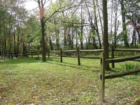
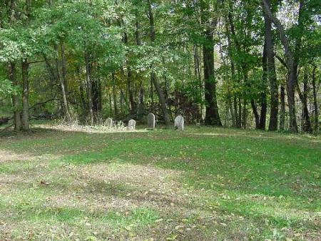
| Description | : | The cemetery is located about 1400 feet south of Ohio State Route 646 about 0.3 miles west of its intersection with Bonar Road (Township Road 217). The cemetery is located in Salem Township, Jefferson County, Ohio, and is # 6068 (Mount Hope Methodist Cemetery / Mount Hope Cemetery) in “Ohio Cemeteries 1803-2003”, compiled by the Ohio Genealogical Society. The U.S. Geological Survey (USGS) Geographic Names Information System (GNIS) feature ID for the cemetery is 1043569 (Mount Hope Cemetery). |
frequently asked questions (FAQ):
-
Where is Mount Hope Cemetery?
Mount Hope Cemetery is located at Ohio State Route 646 Salem Township, Jefferson County ,Ohio , 43910USA.
-
Mount Hope Cemetery cemetery's updated grave count on graveviews.com?
0 memorials
-
Where are the coordinates of the Mount Hope Cemetery?
Latitude: 40.4075012
Longitude: -80.8182983
Nearby Cemetories:
1. Leas Cemetery
Salem Township, Jefferson County, USA
Coordinate: 40.4106710, -80.8383720
2. Quaker Cemetery
Richmond, Jefferson County, USA
Coordinate: 40.4112680, -80.7883450
3. Holy Family Hermitage Cemetery
Bloomingdale, Jefferson County, USA
Coordinate: 40.3840650, -80.8243020
4. Queen of All Saints Cemetery
Bloomingdale, Jefferson County, USA
Coordinate: 40.3841050, -80.8094450
5. Wallace Cemetery
Salem Township, Jefferson County, USA
Coordinate: 40.4391170, -80.8176500
6. Annapolis Lutheran Cemetery
Annapolis, Jefferson County, USA
Coordinate: 40.4130307, -80.8608010
7. Annapolis Cemetery
Salem Township, Jefferson County, USA
Coordinate: 40.4100583, -80.8636942
8. Richmond Union Cemetery
Richmond, Jefferson County, USA
Coordinate: 40.4289017, -80.7763977
9. Carne Cemetery
Salem Township, Jefferson County, USA
Coordinate: 40.4089012, -80.7667007
10. Pine Run Cemetery
Unionport, Jefferson County, USA
Coordinate: 40.3703003, -80.8407974
11. Sproat Cemetery
Harrison County, USA
Coordinate: 40.4039001, -80.8719025
12. Methodist-Episcopal Cemetery
Richmond, Jefferson County, USA
Coordinate: 40.4317460, -80.7709400
13. Richmond United Presbyterian Cemetery
Salem Township, Jefferson County, USA
Coordinate: 40.4310989, -80.7680969
14. Unionport Cemetery
Unionport, Jefferson County, USA
Coordinate: 40.3650440, -80.8496090
15. East Springfield Cemetery
East Springfield, Jefferson County, USA
Coordinate: 40.4490890, -80.8592080
16. Buffalo Hill Cemetery
Harrison County, USA
Coordinate: 40.3911018, -80.8886032
17. Davidson Cemetery
Springfield Township, Jefferson County, USA
Coordinate: 40.4441986, -80.8818970
18. Wheeler Cemetery
Hopedale, Harrison County, USA
Coordinate: 40.3632420, -80.8786110
19. Bloomingdale Cemetery
Bloomingdale, Jefferson County, USA
Coordinate: 40.3418110, -80.8134230
20. Two Ridges Cemetery
Wintersville, Jefferson County, USA
Coordinate: 40.3944016, -80.7328033
21. Miller Cemetery
Springfield Township, Jefferson County, USA
Coordinate: 40.4509580, -80.8913850
22. Blue Ridge Cemetery
Hopedale, Harrison County, USA
Coordinate: 40.3671989, -80.8949966
23. Andrews Cemetery
Ross Township, Jefferson County, USA
Coordinate: 40.4674530, -80.7682190
24. Montgomery Cemetery
East Springfield, Jefferson County, USA
Coordinate: 40.4776540, -80.8347600