
| Memorials | : | 0 |
| Location | : | Placerville, El Dorado County, USA |
| Coordinate | : | 38.7894490, -120.7380720 |
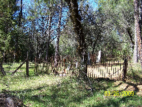
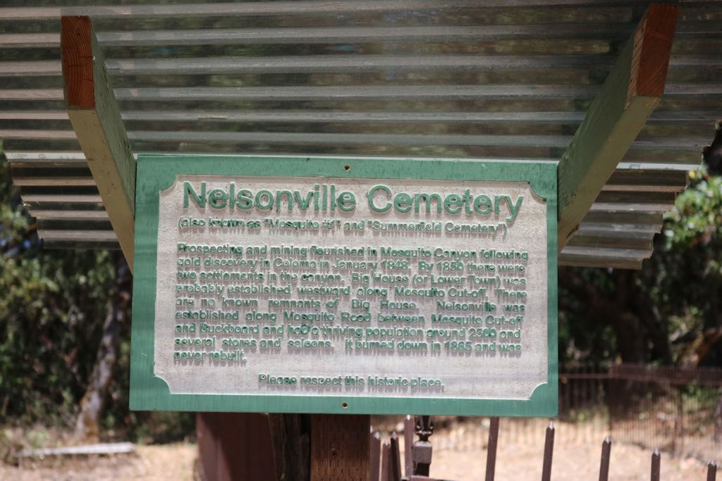
| Description | : | Nelsonville is a historic cemetery located in El Dorado County, California near Placerville. It is in poor condition with minimal maintenance performed by local residents. This cemetery is located on private property, however, it can be accessed from La Paz Road. For additional information, contact Cemetery Administrator, County of El Dorado, Department of Transportation, 360 Fair Lane, Placerville, CA 95667. In addition to the markers or known burials, there are approximately 10 unidentified graves which, according to legend, include "five Dance Hall Girls". The origin of this legend is unknown. Nelsonville was established in the 1850s and 1860s to support logging and... Read More |
frequently asked questions (FAQ):
-
Where is Nelsonville Cemetery?
Nelsonville Cemetery is located at La Paz Road Placerville, El Dorado County ,California ,USA.
-
Nelsonville Cemetery cemetery's updated grave count on graveviews.com?
0 memorials
-
Where are the coordinates of the Nelsonville Cemetery?
Latitude: 38.7894490
Longitude: -120.7380720
Nearby Cemetories:
1. Andre Family Cemetery
Placerville, El Dorado County, USA
Coordinate: 38.7822250, -120.7466710
2. Dickinson Family Cemetery
Placerville, El Dorado County, USA
Coordinate: 38.7970450, -120.7269010
3. Blairs-Winkelman Cemetery
Camino, El Dorado County, USA
Coordinate: 38.7547140, -120.7098510
4. Jacquier Family Cemetery
Placerville, El Dorado County, USA
Coordinate: 38.7424420, -120.7602750
5. Smiths Flat Cemetery
Placerville, El Dorado County, USA
Coordinate: 38.7325287, -120.7552414
6. Kelsey Cemetery
Kelsey, El Dorado County, USA
Coordinate: 38.7949791, -120.8200073
7. Chili Bar Toll House Cemetery
Placerville, El Dorado County, USA
Coordinate: 38.7700530, -120.8177660
8. Uppertown Cemetery
Placerville, El Dorado County, USA
Coordinate: 38.7320900, -120.7890625
9. County Hospital Cemetery
Placerville, El Dorado County, USA
Coordinate: 38.7342796, -120.8028488
10. Methodist Episcopal Federated Cemetery
Placerville, El Dorado County, USA
Coordinate: 38.7283287, -120.7942200
11. Saint Patrick Cemetery
Placerville, El Dorado County, USA
Coordinate: 38.7327995, -120.8047638
12. Camino Cemetery
Camino, El Dorado County, USA
Coordinate: 38.7450981, -120.6564407
13. Boles Family Cemetery
Placerville, El Dorado County, USA
Coordinate: 38.7309860, -120.8069580
14. Placerville Union Cemetery
Placerville, El Dorado County, USA
Coordinate: 38.7317390, -120.8084106
15. Jewish Pioneer Cemetery
Placerville, El Dorado County, USA
Coordinate: 38.7299500, -120.8091965
16. Old Saint Patricks Cemetery
Placerville, El Dorado County, USA
Coordinate: 38.7249107, -120.8024673
17. Old Placerville City Cemetery
Placerville, El Dorado County, USA
Coordinate: 38.7258987, -120.8059464
18. Middletown Cemetery
Placerville, El Dorado County, USA
Coordinate: 38.7358704, -120.8301010
19. Westwood Hills Memorial Park Pet Cemetery
Placerville, El Dorado County, USA
Coordinate: 38.7365210, -120.8323130
20. Westwood Hills Memorial Park
Placerville, El Dorado County, USA
Coordinate: 38.7367363, -120.8326035
21. Weberville Cemetery
Placerville, El Dorado County, USA
Coordinate: 38.7024170, -120.7901000
22. Newtown Cemetery
Newtown, El Dorado County, USA
Coordinate: 38.7050410, -120.6787310
23. Missouri Flat Cemetery
Placerville, El Dorado County, USA
Coordinate: 38.7157360, -120.8403400
24. Odd Fellows Cemetery
Diamond Springs, El Dorado County, USA
Coordinate: 38.6963882, -120.8151932