| Memorials | : | 0 |
| Location | : | Appleton Roebuck, Selby District, England |
| Coordinate | : | 53.8525000, -1.1561110 |
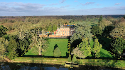
| Description | : | The Priory was closed during the Dissolution in the mid 1500s. It was subsequently destroyed and built over with more modern buildings. The GPS location in approximate as the exact site of the original Priory is unknown. |
frequently asked questions (FAQ):
-
Where is Nun Appleton Priory?
Nun Appleton Priory is located at Appleton Roebuck, Selby District ,North Yorkshire ,England.
-
Nun Appleton Priory cemetery's updated grave count on graveviews.com?
0 memorials
-
Where are the coordinates of the Nun Appleton Priory?
Latitude: 53.8525000
Longitude: -1.1561110
Nearby Cemetories:
1. All Saints Churchyard
Ryther, Selby District, England
Coordinate: 53.8478600, -1.1576100
2. St John Churchyard
Acaster Selby, Selby District, England
Coordinate: 53.8614750, -1.1283740
3. All Saints Churchyard
Appleton Roebuck, Selby District, England
Coordinate: 53.8734600, -1.1580870
4. Rythergate Cemetery
Cawood, Selby District, England
Coordinate: 53.8356000, -1.1347700
5. All Saints Churchyard
Bolton Percy, Selby District, England
Coordinate: 53.8649780, -1.1929000
6. All Saints Churchyard
Cawood, Selby District, England
Coordinate: 53.8331970, -1.1235660
7. St Helen Churchyard
Stillingfleet, Selby District, England
Coordinate: 53.8618710, -1.0994760
8. St John the Baptist Churchyard Extension
Kirkby Wharfe, Selby District, England
Coordinate: 53.8602100, -1.2321200
9. St Paul Churchyard
Colton, Selby District, England
Coordinate: 53.8964660, -1.1773770
10. St John the Baptist Churchyard
Kirkby Wharfe, Selby District, England
Coordinate: 53.8627400, -1.2320400
11. St Mary the Virgin Churchyard
Church Fenton, Selby District, England
Coordinate: 53.8243100, -1.2203500
12. All Saints Churchyard
Wistow, Selby District, England
Coordinate: 53.8134750, -1.1014755
13. Moor Lane Burial Ground
Copmanthorpe, York Unitary Authority, England
Coordinate: 53.9096890, -1.1449400
14. St. Mary's Churchyard
Riccall, Selby District, England
Coordinate: 53.8330620, -1.0601630
15. St Matthew Churchyard
Naburn, York Unitary Authority, England
Coordinate: 53.9009520, -1.0899200
16. Holy Trinity Churchyard
Acaster Malbis, York Unitary Authority, England
Coordinate: 53.9052480, -1.0975170
17. St Giles Churchyard
Copmanthorpe, York Unitary Authority, England
Coordinate: 53.9149240, -1.1410420
18. St James Churchyard
Bilbrough, Selby District, England
Coordinate: 53.9119110, -1.1945130
19. Holy Trinity Churchyard
Barkston Ash, Selby District, England
Coordinate: 53.8189530, -1.2547620
20. St. Helen's Churchyard
Escrick, Selby District, England
Coordinate: 53.8805200, -1.0460990
21. St Mary the Virgin Churchyard
Tadcaster, Selby District, England
Coordinate: 53.8852300, -1.2624100
22. Inghamite Chapel
Tadcaster, Selby District, England
Coordinate: 53.8843580, -1.2644470
23. Tadcaster Cemetery
Tadcaster, Selby District, England
Coordinate: 53.8808880, -1.2727280
24. St Mary Churchyard
Askham Richard, York Unitary Authority, England
Coordinate: 53.9254100, -1.1836800

