
| Memorials | : | 0 |
| Location | : | Forest Park, Clayton County, USA |
| Coordinate | : | 33.5943350, -84.3663310 |
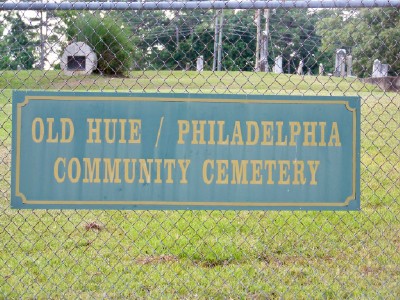
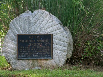
| Description | : | This cemetery is located at the north-west corner of the intersection of Ash and Melrose Streets. |
frequently asked questions (FAQ):
-
Where is Old Huie-Philadelphia Community Cemetery?
Old Huie-Philadelphia Community Cemetery is located at North-west corner of Ash Street and Melrose Drive Forest Park, Clayton County ,Georgia ,USA.
-
Old Huie-Philadelphia Community Cemetery cemetery's updated grave count on graveviews.com?
0 memorials
-
Where are the coordinates of the Old Huie-Philadelphia Community Cemetery?
Latitude: 33.5943350
Longitude: -84.3663310
Nearby Cemetories:
1. Philadelphia Presbyterian Church Cemetery
Forest Park, Clayton County, USA
Coordinate: 33.5900002, -84.3786011
2. Saint Augustine of Canterbury Episcopal Church Col
Morrow, Clayton County, USA
Coordinate: 33.5844150, -84.3504820
3. Carver Memorial Gardens
Jonesboro, Clayton County, USA
Coordinate: 33.5797005, -84.3792038
4. Forest Park City Cemetery
Forest Park, Clayton County, USA
Coordinate: 33.6193190, -84.3574260
5. Forest Park Primitive Baptist Church Cemetery
Forest Park, Clayton County, USA
Coordinate: 33.6196230, -84.3568800
6. Sherwood Memorial Park and Mausoleum
Jonesboro, Clayton County, USA
Coordinate: 33.5673300, -84.3718200
7. Jones Memorial Cemetery
Forest Park, Clayton County, USA
Coordinate: 33.6204400, -84.3816900
8. Morrow Cemetery
Morrow, Clayton County, USA
Coordinate: 33.5774994, -84.3368988
9. Forest Grove Cemetery
Forest Park, Clayton County, USA
Coordinate: 33.6231003, -84.3546982
10. William's Chapel
Clayton County, USA
Coordinate: 33.5988930, -84.3255620
11. Old Elam Primitive Baptist Church Cemetery
Forest Park, Clayton County, USA
Coordinate: 33.6271900, -84.3501500
12. Mathalama AME Church Cemetery
Morrow, Clayton County, USA
Coordinate: 33.6031750, -84.3212440
13. Travelers Rest Missionary Baptist Church Cemetery
Morrow, Clayton County, USA
Coordinate: 33.5996640, -84.3197970
14. Smith Family Cemetery
Riverdale, Clayton County, USA
Coordinate: 33.5510720, -84.3741330
15. Riverdale First United Methodist Church Cemetery
Riverdale, Clayton County, USA
Coordinate: 33.5810100, -84.4169900
16. Rock Springs Cemetery
Clayton County, USA
Coordinate: 33.6399994, -84.3656006
17. Forest Hills Memorial Gardens
Forest Park, Clayton County, USA
Coordinate: 33.6411110, -84.3641670
18. Mount Zion Cemetery
Morrow, Clayton County, USA
Coordinate: 33.5614014, -84.3214035
19. Riverdale Baptist Cemetery
Riverdale, Clayton County, USA
Coordinate: 33.5685270, -84.4184410
20. Pope Family Burial Ground
Clayton County, USA
Coordinate: 33.6300556, -84.4111778
21. King Cemetery
Riverdale, Clayton County, USA
Coordinate: 33.5828018, -84.4293976
22. Norton Family Cemetery
College Park, Clayton County, USA
Coordinate: 33.6072480, -84.4352960
23. Tanners Road Baptist Church Cemetery
Conley, Clayton County, USA
Coordinate: 33.6316986, -84.3110962
24. Babb Cemetery
Jonesboro, Clayton County, USA
Coordinate: 33.5348170, -84.3737460