
| Memorials | : | 2 |
| Location | : | Prairieville, Rice County, USA |
| Coordinate | : | 44.2841680, -93.1903270 |
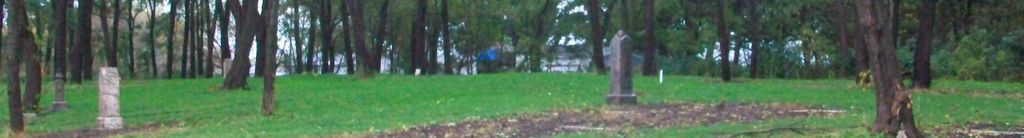
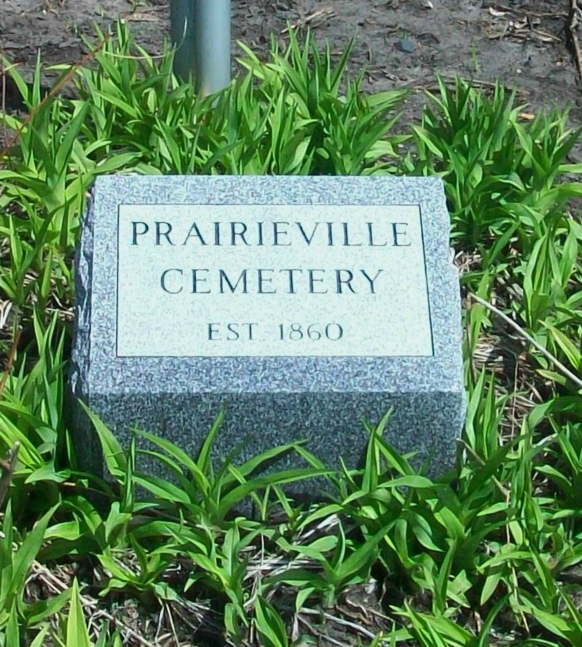
| Description | : | I drove past this Cemetery lots of times, but it was so heavily grown over I did not see it. In early Sept. I seen some poeple cutting grass and stuff, and wow tombstones! I did reserch and found it was Old Prairieville Cemetery. Abandoned for a long time. most stones are fallen over, but almost all are readable! It is east of Faribault on MN-60 on the north side of the hwy. Please do not take the location on the map as the right one I am just guessing. I will go back and get it latter, but it... Read More |
frequently asked questions (FAQ):
-
Where is Old Prairieville Cemetery?
Old Prairieville Cemetery is located at Prairieville, Rice County ,Minnesota ,USA.
-
Old Prairieville Cemetery cemetery's updated grave count on graveviews.com?
1 memorials
-
Where are the coordinates of the Old Prairieville Cemetery?
Latitude: 44.2841680
Longitude: -93.1903270
Nearby Cemetories:
1. Cannon City Cemetery
Cannon City, Rice County, USA
Coordinate: 44.3232040, -93.2098083
2. Faribault Regional Center East Cemetery
Walcott, Rice County, USA
Coordinate: 44.2824783, -93.2493744
3. Richland Union Cemetery
Faribault, Rice County, USA
Coordinate: 44.2405340, -93.1567680
4. Woodman Cemetery
Faribault, Rice County, USA
Coordinate: 44.2649994, -93.2556000
5. Faribault Regional Center West Cemetery
Walcott, Rice County, USA
Coordinate: 44.2802530, -93.2628560
6. Prairieville United Methodist Cemetery
Faribault, Rice County, USA
Coordinate: 44.2833786, -93.1132278
7. Meadow Ridge Memorial Park
Faribault, Rice County, USA
Coordinate: 44.2708015, -93.2696991
8. Cathedral of our Merciful Savior Columbarium
Faribault, Rice County, USA
Coordinate: 44.2977150, -93.2698560
9. Cemetery of the Good Shepherd
Faribault, Rice County, USA
Coordinate: 44.3147200, -93.2611080
10. Denison Cemetery
Faribault, Rice County, USA
Coordinate: 44.2472000, -93.2628021
11. Eklund Cemetery
Rice County, USA
Coordinate: 44.2182999, -93.1772003
12. Saint Edwards Catholic Cemetery
Epsom, Rice County, USA
Coordinate: 44.2413010, -93.1164130
13. Saint Johns United Church of Christ Cemetery
Faribault, Rice County, USA
Coordinate: 44.3120728, -93.1027679
14. Saint Lawrence Cemetery
Faribault, Rice County, USA
Coordinate: 44.3205986, -93.2739029
15. Oak Ridge Cemetery
Faribault, Rice County, USA
Coordinate: 44.3222008, -93.2742004
16. Richland Cemetery
Rice County, USA
Coordinate: 44.2182999, -93.1425018
17. Maple Lawn Cemetery
Faribault, Rice County, USA
Coordinate: 44.2886009, -93.2972031
18. Rice County Poor Farm Cemetery
Faribault, Rice County, USA
Coordinate: 44.2760506, -93.3032074
19. North Grove Cemetery
Faribault, Rice County, USA
Coordinate: 44.3519402, -93.2572174
20. Calvary Cemetery
Faribault, Rice County, USA
Coordinate: 44.2853012, -93.3127975
21. Epsom Pioneer Cemetery
Epsom, Rice County, USA
Coordinate: 44.2610730, -93.0558130
22. Valley Grove Cemetery
Nerstrand, Rice County, USA
Coordinate: 44.3619000, -93.1011000
23. Greenwood Cemetery
Faribault, Rice County, USA
Coordinate: 44.2116600, -93.0913600
24. Union Cemetery
Medford, Steele County, USA
Coordinate: 44.1893000, -93.2439400