
| Memorials | : | 0 |
| Location | : | Onewhero, Waikato District, New Zealand |
| Website | : | www.waikatodistrict.govt.nz/services-facilities/cemeteries/cemeteries-database |
| Coordinate | : | -37.3158900, 174.9104900 |
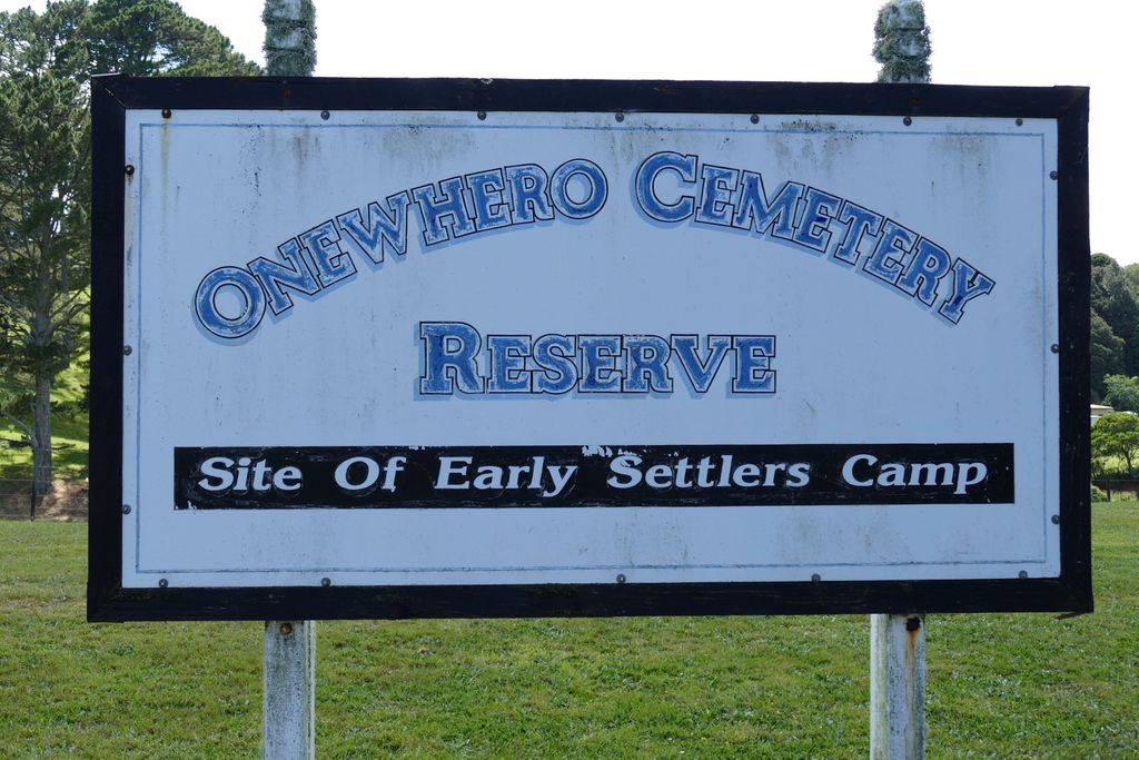
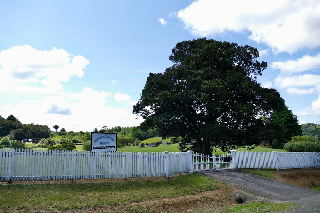
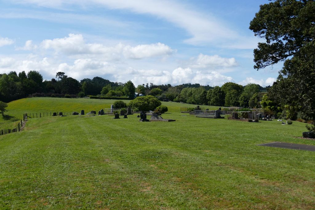
| Description | : | The setting is a rural farming area on the former Onewhero Settlers' Camp south of the Waikato River and east of the river mouth. The cemetery is fairly flat but drops off at the boundaries. The driveway is concreted and gated from the road extending into the cemetery by approximately 15 meters. The cemetery is well maintained with a large tree to provide some shade in summer. There is no water source nor seating present (December 2019). The earliest headstone is William John Young (1924). The cemetery is still in use today with plenty of space for more burials. |
frequently asked questions (FAQ):
-
Where is Onewhero Cemetery?
Onewhero Cemetery is located at Kaipo Flats Road Onewhero, Waikato District ,Waikato , 2697New Zealand.
-
Onewhero Cemetery cemetery's updated grave count on graveviews.com?
0 memorials
-
Where are the coordinates of the Onewhero Cemetery?
Latitude: -37.3158900
Longitude: 174.9104900
Nearby Cemetories:
1. Alexandra Redoubt Cemetery
Tuakau, Waikato District, New Zealand
Coordinate: -37.2858200, 174.9419600
2. Tuakau Cemetery
Tuakau, Waikato District, New Zealand
Coordinate: -37.2844420, 174.9465660
3. Manutahi Urupā
Port Waikato, Waikato District, New Zealand
Coordinate: -37.3337939, 174.8210091
4. Tekohanga Urupā
Port Waikato, Waikato District, New Zealand
Coordinate: -37.3314940, 174.8085230
5. Opuatia Urupā
Opuatia, Auckland Council, New Zealand
Coordinate: -37.3983460, 174.9893180
6. Pukekohe Public Cemetery
Pukekohe, Auckland Council, New Zealand
Coordinate: -37.2106400, 174.8974900
7. Pokeno Old Soldiers Cemetery
Pokeno, Waikato District, New Zealand
Coordinate: -37.2386120, 175.0094760
8. Pokeno Cemetery
Pokeno, Waikato District, New Zealand
Coordinate: -37.2364600, 175.0215400
9. Pukekohe Catholic Cemetery
Pukekohe, Auckland Council, New Zealand
Coordinate: -37.1951510, 174.9014640
10. Mercer Cemetery
Mercer, Waikato District, New Zealand
Coordinate: -37.2764860, 175.0578300
11. Pukekohe East Cemetery
Pukekohe East, Auckland Council, New Zealand
Coordinate: -37.1883500, 174.9459000
12. Heights Park Cemetery
Paerata, Auckland Council, New Zealand
Coordinate: -37.1781928, 174.8938836
13. St Brides Church of England Cemetery
Mauku, Auckland Council, New Zealand
Coordinate: -37.2011260, 174.8120370
14. Mauku Cemetery
Mauku, Auckland Council, New Zealand
Coordinate: -37.2011420, 174.8109100
15. St. Peter's in the Forest Anglican Cemetery
Bombay, Auckland Council, New Zealand
Coordinate: -37.1869100, 174.9914100
16. Glen Murray Cemetery
Glen Murray, Waikato District, New Zealand
Coordinate: -37.4551820, 174.9591310
17. Bombay Presbyterian Church Cemetery
Bombay, Auckland Council, New Zealand
Coordinate: -37.1790700, 174.9826900
18. Waiuku Cemetery
Waiuku, Auckland Council, New Zealand
Coordinate: -37.2612630, 174.7346520
19. Oraeroa Urupā
Port Waikato, Waikato District, New Zealand
Coordinate: -37.3913670, 174.7257830
20. Mauku Historical Cemetery
Mauku, Auckland Council, New Zealand
Coordinate: -37.1743690, 174.7951870
21. Tahuna Pa Road Urupā
Waiuku, Auckland Council, New Zealand
Coordinate: -37.2290900, 174.7080100
22. Pratt's Road Catholic Cemetery
Ramarama, Auckland Council, New Zealand
Coordinate: -37.1425500, 174.9871300
23. Ararimu Schoolhouse Cemetery
Ararimu, Auckland Council, New Zealand
Coordinate: -37.1448376, 175.0359288
24. Rangiriri Cemetery
Rangiriri, Waikato District, New Zealand
Coordinate: -37.4251670, 175.1283410