
| Memorials | : | 0 |
| Location | : | Randolph County, USA |
| Coordinate | : | 39.3712360, -92.5668110 |
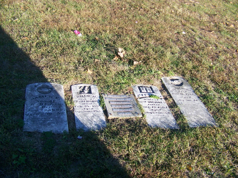
| Description | : | The original location of the Nichols Cemetery is in T53 R15 S23 on the west side of CR 2435 south of Rt BB. Four headstones were moved from this cemetery to Mt Salem Cemetery about a mile north of here. Memorials have been created for them in Mt Salem. William Pinckney Nichols, 1797-1884 #67445930 Martha (Cannon) Nichols, 1804-1864 #67446968 James E Nichols, 1879-1882 #67447027 Willie H Nichols, 1877-1879 #67447143 Two footstones still in place were found, one for James E Nichols and the other looked to have the initials G N, which doesn't match any of the stones which were moved. In... Read More |
frequently asked questions (FAQ):
-
Where is Original Nichols Cemetery?
Original Nichols Cemetery is located at Randolph County ,Missouri ,USA.
-
Original Nichols Cemetery cemetery's updated grave count on graveviews.com?
0 memorials
-
Where are the coordinates of the Original Nichols Cemetery?
Latitude: 39.3712360
Longitude: -92.5668110


Nearby Cemetories:
1. Jackson Family Cemetery
Huntsville, Randolph County, USA
Coordinate: 39.3759810, -92.5692600
2. Charles Barron Cemetery
Randolph County, USA
Coordinate: 39.3805710, -92.5589660
3. Mount Salem Cemetery
Huntsville, Randolph County, USA
Coordinate: 39.3890200, -92.5688200
4. Oliver Cemetery
Randolph County, USA
Coordinate: 39.3871600, -92.5831100
5. Freeman Cemetery
Randolph County, USA
Coordinate: 39.3476470, -92.5616940
6. Bagby Cemetery
Huntsville, Randolph County, USA
Coordinate: 39.3474998, -92.5610962
7. Fullington Cemetery
Randolph County, USA
Coordinate: 39.3919730, -92.5837650
8. Patrick Robertson Cemetery
Randolph County, USA
Coordinate: 39.3418470, -92.5756330
9. Sweet Springs Baptist Church Cemetery
Huntsville, Randolph County, USA
Coordinate: 39.3816500, -92.5259500
10. John Atterbury Farm Cemetery
Mount Airy, Randolph County, USA
Coordinate: 39.3833620, -92.6098600
11. Collins Family Cemetery
Randolph County, USA
Coordinate: 39.3574860, -92.5243130
12. Christian Family Cemetery
Randolph County, USA
Coordinate: 39.3500630, -92.5181620
13. Barron Cemetery
Higbee, Randolph County, USA
Coordinate: 39.3640470, -92.5080860
14. Mathis Cemetery
Huntsville, Randolph County, USA
Coordinate: 39.3806380, -92.6250540
15. Nicholas Dysart Cemetery
Randolph County, USA
Coordinate: 39.3302260, -92.5969630
16. Burton-Burk Cemetery
Clifton Hill, Randolph County, USA
Coordinate: 39.4152590, -92.5930630
17. Hurt Cemetery
Mount Airy, Randolph County, USA
Coordinate: 39.3720890, -92.6300010
18. Hagar Cemetery
Huntsville, Randolph County, USA
Coordinate: 39.4049988, -92.5130997
19. Old Mount Airy-Stark Cemetery
Randolph County, USA
Coordinate: 39.3760700, -92.6418100
20. Ebenezer Cemetery
Randolph County, USA
Coordinate: 39.3102240, -92.5579520
21. Elijah Burton Cemetery
Randolph County, USA
Coordinate: 39.3189200, -92.5249690
22. Whitmore Cemetery
Higbee, Randolph County, USA
Coordinate: 39.3088989, -92.5382996
23. Henry Austin Cemetery
Huntsville, Randolph County, USA
Coordinate: 39.4365180, -92.5434960
24. Goodman Cemetery
Mount Airy, Randolph County, USA
Coordinate: 39.3629680, -92.6539190