
| Memorials | : | 0 |
| Location | : | Pendock, Malvern Hills District, England |
| Website | : | www.visitchurches.org.uk/visit/church-listing/the-church-pendock.html |
| Coordinate | : | 52.0015108, -2.2678653 |
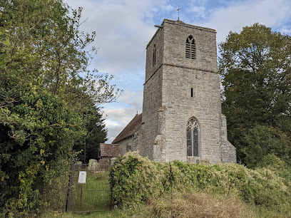
| Description | : | Pendock church is seen standing proud above the motorway to Ross-on-Wye. Earthworks in fields north of the church mark the site of a medieval village and probably the de Pendocks' manor house. Much of this charming church is Norman, although the tenth-century font suggests an even earlier building; in the fourteenth century new windows were added, and the west tower was built. There are lovely sixteenth-century pews and Jacobean communion rails. It is thought that the famous English composer Sir Edward Elgar may once have played the lovely little Georgian organ inside. (from https://www.visitchurches.org.uk/visit/church-listing/the-church-pendock.html) |
frequently asked questions (FAQ):
-
Where is Pendock Churchyard?
Pendock Churchyard is located at Pendock, Malvern Hills District ,Worcestershire ,England.
-
Pendock Churchyard cemetery's updated grave count on graveviews.com?
0 memorials
-
Where are the coordinates of the Pendock Churchyard?
Latitude: 52.0015108
Longitude: -2.2678653
Nearby Cemetories:
1. Pendock Old Church
Pendock, Malvern Hills District, England
Coordinate: 52.0014720, -2.2679110
2. St Faith Churchyard
Berrow, Malvern Hills District, England
Coordinate: 52.0065770, -2.3018720
3. St. Peter and St. Paul Churchyard
Birtsmorton, Malvern Hills District, England
Coordinate: 52.0176100, -2.2912600
4. St. Mary's Churchyard
Longdon, Malvern Hills District, England
Coordinate: 52.0244900, -2.2370600
5. St. Gregory Churchyard
Castlemorton, Malvern Hills District, England
Coordinate: 52.0332900, -2.3003800
6. St. Mary the Virgin Churchyard
Forthampton, Tewkesbury Borough, England
Coordinate: 51.9912630, -2.2072860
7. St Nicholas Churchyard
Queenhill, Malvern Hills District, England
Coordinate: 52.0280900, -2.2044100
8. St. Michael and All Angels Churchyard
Tirley, Tewkesbury Borough, England
Coordinate: 51.9552600, -2.2341600
9. All Saints Churchyard
Hollybush, Malvern Hills District, England
Coordinate: 52.0282510, -2.3384140
10. St Peters Churchyard
Bushley, Malvern Hills District, England
Coordinate: 52.0076000, -2.1834000
11. St. Mary's Churchyard
Deerhurst, Tewkesbury Borough, England
Coordinate: 51.9679540, -2.1899710
12. St. James Churchyard
Welland, Malvern Hills District, England
Coordinate: 52.0577700, -2.2974900
13. Welland Cemetery
Welland, Malvern Hills District, England
Coordinate: 52.0591625, -2.3021845
14. Church of the Good Shepherd Churchyard
Malvern Hills District, England
Coordinate: 52.0632720, -2.2624630
15. St. Bartholomew's Churchyard
Redmarley, Forest of Dean District, England
Coordinate: 51.9795670, -2.3622700
16. St. Mary's Churchyard
Ripple, Malvern Hills District, England
Coordinate: 52.0378900, -2.1822900
17. Holy Trinity Churchyard
Apperley, Tewkesbury Borough, England
Coordinate: 51.9510043, -2.2029317
18. Upton-upon-Severn Cemetery
Upton-upon-Severn, Malvern Hills District, England
Coordinate: 52.0585550, -2.2148520
19. Baptist Burial Ground 1655
Tewkesbury, Tewkesbury Borough, England
Coordinate: 51.9915680, -2.1614440
20. St Peter & St Paul Churchyard
Upton-upon-Severn, Malvern Hills District, England
Coordinate: 52.0611229, -2.2181928
21. Tewkesbury Abbey
Tewkesbury, Tewkesbury Borough, England
Coordinate: 51.9902520, -2.1604280
22. St Mary the Virgin Churchyard
Bromsberrow, Forest of Dean District, England
Coordinate: 52.0008740, -2.3768560
23. Tewkesbury Cemetery
Tewkesbury, Tewkesbury Borough, England
Coordinate: 51.9862920, -2.1607700
24. St. Mary Magdalene's Churchyard
Twyning, Tewkesbury Borough, England
Coordinate: 52.0230800, -2.1561800