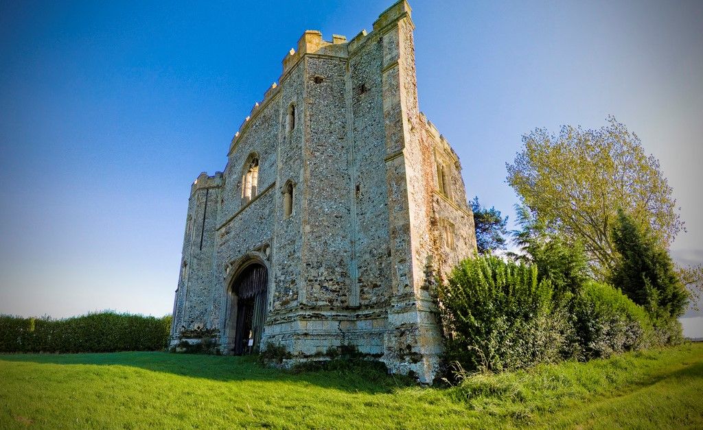
| Memorials | : | 6 |
| Location | : | Pentney, Kings Lynn and West Norfolk Borough, England |
| Coordinate | : | 52.6803890, 0.5143830 |
| Description | : | Also known as the Priory of the Holy Trinity, St Mary and St Magdalene An Augustinian Priory founded around 1130 by Robert De Vaux, a Norman nobles who came to England with William I the Conqueror. It was built on lands belonging to Hacon the Dane, Sir Robert installed Augustine Canons to pray for the souls of his family. The priory declined until it was consolidated with Wormegay Priory in 1468 and included in the Dissolution, sold to Thomas Manners, the Earl of Rutland in 1537. It is located a mile west of the village of Pentney on the north bank of... Read More |
frequently asked questions (FAQ):
-
Where is Pentney Priory?
Pentney Priory is located at Pentney, Kings Lynn and West Norfolk Borough ,Norfolk ,England.
-
Pentney Priory cemetery's updated grave count on graveviews.com?
6 memorials
-
Where are the coordinates of the Pentney Priory?
Latitude: 52.6803890
Longitude: 0.5143830
Nearby Cemetories:
1. Marham Cemetery
Marham, Kings Lynn and West Norfolk Borough, England
Coordinate: 52.6622260, 0.5287110
2. Holy Trinity Churchyard
Marham, Kings Lynn and West Norfolk Borough, England
Coordinate: 52.6583800, 0.5236900
3. St. Mary Magdalene Churchyard
Pentney, Kings Lynn and West Norfolk Borough, England
Coordinate: 52.6950490, 0.5449550
4. Shouldham Priory
Shouldham, Kings Lynn and West Norfolk Borough, England
Coordinate: 52.6576070, 0.4836220
5. Blackborough Priory
Middleton, Kings Lynn and West Norfolk Borough, England
Coordinate: 52.6989000, 0.4749000
6. St Cecilia's Churchyard
West Bilney, Kings Lynn and West Norfolk Borough, England
Coordinate: 52.7079810, 0.5395750
7. All Saints Churchyard
Shouldham, Kings Lynn and West Norfolk Borough, England
Coordinate: 52.6515690, 0.4837640
8. All Saints Churchyard
East Winch, Kings Lynn and West Norfolk Borough, England
Coordinate: 52.7175790, 0.5025340
9. All Saints Churchyard
Narborough, Breckland Borough, England
Coordinate: 52.6861790, 0.5825420
10. St. Botolph's Churchyard
Tottenhill, Kings Lynn and West Norfolk Borough, England
Coordinate: 52.6706000, 0.4433000
11. St Mary's Churchyard
Middleton, Kings Lynn and West Norfolk Borough, England
Coordinate: 52.7162502, 0.4595386
12. Saint Mary Churchyard
East Walton, Kings Lynn and West Norfolk Borough, England
Coordinate: 52.7146600, 0.5787130
13. St Martin's Churchyard
Fincham, Kings Lynn and West Norfolk Borough, England
Coordinate: 52.6296100, 0.4926900
14. St. Andrew's Churchyard
Barton Bendish, Kings Lynn and West Norfolk Borough, England
Coordinate: 52.6219270, 0.5277620
15. St. Mary's Churchyard
Narford, Breckland Borough, England
Coordinate: 52.6928740, 0.6095600
16. All Saints Churchyard
North Runcton, Kings Lynn and West Norfolk Borough, England
Coordinate: 52.7155370, 0.4360180
17. All Saints Churchyard
Ashwicken, Kings Lynn and West Norfolk Borough, England
Coordinate: 52.7404620, 0.5146680
18. St. Mary's Churchyard
Barton Bendish, Kings Lynn and West Norfolk Borough, England
Coordinate: 52.6198270, 0.5243860
19. St Nicholas Churchyard
Gayton, Kings Lynn and West Norfolk Borough, England
Coordinate: 52.7435700, 0.5615600
20. St. Mary's Churchyard
Gayton Thorpe, Kings Lynn and West Norfolk Borough, England
Coordinate: 52.7362310, 0.5832080
21. Saint Andrew's Churchyard
South Runcton, Kings Lynn and West Norfolk Borough, England
Coordinate: 52.6472700, 0.4128500
22. St. Mary's Churchyard
Stradsett, Kings Lynn and West Norfolk Borough, England
Coordinate: 52.6178500, 0.4588500
23. St Peter & St Paul's Church
Watlington, Kings Lynn and West Norfolk Borough, England
Coordinate: 52.6740960, 0.3961470
24. St. Mary the Virgin Churchyard
Beachamwell, Breckland Borough, England
Coordinate: 52.6178670, 0.5844730

