
| Memorials | : | 9 |
| Location | : | Persimmon Grove, Campbell County, USA |
| Coordinate | : | 38.9011500, -84.3444700 |
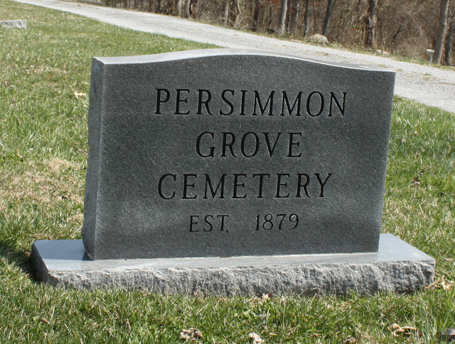
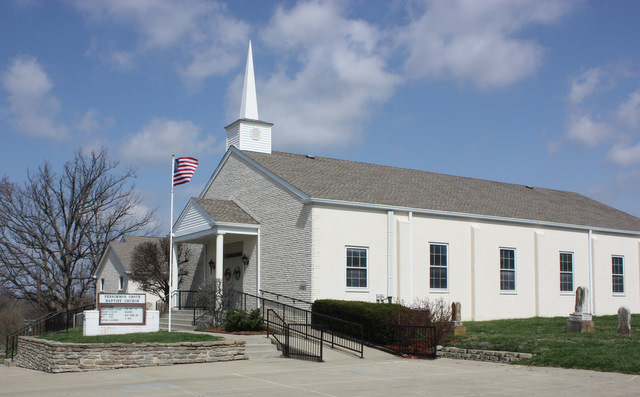
| Description | : | The cemetery is located at the intersection of Persimmons Grove Pike and Waggoner Road. The cemetery was established in 1879. The U.S. Geological Survey (USGS) Geographic Names Information System (GNIS) feature ID for the cemetery is 2089472 (Persimmon Grove Baptist Church Cemetery). |
frequently asked questions (FAQ):
-
Where is Persimmon Grove Cemetery?
Persimmon Grove Cemetery is located at 10471 Persimmon Grove Pike Persimmon Grove, Campbell County ,Kentucky ,USA.
-
Persimmon Grove Cemetery cemetery's updated grave count on graveviews.com?
7 memorials
-
Where are the coordinates of the Persimmon Grove Cemetery?
Latitude: 38.9011500
Longitude: -84.3444700
Nearby Cemetories:
1. Cherry Family Cemetery
Persimmon Grove, Campbell County, USA
Coordinate: 38.9101700, -84.3451110
2. Schoolfield Cemetery
Gubser Mill, Campbell County, USA
Coordinate: 38.8848110, -84.3389150
3. Herndon-Bartlow Family Cemetery
Carthage, Campbell County, USA
Coordinate: 38.9155556, -84.3305556
4. Caldwell Cemetery
Alexandria, Campbell County, USA
Coordinate: 38.8884730, -84.3668880
5. Saints Peter and Paul Church Cemetery
Gubser Mill, Campbell County, USA
Coordinate: 38.8769444, -84.3161100
6. Foster Byrd Family Cemetery
Aspen Grove, Campbell County, USA
Coordinate: 38.8906160, -84.3890430
7. Mount Gilead Methodist Evangelical Church Cemetery
Carthage, Campbell County, USA
Coordinate: 38.9342430, -84.3111630
8. Old Mount Gilead Cemetery
Carthage, Campbell County, USA
Coordinate: 38.9356030, -84.3099730
9. John Armstrong Tarvin Cemetery
Grants Lick, Campbell County, USA
Coordinate: 38.8596830, -84.3646170
10. John Byrd Cemetery
Aspen Grove, Campbell County, USA
Coordinate: 38.8916990, -84.4032690
11. Tarvin-Moore Cemetery
Carthage, Campbell County, USA
Coordinate: 38.9328070, -84.2974950
12. Kuhl Farm Cemetery
Claryville, Campbell County, USA
Coordinate: 38.9108330, -84.4064840
13. Corbin Family Cemetery
Carthage, Campbell County, USA
Coordinate: 38.9168500, -84.2828330
14. Ball Family Graveyard
California, Campbell County, USA
Coordinate: 38.9276670, -84.2864170
15. Rardin Cemetery
Carthage, Campbell County, USA
Coordinate: 38.9409500, -84.3002900
16. Harris Family Cemetery
California, Campbell County, USA
Coordinate: 38.8471790, -84.3596420
17. Richard Tarvin Cemetery
Grants Lick, Campbell County, USA
Coordinate: 38.8471070, -84.3594710
18. Stephens Farm Cemetery
Alexandria, Campbell County, USA
Coordinate: 38.9566350, -84.3528650
19. Pleasant Ridge Baptist Church Cemetery
Grants Lick, Campbell County, USA
Coordinate: 38.8949400, -84.4158200
20. Willard Neal Farm Cemetery
Alexandria, Campbell County, USA
Coordinate: 38.9571660, -84.3254490
21. Dunlap Grave
California, Campbell County, USA
Coordinate: 38.9223520, -84.2742330
22. Carmack Cemetery
Carthage, Campbell County, USA
Coordinate: 38.9582510, -84.3272630
23. James Lindsey Cemetery
California, Campbell County, USA
Coordinate: 38.9453680, -84.2926330
24. Oakland Cemetery
Grants Lick, Campbell County, USA
Coordinate: 38.8578600, -84.3997100