
| Memorials | : | 1 |
| Location | : | Crow Wing County, USA |
| Coordinate | : | 46.1713000, -94.2725000 |
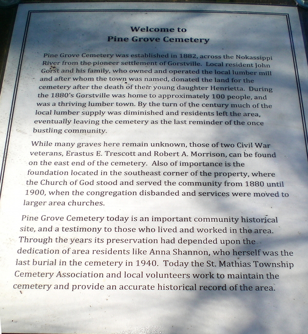
| Description | : | Pine Grove Cemetery is a small, rural cemetery in St. Mathias township used mainly by the original inhabitants of Gorstville, which no longer exists. The cemetery, now inactive, is maintained under an initiative of the township board to preserve the history of the township. It is at the western dead end of 10th street (a gravel road) in southern Crow Wing county. |
frequently asked questions (FAQ):
-
Where is Pine Grove Cemetery?
Pine Grove Cemetery is located at Crow Wing County ,Minnesota ,USA.
-
Pine Grove Cemetery cemetery's updated grave count on graveviews.com?
1 memorials
-
Where are the coordinates of the Pine Grove Cemetery?
Latitude: 46.1713000
Longitude: -94.2725000

Nearby Cemetories:
1. Saint Mathias Catholic Cemetery
Saint Mathias, Crow Wing County, USA
Coordinate: 46.2200000, -94.2517000
2. Dixon Cemetery
Fort Ripley, Crow Wing County, USA
Coordinate: 46.2154930, -94.3246630
3. Oak Hill Cemetery
Crow Wing County, USA
Coordinate: 46.2158012, -94.3285980
4. Fort Ripley Cemetery
Fort Ripley, Crow Wing County, USA
Coordinate: 46.1761000, -94.3615700
5. Riverside Cemetery
Crow Wing County, USA
Coordinate: 46.2224998, -94.1893997
6. Green Prairie Cemetery
Morrison County, USA
Coordinate: 46.1022400, -94.3527800
7. Oak Land Cemetery
Crow Wing County, USA
Coordinate: 46.2722015, -94.3043976
8. Minnesota State Veterans Cemetery
Little Falls, Morrison County, USA
Coordinate: 46.0752296, -94.3305206
9. Pine Tree Cemetery
Crow Wing County, USA
Coordinate: 46.2122000, -94.1214000
10. Saint Francis Assisi Cemetery
Brainerd, Crow Wing County, USA
Coordinate: 46.2752980, -94.3352060
11. Saint John Holy Cross Cemetery
Brainerd, Crow Wing County, USA
Coordinate: 46.2790970, -94.3328890
12. Freedhem Lutheran Cemetery
Freedhem, Morrison County, USA
Coordinate: 46.0612907, -94.2087021
13. Freedhem Free Evangelical Cemetery
Freedhem, Morrison County, USA
Coordinate: 46.0559500, -94.2069600
14. Fish Lake Cemetery
Darling, Morrison County, USA
Coordinate: 46.0637900, -94.3893300
15. Hamilton-Farrand Cemetery
Belle Prairie, Morrison County, USA
Coordinate: 46.0357050, -94.3374110
16. Hillside Cemetery
Long Lake Township, Crow Wing County, USA
Coordinate: 46.2577000, -94.1037000
17. Saint Marys Catholic Community Cemetery
Pierz, Morrison County, USA
Coordinate: 46.1093620, -94.0818390
18. Holy Family Church Cemetery
Belle Prairie, Morrison County, USA
Coordinate: 46.0325570, -94.3377920
19. Holy Cross Cemetery
Platte, Morrison County, USA
Coordinate: 46.1042000, -94.0813620
20. Holy Cross Church Cemetery
Pierz, Morrison County, USA
Coordinate: 46.1137400, -94.0408200
21. Roseland Cemetery
Randall, Morrison County, USA
Coordinate: 46.1286011, -94.5136032
22. Baxter Cemetery
Baxter, Crow Wing County, USA
Coordinate: 46.3455600, -94.2855600
23. Swedish Mission Church Cemetery
Morrison County, USA
Coordinate: 46.0283012, -94.4169006
24. Rail Prairie Union Cemetery
Morrison County, USA
Coordinate: 46.2519900, -94.4962200