
| Memorials | : | 4 |
| Location | : | Morrison County, USA |
| Coordinate | : | 46.2519900, -94.4962200 |
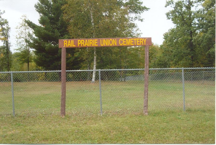
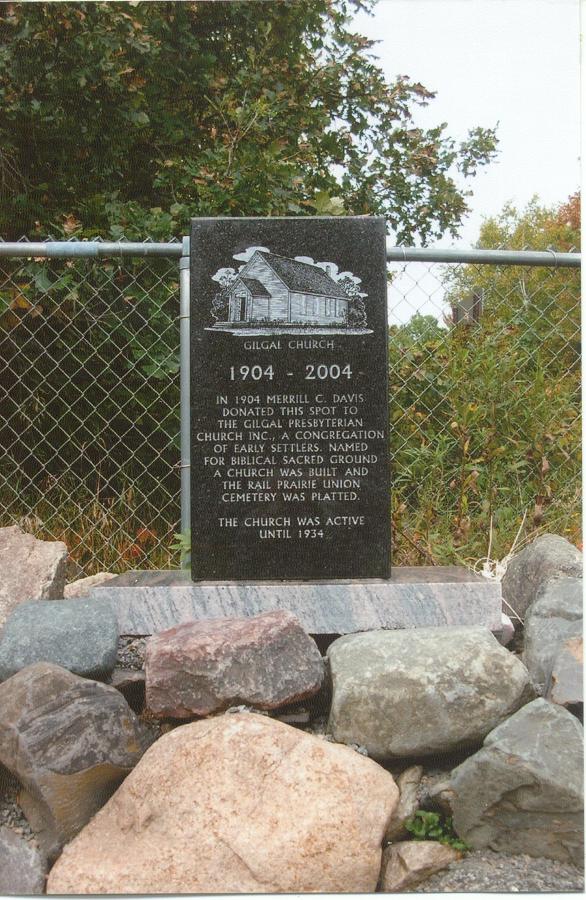
| Description | : | A Swedish Lutheran Church congregation was formed in Rail Prairie Township prior to 1900 but a dissident group broke away to form another church. The name adopted was the Gilgal Presbyterian Church in 1903. On May 12, 1903, 2.25 acres of property was deeded to the Trustees of the Gilgal Presbyterian Church. On December 22, 1904, a plat was recorded titled the "Rail Prairie Union Cemetery". Subsequently on July 30, 1905, a strip of land along the north side of the plat was marked as Church Yard. The property was 0.68 acres in size. The church was active until June... Read More |
frequently asked questions (FAQ):
-
Where is Rail Prairie Union Cemetery?
Rail Prairie Union Cemetery is located at Scandia Valley Towns Morrison County ,Minnesota ,USA.
-
Rail Prairie Union Cemetery cemetery's updated grave count on graveviews.com?
0 memorials
-
Where are the coordinates of the Rail Prairie Union Cemetery?
Latitude: 46.2519900
Longitude: -94.4962200
Nearby Cemetories:
1. Lutheran Cemetery
Morrison County, USA
Coordinate: 46.2378490, -94.5171960
2. Ogema Point Cemetery
Cushing, Morrison County, USA
Coordinate: 46.2146988, -94.5393982
3. Scandia Valley Cemetery West
Cushing, Morrison County, USA
Coordinate: 46.2138890, -94.5400000
4. Pillager Frontier Cemetery
Pillager, Cass County, USA
Coordinate: 46.3171997, -94.4944000
5. Franzen Family Cemetery
Little Falls, Morrison County, USA
Coordinate: 46.3158970, -94.4431250
6. Wildwood Cemetery
Pillager, Cass County, USA
Coordinate: 46.3311005, -94.4627991
7. Sylvan Cemetery
Sylvan, Cass County, USA
Coordinate: 46.3333300, -94.4113900
8. Saint Francis Assisi Cemetery
Brainerd, Crow Wing County, USA
Coordinate: 46.2752980, -94.3352060
9. Saint John Holy Cross Cemetery
Brainerd, Crow Wing County, USA
Coordinate: 46.2790970, -94.3328890
10. Fort Ripley Cemetery
Fort Ripley, Crow Wing County, USA
Coordinate: 46.1761000, -94.3615700
11. Oak Hill Cemetery
Crow Wing County, USA
Coordinate: 46.2158012, -94.3285980
12. Gull River Cemetery
Cass County, USA
Coordinate: 46.3356018, -94.3685989
13. Cushing Union Cemetery
Cushing, Morrison County, USA
Coordinate: 46.1409580, -94.5755700
14. Roseland Cemetery
Randall, Morrison County, USA
Coordinate: 46.1286011, -94.5136032
15. Dixon Cemetery
Fort Ripley, Crow Wing County, USA
Coordinate: 46.2154930, -94.3246630
16. Motley Public Cemetery
Todd County, USA
Coordinate: 46.3278008, -94.6556015
17. Oak Land Cemetery
Crow Wing County, USA
Coordinate: 46.2722015, -94.3043976
18. Bridgeman Cemetery
Cass County, USA
Coordinate: 46.3796997, -94.5689011
19. Saint James Cemetery
Fawn Lake Township, Todd County, USA
Coordinate: 46.2799988, -94.7181015
20. Saint Thomas of the Pines Cemetery
East Gull Lake, Cass County, USA
Coordinate: 46.3921300, -94.3809900
21. Randall Cemetery
Randall, Morrison County, USA
Coordinate: 46.0910988, -94.5143967
22. Oak Hill Cemetery
Randall, Morrison County, USA
Coordinate: 46.0855290, -94.5185410
23. Saint James Catholic Cemetery
Randall, Morrison County, USA
Coordinate: 46.0830994, -94.4933014
24. Saint Mathias Catholic Cemetery
Saint Mathias, Crow Wing County, USA
Coordinate: 46.2200000, -94.2517000