
| Memorials | : | 4 |
| Location | : | Barnard, Nodaway County, USA |
| Coordinate | : | 40.1413994, -94.7692032 |
frequently asked questions (FAQ):
-
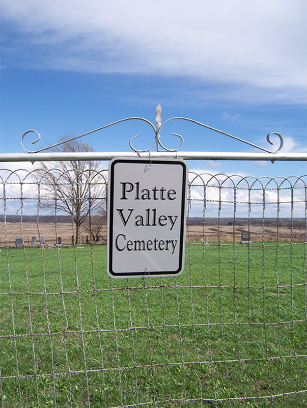
Where is Platte Valley Cemetery?
Platte Valley Cemetery is located at Barnard, Nodaway County ,Missouri ,USA.
-
Platte Valley Cemetery cemetery's updated grave count on graveviews.com?
4 memorials
-
Where are the coordinates of the Platte Valley Cemetery?
Latitude: 40.1413994
Longitude: -94.7692032
Nearby Cemetories:
1. Jackson Cemetery
Barnard, Nodaway County, USA
Coordinate: 40.1561012, -94.7842026
2. Upper Neely Grove Cemetery
Bolckow, Andrew County, USA
Coordinate: 40.1083488, -94.7961807
3. Groves Cemetery
Guilford, Nodaway County, USA
Coordinate: 40.1567001, -94.7221985
4. Weathermon Cemetery
Guilford, Nodaway County, USA
Coordinate: 40.1683998, -94.7240829
5. Bolckow Cemetery
Bolckow, Andrew County, USA
Coordinate: 40.1131210, -94.8142929
6. Graves Cemetery
Guilford, Nodaway County, USA
Coordinate: 40.1730995, -94.7276764
7. Walnut Grove Methodist Cemetery
Andrew County, USA
Coordinate: 40.0967598, -94.7518311
8. Barnard American Legion Cemetery
Barnard, Nodaway County, USA
Coordinate: 40.1839600, -94.8173828
9. Barnard Masonic-IOOF Cemetery
Barnard, Nodaway County, USA
Coordinate: 40.1845818, -94.8176727
10. Alumbaugh Cemetery
Barnard, Nodaway County, USA
Coordinate: 40.1843987, -94.8383026
11. Baker Cemetery
Barnard, Nodaway County, USA
Coordinate: 40.1660800, -94.8636600
12. Sharp Cemetery
Barnard, Nodaway County, USA
Coordinate: 40.2176190, -94.7630450
13. Litts Cemetery
Whitecloud, Nodaway County, USA
Coordinate: 40.1377983, -94.8756027
14. Lower Neely Grove Cemetery
Andrew County, USA
Coordinate: 40.0627594, -94.8138733
15. Whitesville Cemetery
Whitesville, Andrew County, USA
Coordinate: 40.0626183, -94.7162094
16. McBrien Cemetery
Rosendale, Andrew County, USA
Coordinate: 40.0698900, -94.8589600
17. Salem Cemetery
Pumpkin Center, Nodaway County, USA
Coordinate: 40.2076721, -94.8683167
18. Clemmens Cemetery
Whitesville, Andrew County, USA
Coordinate: 40.0401430, -94.7413400
19. Star Chapel United Methodist Cemetery
Empire Prairie, Andrew County, USA
Coordinate: 40.0828094, -94.6399231
20. Swinford Cemetery
Barnard, Nodaway County, USA
Coordinate: 40.2570190, -94.7569427
21. Saint Columba Cemetery
Conception, Nodaway County, USA
Coordinate: 40.2431107, -94.6842957
22. Lafayette Cemetery
Guilford, Nodaway County, USA
Coordinate: 40.1478806, -94.6112366
23. Pleasant Grove Cemetery
Pumpkin Center, Nodaway County, USA
Coordinate: 40.2188110, -94.8918610
24. Mize II Cemetery
Jacksonville, Gentry County, USA
Coordinate: 40.1040700, -94.6061200