| Memorials | : | 6 |
| Location | : | Clearview, Carleton County, Canada |
| Coordinate | : | 46.5637693, -67.7153083 |
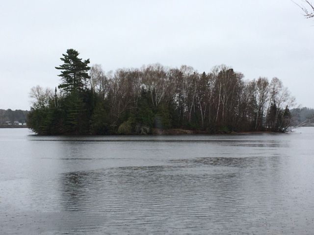
| Description | : | The Pomphrey Island Cemetery is one of the oldest known burial grounds in Carleton County. The earliest burial in the cemetery is that of Helkiah Kearny of River de Chute who died January 16th, 1833. The burial ground is located on grant lot 30 in the Military Settlement which was granted to Private Thomas Pomphrey of the 104th Regiment of Foot and for whom it is named after. When Thomas Pomphrey died in December of 1871 he left the cemetery to the Baptist congregation. In his will dated June 4th, 1861 and probated on July 24, 1862 he... Read More |
frequently asked questions (FAQ):
-
Where is Pomphrey Island Cemetery?
Pomphrey Island Cemetery is located at Clearview, Carleton County ,New Brunswick ,Canada.
-
Pomphrey Island Cemetery cemetery's updated grave count on graveviews.com?
6 memorials
-
Where are the coordinates of the Pomphrey Island Cemetery?
Latitude: 46.5637693
Longitude: -67.7153083
Nearby Cemetories:
1. St Bartholomew Catholic Cemetery
Clearview, Carleton County, Canada
Coordinate: 46.5730900, -67.7196300
2. Wharton Cemetery
Upper Kent, Carleton County, Canada
Coordinate: 46.5583300, -67.7011100
3. Hawthorne Cemetery
Upper Kent, Carleton County, Canada
Coordinate: 46.5833177, -67.7179017
4. Pomphrey Cemetery
Wicklow, Carleton County, Canada
Coordinate: 46.5437840, -67.6802360
5. River de Chute Cemetery
Carleton County, Canada
Coordinate: 46.5935500, -67.7500700
6. Summerfield Cemetery
Wicklow, Carleton County, Canada
Coordinate: 46.5249990, -67.7083540
7. Beechwood United Baptist Cemetery
Beechwood, Carleton County, Canada
Coordinate: 46.5433300, -67.6625000
8. Upper Knoxford Cemetery
Upper Knoxford, Carleton County, Canada
Coordinate: 46.5205700, -67.7492700
9. Moose Mountain Pioneer Cemetery
Moose Mountain, Carleton County, Canada
Coordinate: 46.6007340, -67.6610030
10. Taylor Cemetery
Piercemont, Carleton County, Canada
Coordinate: 46.5548580, -67.6317020
11. Bairdsville Anglican Cemetery
Bairdsville, Victoria County, Canada
Coordinate: 46.6269606, -67.7164698
12. Buckley Cemetery
Holmesville, Carleton County, Canada
Coordinate: 46.5781683, -67.6194186
13. Currie Cemetery
Bath, Carleton County, Canada
Coordinate: 46.5293370, -67.6286000
14. Lower Knoxford Cemetery
Knoxford, Carleton County, Canada
Coordinate: 46.4906400, -67.7368900
15. Greenfield Anglican Cemetery
Greenfield, Carleton County, Canada
Coordinate: 46.4900710, -67.6862390
16. Kilburn Community Cemetery
Kilburn, Victoria County, Canada
Coordinate: 46.6406400, -67.7061800
17. Free Will Baptist Church Cemetery
Holmesville, Carleton County, Canada
Coordinate: 46.5748720, -67.6033510
18. Gee Flat Cemetery
Bath, Carleton County, Canada
Coordinate: 46.5213340, -67.6162040
19. Melville Cemetery
Kincardine, Victoria County, Canada
Coordinate: 46.6366790, -67.6660930
20. Pine Tree Cemetery
Bath, Carleton County, Canada
Coordinate: 46.5164370, -67.6046100
21. Royalton Cemetery
Wicklow, Carleton County, Canada
Coordinate: 46.4820030, -67.7707210
22. Mineral Cemetery
Kent, Carleton County, Canada
Coordinate: 46.5918753, -67.5843827
23. East Blaine Cemetery
Blaine, Aroostook County, USA
Coordinate: 46.4953800, -67.8143500
24. Barker Cemetery
Bath, Carleton County, Canada
Coordinate: 46.5102780, -67.5961110

