
| Memorials | : | 0 |
| Location | : | Haschbach am Remigiusberg, Landkreis Kusel, Germany |
| Coordinate | : | 49.5212180, 7.4382500 |
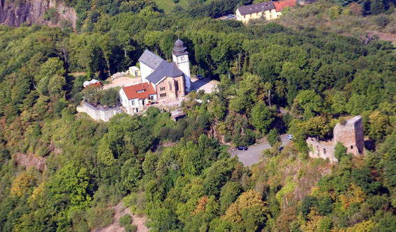
| Description | : | An existing and modern Remigius Church is what is left over, here in southwestern Germany, from a once impressive cloister complex of Benedictine monks, the Abbey of St. Remigius, Remigiusberg. Its foundation can be attributed to the donation in the 6th century of a parcel of land of about 220 square kilometers, later called Remigiusland, to the Bishopric of Reims by Frankish King Childebert II. Administrative problems the French Archbishop had because of his distance from this property finally led an 11th century prelate to turn it over to more local church authorities. A document of the Archbishop of Mainz,... Read More |
frequently asked questions (FAQ):
-
Where is Propsteikirche?
Propsteikirche is located at Haschbach am Remigiusberg, Landkreis Kusel ,Rheinland-Pfalz ,Germany.
-
Propsteikirche cemetery's updated grave count on graveviews.com?
0 memorials
-
Where are the coordinates of the Propsteikirche?
Latitude: 49.5212180
Longitude: 7.4382500
Nearby Cemetories:
1. Friedhof Rutsweiler am Glan
Rutsweiler am Glan, Landkreis Kusel, Germany
Coordinate: 49.5316860, 7.4578340
2. Friedhof Kusel
Kirrweiler, Landkreis Kusel, Germany
Coordinate: 49.5416190, 7.4167560
3. Friedhof Altenglan
Altenglan, Landkreis Kusel, Germany
Coordinate: 49.5542360, 7.4599070
4. Friedhof Rehweiler
Rehweiler, Landkreis Kusel, Germany
Coordinate: 49.4803625, 7.4387971
5. Friedhof Quirnbach
Quirnbach, Landkreis Kusel, Germany
Coordinate: 49.4784922, 7.4182498
6. Friedhof Henschtal
Landkreis Kusel, Germany
Coordinate: 49.4646293, 7.4056378
7. Trahweiler
Trahweiler, Landkreis Kusel, Germany
Coordinate: 49.4643049, 7.4015576
8. Jüdischer Friedhof Steinbach am Glan
Steinbach, Landkreis Kusel, Germany
Coordinate: 49.4577760, 7.3982190
9. Ulmet Flurskapelle
Ulmet, Landkreis Kusel, Germany
Coordinate: 49.5912230, 7.4527580
10. Friedhof Pfeffelbach
Pfeffelbach, Landkreis Kusel, Germany
Coordinate: 49.5417772, 7.3308117
11. Friedhof 2
Frutzweiler, Landkreis Kusel, Germany
Coordinate: 49.4546832, 7.3807754
12. Friedhof 1
Frutzweiler, Landkreis Kusel, Germany
Coordinate: 49.4517685, 7.3762781
13. Friedhof Ohmbach
Ohmbach, Landkreis Kusel, Germany
Coordinate: 49.4509570, 7.3474230
14. Friedhof Ramstein
Ramstein-Miesenbach, Landkreis Kaiserslautern, Germany
Coordinate: 49.4473300, 7.5494100
15. Friedhof Fohren-Linden
Fohren-Linden, Landkreis Birkenfeld, Germany
Coordinate: 49.5890821, 7.2836588
16. Friedhof Kübelberg
Schönenberg-Kübelberg, Landkreis Kusel, Germany
Coordinate: 49.4079629, 7.3698712
17. Friedhof Hauptstuhl
Hauptstuhl, Landkreis Kaiserslautern, Germany
Coordinate: 49.4003883, 7.4991166
18. Ilgesheim Evangelical Cemetery
Ilgesheim, Landkreis Kusel, Germany
Coordinate: 49.6510000, 7.4454300
19. Friedhofsverwaltung
Bad Kreuznach, Landkreis Bad Kreuznach, Germany
Coordinate: 49.4000000, 7.5200000
20. St. Andreas-Kirche
Landstuhl, Landkreis Kaiserslautern, Germany
Coordinate: 49.4095100, 7.5701620
21. Landstuhl Cemetery
Landstuhl, Landkreis Kaiserslautern, Germany
Coordinate: 49.4132313, 7.5803565
22. Hausweiler Friedhof
Hausweiler, Landkreis Kusel, Germany
Coordinate: 49.6460360, 7.5604180
23. Friedhof Kindsbach
Kindsbach, Landkreis Kaiserslautern, Germany
Coordinate: 49.4167321, 7.6071109
24. Friedhof Martinshöhe
Martinshöhe, Landkreis Kaiserslautern, Germany
Coordinate: 49.3700529, 7.4817782