
| Memorials | : | 0 |
| Location | : | Ulmet, Landkreis Kusel, Germany |
| Coordinate | : | 49.5912230, 7.4527580 |
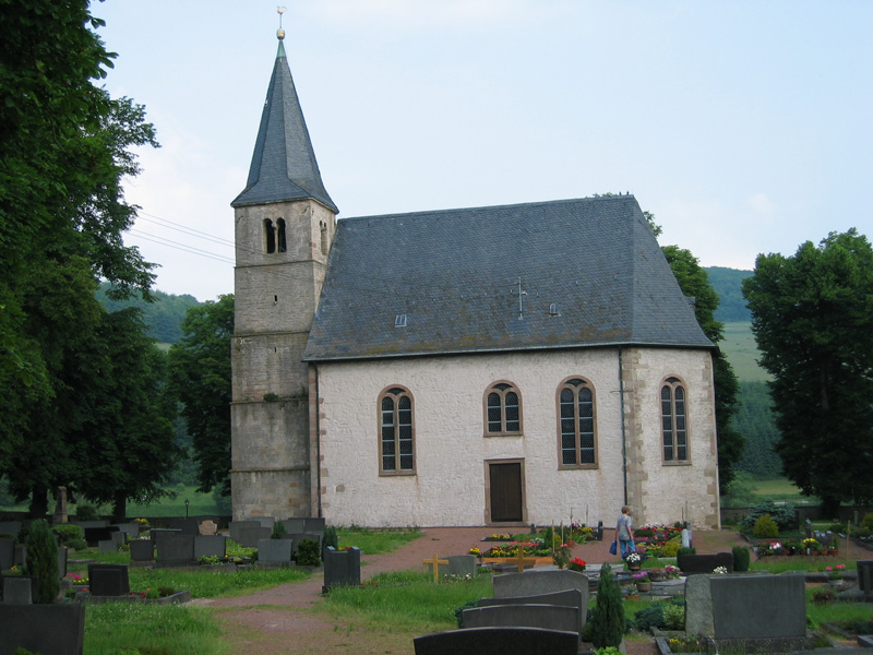
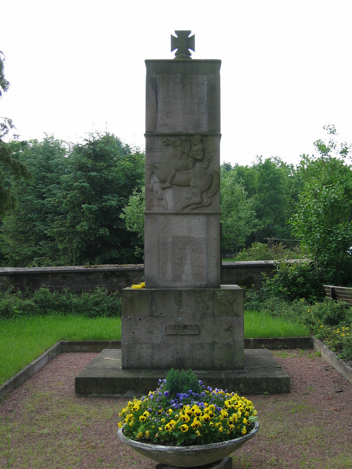
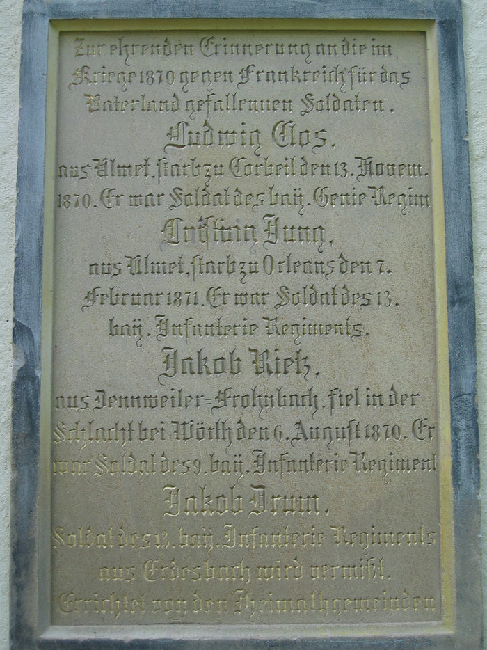
| Description | : | The parish church of Ulmet is one of the oldest churches in the middle Glan River Valley region. For centuries it has been known as the Flurskapelle (popularly translated as "chapel in the fields")*, serving the Reformed population in the settlements and small villages around it. The church is located on the edge of the village of Ulmet in the Kreis (District) of Kusel in the Rheinland-Pfalz (Rhineland-Palatinate) of southwestern Germany. The church and its churchyard are about 1 km. away, across the Kapeller Brücke ("Chapel Bridge" over the Glan River) from the village of Rathsweiler, which can be seen... Read More |
frequently asked questions (FAQ):
-
Where is Ulmet Flurskapelle?
Ulmet Flurskapelle is located at Ulmet, Landkreis Kusel ,Rheinland-Pfalz ,Germany.
-
Ulmet Flurskapelle cemetery's updated grave count on graveviews.com?
0 memorials
-
Where are the coordinates of the Ulmet Flurskapelle?
Latitude: 49.5912230
Longitude: 7.4527580
Nearby Cemetories:
1. Friedhof Altenglan
Altenglan, Landkreis Kusel, Germany
Coordinate: 49.5542360, 7.4599070
2. Friedhof Kusel
Kirrweiler, Landkreis Kusel, Germany
Coordinate: 49.5416190, 7.4167560
3. Friedhof Rutsweiler am Glan
Rutsweiler am Glan, Landkreis Kusel, Germany
Coordinate: 49.5316860, 7.4578340
4. Ilgesheim Evangelical Cemetery
Ilgesheim, Landkreis Kusel, Germany
Coordinate: 49.6510000, 7.4454300
5. Propsteikirche
Haschbach am Remigiusberg, Landkreis Kusel, Germany
Coordinate: 49.5212180, 7.4382500
6. Hausweiler Friedhof
Hausweiler, Landkreis Kusel, Germany
Coordinate: 49.6460360, 7.5604180
7. Friedhof Pfeffelbach
Pfeffelbach, Landkreis Kusel, Germany
Coordinate: 49.5417772, 7.3308117
8. Friedhof Fohren-Linden
Fohren-Linden, Landkreis Birkenfeld, Germany
Coordinate: 49.5890821, 7.2836588
9. Friedhof Rehweiler
Rehweiler, Landkreis Kusel, Germany
Coordinate: 49.4803625, 7.4387971
10. Friedhof Quirnbach
Quirnbach, Landkreis Kusel, Germany
Coordinate: 49.4784922, 7.4182498
11. Friedhof Henschtal
Landkreis Kusel, Germany
Coordinate: 49.4646293, 7.4056378
12. Trahweiler
Trahweiler, Landkreis Kusel, Germany
Coordinate: 49.4643049, 7.4015576
13. Friedhof Otzweiler
Otzweiler, Landkreis Bad Kreuznach, Germany
Coordinate: 49.7166700, 7.5166700
14. Jüdischer Friedhof Steinbach am Glan
Steinbach, Landkreis Kusel, Germany
Coordinate: 49.4577760, 7.3982190
15. Friedhof Weierbach
Weierbach, Landkreis Birkenfeld, Germany
Coordinate: 49.7251586, 7.3950531
16. Friedhof 2
Frutzweiler, Landkreis Kusel, Germany
Coordinate: 49.4546832, 7.3807754
17. Adenbach alter Friedhof
Adenbach, Landkreis Kusel, Germany
Coordinate: 49.6684940, 7.6463450
18. Friedhof 1
Frutzweiler, Landkreis Kusel, Germany
Coordinate: 49.4517685, 7.3762781
19. Adenbach Friedhof
Adenbach, Landkreis Kusel, Germany
Coordinate: 49.6657590, 7.6513760
20. Friedhof Ohmbach
Ohmbach, Landkreis Kusel, Germany
Coordinate: 49.4509570, 7.3474230
21. Friedhof Ramstein
Ramstein-Miesenbach, Landkreis Kaiserslautern, Germany
Coordinate: 49.4473300, 7.5494100
22. Friedhof Rudolphskirchen
Rathskirchen, Donnersbergkreis, Germany
Coordinate: 49.6198043, 7.7095683
23. Schlosskirche Meisenheim
Meisenheim, Landkreis Bad Kreuznach, Germany
Coordinate: 49.7051800, 7.6718080
24. Evangelical Church Cemetery
Kirschroth, Landkreis Bad Kreuznach, Germany
Coordinate: 49.7613200, 7.5688700