
| Memorials | : | 0 |
| Location | : | Burlington, Racine County, USA |
| Phone | : | 262-763-7482 |
| Website | : | www.stjohnthedivine.org/columbarium-ministry.html |
| Coordinate | : | 42.6750700, -88.2750200 |
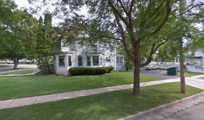
| Description | : | Saint John the Divine Episcopal Church Columbarium is located in the bell tower of Saint John the Divine Episcopal Church. |
frequently asked questions (FAQ):
-
Where is Saint John the Divine Episcopal Church Columbarium?
Saint John the Divine Episcopal Church Columbarium is located at 216 East Chandler Boulevard Burlington, Racine County ,Wisconsin , 53105USA.
-
Saint John the Divine Episcopal Church Columbarium cemetery's updated grave count on graveviews.com?
0 memorials
-
Where are the coordinates of the Saint John the Divine Episcopal Church Columbarium?
Latitude: 42.6750700
Longitude: -88.2750200
Nearby Cemetories:
1. Gods Acre Cemetery
Burlington, Racine County, USA
Coordinate: 42.6741982, -88.2853012
2. Burlington Cemetery
Burlington, Racine County, USA
Coordinate: 42.6831017, -88.2585983
3. Saint Charles Cemetery
Burlington, Racine County, USA
Coordinate: 42.6739006, -88.3000031
4. Old Burlington Cemetery
Burlington, Racine County, USA
Coordinate: 42.6843500, -88.2522500
5. Old Voree Cemetery
Spring Prairie, Walworth County, USA
Coordinate: 42.6767100, -88.3062000
6. Rooker Cemetery
Burlington, Racine County, USA
Coordinate: 42.6974983, -88.2925034
7. Frank Williams Cemetery
Spring Prairie, Walworth County, USA
Coordinate: 42.7048600, -88.3218000
8. Diener Cemetery
Spring Prairie, Walworth County, USA
Coordinate: 42.7049490, -88.3219990
9. Mount Hope Cemetery
Spring Prairie, Walworth County, USA
Coordinate: 42.7006400, -88.3356900
10. Karcher Cemetery
Burlington, Racine County, USA
Coordinate: 42.6215800, -88.2535400
11. Hudson Cemetery
Lyons, Walworth County, USA
Coordinate: 42.6577988, -88.3585968
12. High Street Cemetery
Wheatland, Kenosha County, USA
Coordinate: 42.6067009, -88.2668991
13. Lyons Quaker Cemetery
Lyons, Walworth County, USA
Coordinate: 42.6402300, -88.3577500
14. West Meadows Cemetery
Rochester, Racine County, USA
Coordinate: 42.7203760, -88.2021470
15. Eagle Creek Religious Society Cemetery
Burlington, Racine County, USA
Coordinate: 42.7143500, -88.1936900
16. Rochester Cemetery
Rochester, Racine County, USA
Coordinate: 42.7444900, -88.2386800
17. Honey Creek Cemetery
Rochester, Racine County, USA
Coordinate: 42.7478300, -88.3059200
18. Saint Josephs Catholic Cemetery
Lyons, Walworth County, USA
Coordinate: 42.6371994, -88.3668976
19. Honey Creek Memorial Cemetery
Rochester, Racine County, USA
Coordinate: 42.7494800, -88.3073400
20. Rosewood Cemetery
Rosewood, Racine County, USA
Coordinate: 42.6840800, -88.1650300
21. German Settlement Cemetery
Spring Prairie, Walworth County, USA
Coordinate: 42.7413800, -88.3622200
22. Saint Johns Evangelical Lutheran Cemetery
Slades Corners, Kenosha County, USA
Coordinate: 42.5824780, -88.2837510
23. Saint Thomas Aquinas Cemetery
Waterford, Racine County, USA
Coordinate: 42.7564300, -88.2101400
24. Free Will Baptist Cemetery
Wheatland, Kenosha County, USA
Coordinate: 42.5791670, -88.2619440