
| Memorials | : | 849 |
| Location | : | Freedom Township, Henry County, USA |
| Coordinate | : | 41.4491997, -84.1727982 |
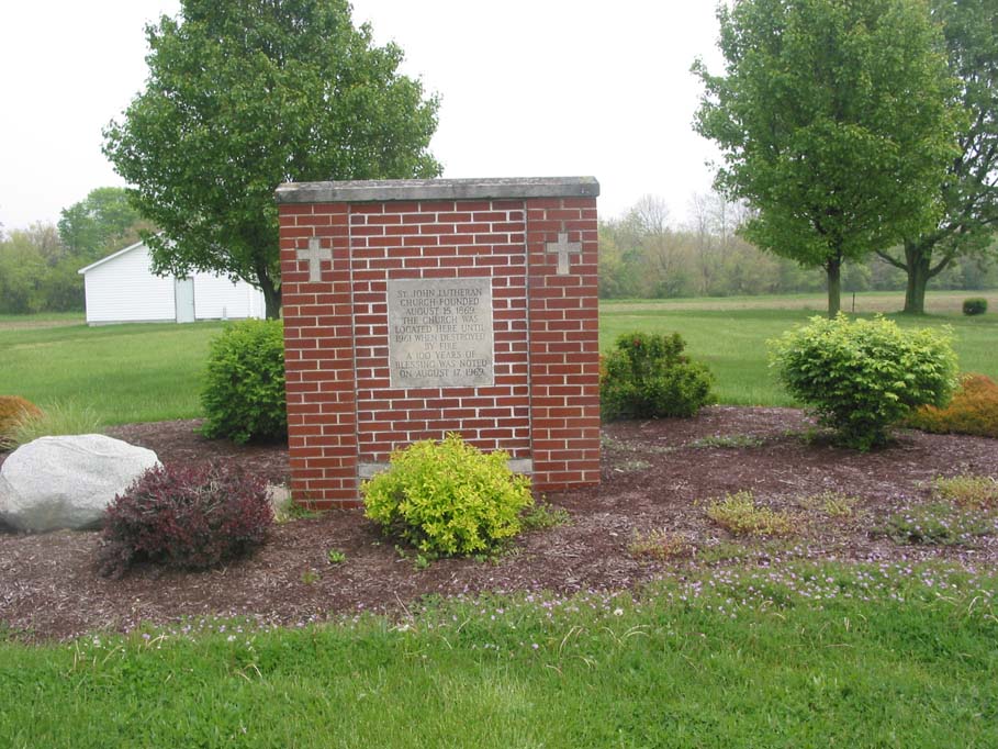
| Description | : | The cemetery is located on the east side of County Road 16 about 0.5 miles north of its intersection with County Road U. The cemetery is located in Freedom Township, Henry County, Ohio, and is # 5076 (Saint Johns Lutheran Cemetery / Saint Johns Cemetery) in “Ohio Cemeteries 1803-2003”, compiled by the Ohio Genealogical Society. The U.S. Geological Survey (USGS) Geographic Names Information System (GNIS) feature ID for the cemetery is 1050145 (Saint Johns Cemetery / Saint John’s Lutheran Cemetery). |
frequently asked questions (FAQ):
-
Where is Saint Johns Cemetery?
Saint Johns Cemetery is located at County Road 16 Freedom Township, Henry County ,Ohio , 43545USA.
-
Saint Johns Cemetery cemetery's updated grave count on graveviews.com?
847 memorials
-
Where are the coordinates of the Saint Johns Cemetery?
Latitude: 41.4491997
Longitude: -84.1727982

Nearby Cemetories:
1. Henry County Home Cemetery
Henry County, USA
Coordinate: 41.4212830, -84.1506900
2. Union Chapel Cemetery
Napoleon, Henry County, USA
Coordinate: 41.4166985, -84.1877975
3. Freedom Township Cemetery
Freedom Township, Henry County, USA
Coordinate: 41.4752970, -84.2069960
4. Saint Pauls Lutheran Cemetery
Napoleon, Henry County, USA
Coordinate: 41.4061060, -84.1900350
5. Saint Pauls Cemetery
Napoleon, Henry County, USA
Coordinate: 41.4063290, -84.2163380
6. Saint Lukes Lutheran Church Cemetery
Fulton County, USA
Coordinate: 41.4963100, -84.1340700
7. Zion Lutheran Church Cemetery
Napoleon, Henry County, USA
Coordinate: 41.4414170, -84.2495930
8. Saint Peter Lutheran Cemetery
Ridgeville Township, Henry County, USA
Coordinate: 41.4389000, -84.2549973
9. Locust Grove Cemetery
Ridgeville Corners, Henry County, USA
Coordinate: 41.4389650, -84.2558060
10. Lena Cemetery
Fulton County, USA
Coordinate: 41.5175018, -84.1731033
11. Bremer Cemetery
Okolona, Henry County, USA
Coordinate: 41.3863980, -84.2093960
12. Glenwood Cemetery
Napoleon, Henry County, USA
Coordinate: 41.3838997, -84.1425018
13. Aeschliman Cemetery
Pettisville, Fulton County, USA
Coordinate: 41.5147018, -84.2192001
14. Forest Hill Cemetery
Napoleon, Henry County, USA
Coordinate: 41.3913994, -84.1100006
15. Bethlehem Lutheran Cemetery
Defiance County, USA
Coordinate: 41.4050120, -84.2608930
16. West Barre Cemetery
Fulton County, USA
Coordinate: 41.5168970, -84.1122450
17. Saint Augustine Cemetery
Napoleon, Henry County, USA
Coordinate: 41.3767014, -84.1172028
18. Pettisville Union Cemetery
Pettisville, Fulton County, USA
Coordinate: 41.5294190, -84.2258910
19. Bethlehem Lutheran Cemetery
Defiance County, USA
Coordinate: 41.3702100, -84.2291200
20. Pettisville Cemetery
Pettisville, Fulton County, USA
Coordinate: 41.5302620, -84.2258690
21. Morrison Cemetery
Liberty Center, Henry County, USA
Coordinate: 41.4426420, -84.0525720
22. Pettisville Lutheran Cemetery
Pettisville, Fulton County, USA
Coordinate: 41.5321900, -84.2237400
23. Liberty Chapel Cemetery
Liberty Center, Henry County, USA
Coordinate: 41.4719962, -84.0477244
24. Brey Cemetery
Napoleon, Henry County, USA
Coordinate: 41.3534610, -84.1991170