
| Memorials | : | 88 |
| Location | : | Lancaster, Fairfield County, USA |
| Coordinate | : | 39.7461014, -82.5017014 |
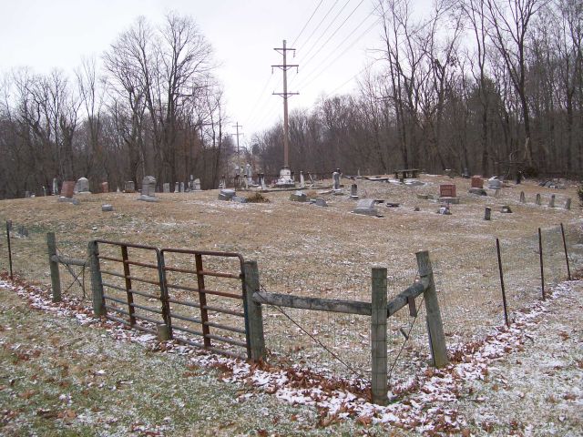
| Description | : | The cemetery is approximately a half acre in size. It is located about 4/10's of a mile north of State Route 22 (aka Cincinnati - Zanesville Road) on the east side of Lake Road NE (County Road 60) just north of the Lake Road NE and Wheeling Road intersection. The cemetery is located in Pleasant Township, Fairfield County, Ohio, and # 3224 (Colfax Cemetery / Saint Matthews Cemetery) in “Ohio Cemeteries 1803-2003”, compiled by the Ohio Genealogical Society. |
frequently asked questions (FAQ):
-
Where is Saint Mathews Cemetery?
Saint Mathews Cemetery is located at 1720 Lake Road NE (County Road 60) Lancaster, Fairfield County ,Ohio , 43130USA.
-
Saint Mathews Cemetery cemetery's updated grave count on graveviews.com?
88 memorials
-
Where are the coordinates of the Saint Mathews Cemetery?
Latitude: 39.7461014
Longitude: -82.5017014
Nearby Cemetories:
1. Grace Evangelical Lutheran Church Cemetery
Lancaster, Fairfield County, USA
Coordinate: 39.7491330, -82.4894720
2. Tent Church Cemetery
Lancaster, Fairfield County, USA
Coordinate: 39.7485929, -82.4819305
3. Pleasant Hill United Methodist Cemetery
Pleasant Township, Fairfield County, USA
Coordinate: 39.7454830, -82.5303940
4. Maple Grove Cemetery
Lancaster, Fairfield County, USA
Coordinate: 39.7266998, -82.5186005
5. Amish Mennonite Cemetery
Lancaster, Fairfield County, USA
Coordinate: 39.7218610, -82.5035470
6. Bibler Cemetery
Fairfield County, USA
Coordinate: 39.7214012, -82.5081024
7. Casper Hufford Cemetery
Lancaster, Fairfield County, USA
Coordinate: 39.7196198, -82.4976425
8. Baptist Corners Cemetery
Lancaster, Fairfield County, USA
Coordinate: 39.7732520, -82.5059350
9. Friesner Cemetery
Lancaster, Fairfield County, USA
Coordinate: 39.7252998, -82.5258026
10. Mount Tabor Cemetery
Fairfield County, USA
Coordinate: 39.7205000, -82.5174330
11. Friend-Ruffner Cemetery
West Rushville, Fairfield County, USA
Coordinate: 39.7714005, -82.4728012
12. Emanuel Lutheran Church Cemetery
Lancaster, Fairfield County, USA
Coordinate: 39.7497128, -82.5490379
13. Collins Chapel Cemetery
Fairfield County, USA
Coordinate: 39.7097015, -82.4961014
14. Keller Cemetery
Fairfield County, USA
Coordinate: 39.7728060, -82.5377860
15. Driver Cemetery
Bremen, Fairfield County, USA
Coordinate: 39.7144012, -82.4721985
16. Applegate Cemetery
Lancaster, Fairfield County, USA
Coordinate: 39.7202988, -82.5421982
17. Winters Cemetery
Pleasantville, Fairfield County, USA
Coordinate: 39.7812260, -82.5382020
18. Mount Zion Cemetery
Bremen, Fairfield County, USA
Coordinate: 39.7075005, -82.4666977
19. Huber Cemetery
Lancaster, Fairfield County, USA
Coordinate: 39.7407220, -82.5626840
20. Asbury Cemetery
Lancaster, Fairfield County, USA
Coordinate: 39.7221985, -82.5558014
21. West Rushville Cemetery
West Rushville, Fairfield County, USA
Coordinate: 39.7644005, -82.4424973
22. Teel Cemetery
Pleasantville, Fairfield County, USA
Coordinate: 39.7961390, -82.4937630
23. Stevenson Ruffner Cemetery
Richland Township, Fairfield County, USA
Coordinate: 39.7863998, -82.4582977
24. Sites-Sitz-Greenfiled-Ewing Cemetery
Lancaster, Fairfield County, USA
Coordinate: 39.7478828, -82.5699997