
| Memorials | : | 64 |
| Location | : | Lancaster, Fairfield County, USA |
| Coordinate | : | 39.7485929, -82.4819305 |
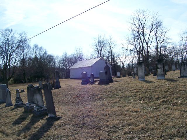
| Description | : | On the northeast corner of Tent Road (TR 439) and Tent Church Road (TR 346) just off SR 22 (Cincinnati-Zanesville Road) The cemetery is located in Pleasant Township, Fairfield County, Ohio, and is # 3246 (Tent Church Cemetery / Grace Cemetery) in “Ohio Cemeteries 1803-2003”, compiled by the Ohio Genealogical Society. The U.S. Geological Survey (USGS) Geographic Names Information System (GNIS) feature ID for the cemetery is 1040994 (Grace Cemetery / Grace Lutheran Cemetery). |
frequently asked questions (FAQ):
-
Where is Tent Church Cemetery?
Tent Church Cemetery is located at Tent Road NE Lancaster, Fairfield County ,Ohio , 43130USA.
-
Tent Church Cemetery cemetery's updated grave count on graveviews.com?
62 memorials
-
Where are the coordinates of the Tent Church Cemetery?
Latitude: 39.7485929
Longitude: -82.4819305

Nearby Cemetories:
1. Grace Evangelical Lutheran Church Cemetery
Lancaster, Fairfield County, USA
Coordinate: 39.7491330, -82.4894720
2. Saint Mathews Cemetery
Lancaster, Fairfield County, USA
Coordinate: 39.7461014, -82.5017014
3. Friend-Ruffner Cemetery
West Rushville, Fairfield County, USA
Coordinate: 39.7714005, -82.4728012
4. Baptist Corners Cemetery
Lancaster, Fairfield County, USA
Coordinate: 39.7732520, -82.5059350
5. Casper Hufford Cemetery
Lancaster, Fairfield County, USA
Coordinate: 39.7196198, -82.4976425
6. Amish Mennonite Cemetery
Lancaster, Fairfield County, USA
Coordinate: 39.7218610, -82.5035470
7. Bibler Cemetery
Fairfield County, USA
Coordinate: 39.7214012, -82.5081024
8. West Rushville Cemetery
West Rushville, Fairfield County, USA
Coordinate: 39.7644005, -82.4424973
9. Driver Cemetery
Bremen, Fairfield County, USA
Coordinate: 39.7144012, -82.4721985
10. Maple Grove Cemetery
Lancaster, Fairfield County, USA
Coordinate: 39.7266998, -82.5186005
11. Pleasant Hill United Methodist Cemetery
Pleasant Township, Fairfield County, USA
Coordinate: 39.7454830, -82.5303940
12. Mount Tabor Cemetery
Fairfield County, USA
Coordinate: 39.7205000, -82.5174330
13. Collins Chapel Cemetery
Fairfield County, USA
Coordinate: 39.7097015, -82.4961014
14. Friesner Cemetery
Lancaster, Fairfield County, USA
Coordinate: 39.7252998, -82.5258026
15. Stevenson Ruffner Cemetery
Richland Township, Fairfield County, USA
Coordinate: 39.7863998, -82.4582977
16. Mount Zion Cemetery
Bremen, Fairfield County, USA
Coordinate: 39.7075005, -82.4666977
17. Rushville Pleasant Hill Cemetery
Rushville, Fairfield County, USA
Coordinate: 39.7599983, -82.4278030
18. Kaufman-Valentine Cemetery
West Rushville, Fairfield County, USA
Coordinate: 39.7932050, -82.4650100
19. Kerlin - Morrow Cemetery
Rushville, Fairfield County, USA
Coordinate: 39.7727240, -82.4285320
20. Teel Cemetery
Pleasantville, Fairfield County, USA
Coordinate: 39.7961390, -82.4937630
21. Keller Cemetery
Fairfield County, USA
Coordinate: 39.7728060, -82.5377860
22. Emanuel Lutheran Church Cemetery
Lancaster, Fairfield County, USA
Coordinate: 39.7497128, -82.5490379
23. Winters Cemetery
Pleasantville, Fairfield County, USA
Coordinate: 39.7812260, -82.5382020
24. Applegate Cemetery
Lancaster, Fairfield County, USA
Coordinate: 39.7202988, -82.5421982