
| Memorials | : | 0 |
| Location | : | Old Sneedsboro, Anson County, USA |
| Coordinate | : | 34.8256300, -79.9365900 |
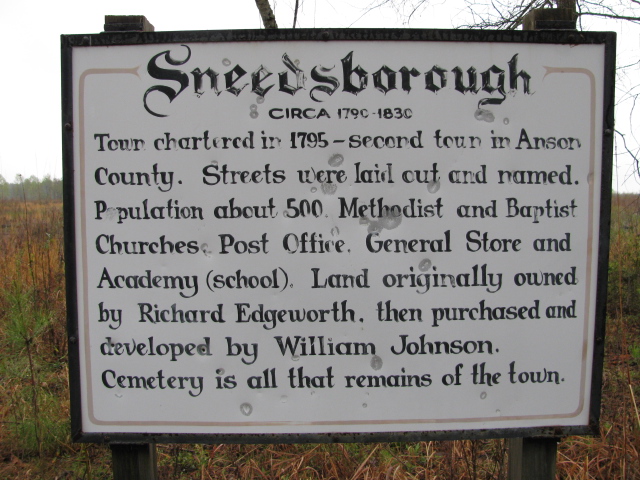
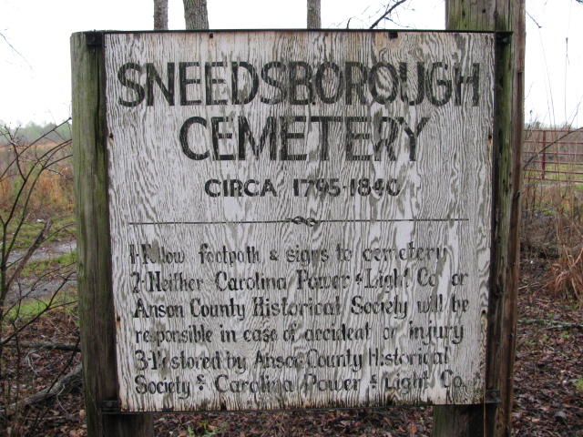
| Description | : | Take Highway 52 South from Wadesboro, North Carolina. Go through Morven to McFarlan, North Carolina. Turn left onto Sneedsborough Road. Go about two and one half miles. There is a Sneedsborough sign and a Sneedsborough Cemetery sign on the right. There is a locked gate. You will have to walk to the cemetery. It is about one quarter mile down the drive. |
frequently asked questions (FAQ):
-
Where is Sneedsborough Cemetery?
Sneedsborough Cemetery is located at Sneedsborough Road Old Sneedsboro, Anson County ,North Carolina ,USA.
-
Sneedsborough Cemetery cemetery's updated grave count on graveviews.com?
0 memorials
-
Where are the coordinates of the Sneedsborough Cemetery?
Latitude: 34.8256300
Longitude: -79.9365900
Nearby Cemetories:
1. Pleasant Hill Cemetery
McFarlan, Anson County, USA
Coordinate: 34.8161011, -79.9728012
2. Mount Zion United Methodist Church Cemetery
Cheraw, Chesterfield County, USA
Coordinate: 34.7972880, -79.9647960
3. New Hope United Methodist Church Cemetery
Wallace, Marlboro County, USA
Coordinate: 34.8040428, -79.8906174
4. Ramah Grove Missionary Baptist Church Cemetery
McFarlan, Anson County, USA
Coordinate: 34.8241437, -79.9897166
5. Jones-Hinson Family Cemetery
Chesterfield, Chesterfield County, USA
Coordinate: 34.7989860, -79.9805010
6. Thomas Ratliff Cemetery
Cairo, Anson County, USA
Coordinate: 34.8708450, -79.9166700
7. Martin Adams Cemetery
Cairo, Anson County, USA
Coordinate: 34.8797350, -79.9502560
8. Bethel United Methodist Church
Wallace, Marlboro County, USA
Coordinate: 34.7841300, -79.8903900
9. Old Scottish Cemetery
Morven, Anson County, USA
Coordinate: 34.8757920, -79.9746320
10. Shiloh United Methodist Church Cemetery
Cairo, Anson County, USA
Coordinate: 34.8853190, -79.9371730
11. Morven Cemetery
Morven, Anson County, USA
Coordinate: 34.8669800, -79.9931600
12. McLaurin Cemetery
Morven, Anson County, USA
Coordinate: 34.8363590, -80.0145810
13. McClain Grove Missionary Baptist Church Cemetery
Cheraw, Chesterfield County, USA
Coordinate: 34.7873270, -80.0011380
14. Flowers Family
Cairo, Anson County, USA
Coordinate: 34.8779040, -79.8860550
15. Short Family Cemetery
Chesterfield County, USA
Coordinate: 34.7931670, -80.0118550
16. Westfield Creek Baptist Church Cemetery
Chesterfield County, USA
Coordinate: 34.7888985, -80.0108032
17. Pittman Cemetery
Morven, Anson County, USA
Coordinate: 34.8362360, -80.0242320
18. Saint Stephen's Missionary Baptist Church Cemetery
Rockingham, Richmond County, USA
Coordinate: 34.8302000, -79.8455300
19. Covington Cemetery
Morven, Anson County, USA
Coordinate: 34.8827010, -79.9988790
20. Brock Family Cemetery
Brocks Mill, Chesterfield County, USA
Coordinate: 34.7627750, -79.9916350
21. Saint Stephen's Cemetery
Rockingham, Richmond County, USA
Coordinate: 34.8232994, -79.8419037
22. Lebanon Presbyterian Church Cemetery
Morven, Anson County, USA
Coordinate: 34.8645770, -80.0233200
23. Brocks Mill Baptist Church Cemetery
Chesterfield, Chesterfield County, USA
Coordinate: 34.7582730, -79.9917660
24. Brocks Mill Baptist Church Cemetery Annex
Brocks Mill, Chesterfield County, USA
Coordinate: 34.7578990, -79.9919590