
| Memorials | : | 0 |
| Location | : | Brocks Mill, Chesterfield County, USA |
| Coordinate | : | 34.7578990, -79.9919590 |
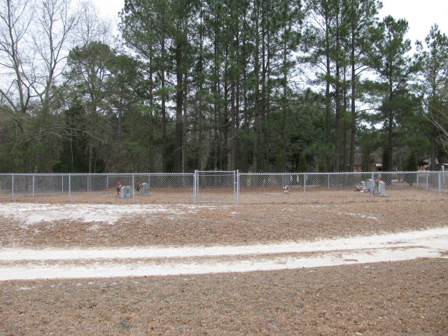
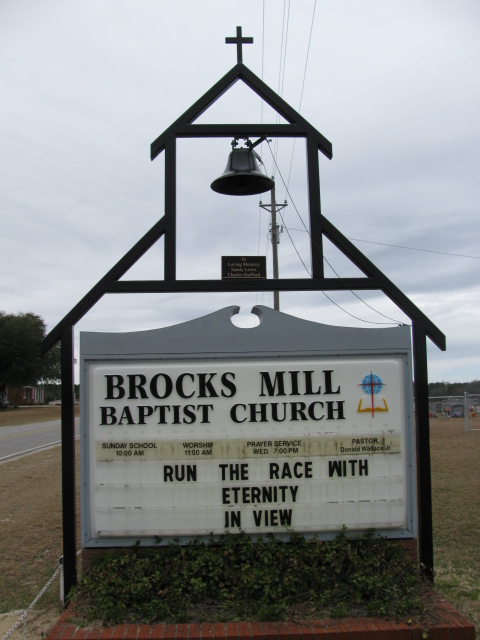
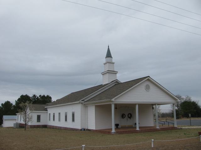
| Description | : | Mailing and Physical Address: Brocks Mill Baptist Church 4218 Brocks Mill Road Chesterfield, SC 29709 Telephone: 843-623-6523 Directions: From Chesterfield take Highway 9 East to Zoar Road on the left. Turn left onto Zoar Road and travel approximately 4 miles to insection with Brocks Mill Road. Turn right onto Brocks Mill Road and travel approximately 3 miles to Brocks Mill Church. This cemetery is across the road from the church and current cemetery. |
frequently asked questions (FAQ):
-
Where is Brocks Mill Baptist Church Cemetery Annex?
Brocks Mill Baptist Church Cemetery Annex is located at Brocks Mill, Chesterfield County ,South Carolina ,USA.
-
Brocks Mill Baptist Church Cemetery Annex cemetery's updated grave count on graveviews.com?
0 memorials
-
Where are the coordinates of the Brocks Mill Baptist Church Cemetery Annex?
Latitude: 34.7578990
Longitude: -79.9919590
Nearby Cemetories:
1. Brocks Mill Baptist Church Cemetery
Chesterfield, Chesterfield County, USA
Coordinate: 34.7582730, -79.9917660
2. Brock Family Cemetery
Brocks Mill, Chesterfield County, USA
Coordinate: 34.7627750, -79.9916350
3. Sellers Cemetery
Brocks Mill, Chesterfield County, USA
Coordinate: 34.7604070, -79.9992870
4. Brock Cemetery
Brocks Mill, Chesterfield County, USA
Coordinate: 34.7503930, -79.9863370
5. Pleasant Grove AME Zion Church Cemetery
Chesterfield, Chesterfield County, USA
Coordinate: 34.7587490, -80.0172040
6. Zoar United Methodist Church Cemetery
Brocks Mill, Chesterfield County, USA
Coordinate: 34.7648277, -80.0217819
7. Privett Family Cemetery
Chesterfield, Chesterfield County, USA
Coordinate: 34.7658230, -80.0220910
8. McClain Grove Missionary Baptist Church Cemetery
Cheraw, Chesterfield County, USA
Coordinate: 34.7873270, -80.0011380
9. Westfield Creek Baptist Church Cemetery
Chesterfield County, USA
Coordinate: 34.7888985, -80.0108032
10. Short Family Cemetery
Chesterfield County, USA
Coordinate: 34.7931670, -80.0118550
11. Midway Baptist Church Cemetery
Cheraw, Chesterfield County, USA
Coordinate: 34.7170570, -79.9826580
12. Jones-Hinson Family Cemetery
Chesterfield, Chesterfield County, USA
Coordinate: 34.7989860, -79.9805010
13. Saint Josephs Cemetery
Cheraw, Chesterfield County, USA
Coordinate: 34.7175410, -79.9702010
14. Teal Family Cemetery
Chesterfield, Chesterfield County, USA
Coordinate: 34.7583530, -80.0463330
15. Davis Cemetery
Chesterfield, Chesterfield County, USA
Coordinate: 34.7676600, -80.0456570
16. Mount Zion United Methodist Church Cemetery
Cheraw, Chesterfield County, USA
Coordinate: 34.7972880, -79.9647960
17. Southern Grace Church
Chesterfield, Chesterfield County, USA
Coordinate: 34.7234820, -80.0300720
18. Rivers Cemetery
Chesterfield, Chesterfield County, USA
Coordinate: 34.7433100, -80.0484090
19. Saint Paul Missionary Baptist Church
Cheraw, Chesterfield County, USA
Coordinate: 34.7109260, -79.9745410
20. Confederate Soldier Burial Ground
Chesterfield, Chesterfield County, USA
Coordinate: 34.7300670, -80.0416230
21. Rivers Family Cemetery
Chesterfield, Chesterfield County, USA
Coordinate: 34.7484950, -80.0539370
22. Goodman Creek Missionary Baptist Church
Cheraw, Chesterfield County, USA
Coordinate: 34.7356390, -79.9347530
23. Pine Grove Baptist Church Cemetery
Chesterfield County, USA
Coordinate: 34.7366982, -80.0500031
24. Robinson Zion Church
Cheraw, Chesterfield County, USA
Coordinate: 34.7328090, -79.9323420