
| Memorials | : | 1 |
| Location | : | Kidron, Wayne County, USA |
| Coordinate | : | 40.7600010, -81.7210720 |
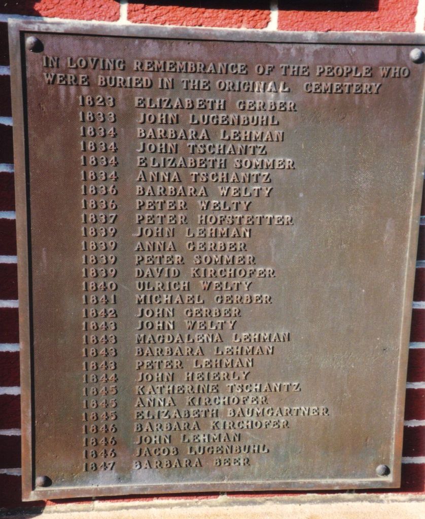
| Description | : | This cemetery is on private property north of Hackett Road northeast of Kidron, Ohio. There a very few stones still existing in this cemetery, and its exact location is being researched by the Kidron Community Historical Society. A marker listing the persons known to be buried in this cemetery is located on the grounds of the Sonnenberg Mennonite Church on Hackett Road. |
frequently asked questions (FAQ):
-
Where is Sonnenberg Pioneer Cemetery?
Sonnenberg Pioneer Cemetery is located at Kidron, Wayne County ,Ohio ,USA.
-
Sonnenberg Pioneer Cemetery cemetery's updated grave count on graveviews.com?
1 memorials
-
Where are the coordinates of the Sonnenberg Pioneer Cemetery?
Latitude: 40.7600010
Longitude: -81.7210720


Nearby Cemetories:
1. Sonnenberg Mennonite Cemetery
Kidron, Wayne County, USA
Coordinate: 40.7561989, -81.7267990
2. Salem Mennonite Church Cemetery
Kidron, Wayne County, USA
Coordinate: 40.7589989, -81.7321014
3. Kidron Mennonite Church Cemetery
Kidron, Wayne County, USA
Coordinate: 40.7507019, -81.7462997
4. Bethel Mennonite Cemetery
Riceland, Wayne County, USA
Coordinate: 40.7784004, -81.7465973
5. Arnold Cemetery
Kidron, Wayne County, USA
Coordinate: 40.7853012, -81.7335968
6. New Life Chapel Cemetery
Dalton, Wayne County, USA
Coordinate: 40.7626200, -81.6680700
7. Pleasant Valley Cemetery
Wayne County, USA
Coordinate: 40.7622986, -81.6677017
8. Dalton Cemetery
Dalton, Wayne County, USA
Coordinate: 40.7972500, -81.6987500
9. Joe Zook Cemetery
Mount Eaton, Wayne County, USA
Coordinate: 40.7190580, -81.7214860
10. Aaron Troyer Cemetery
East Union Township, Wayne County, USA
Coordinate: 40.7667520, -81.7788700
11. Rock of Ages Church of God in Christ Cemetery
Apple Creek, Wayne County, USA
Coordinate: 40.7450710, -81.7764900
12. Ananias Hershberger Farm Cemetery
West Lebanon, Wayne County, USA
Coordinate: 40.7350190, -81.6700240
13. Joe Yoder Cemetery
Kidron, Wayne County, USA
Coordinate: 40.7326860, -81.7749100
14. West Lebanon Union Cemetery
West Lebanon, Wayne County, USA
Coordinate: 40.7262170, -81.6736130
15. Sugar Creek Township Cemetery
West Lebanon, Wayne County, USA
Coordinate: 40.7294998, -81.6688004
16. West Lebanon Lutheran Cemetery
West Lebanon, Wayne County, USA
Coordinate: 40.7258987, -81.6653976
17. Carr Cemetery
Riceland, Wayne County, USA
Coordinate: 40.7965870, -81.7843170
18. East Union Mennonite Church Cemetery
Orrville, Wayne County, USA
Coordinate: 40.7969820, -81.7865610
19. Martins Mennonite Cemetery
Orrville, Wayne County, USA
Coordinate: 40.8214989, -81.7323990
20. Van Kirk Cemetery
Orrville, Wayne County, USA
Coordinate: 40.8222008, -81.7399979
21. Fountain Hill Cemetery
Wayne County, USA
Coordinate: 40.8011017, -81.7855988
22. Hershberger Cemetery
Mount Eaton, Wayne County, USA
Coordinate: 40.6968994, -81.7367020
23. Westlawn Cemetery
Mount Eaton, Wayne County, USA
Coordinate: 40.6973000, -81.7026978
24. Red Run Cemetery
Apple Creek, Wayne County, USA
Coordinate: 40.7290001, -81.7966003