
| Memorials | : | 0 |
| Location | : | Droitwich Spa, Wychavon District, England |
| Coordinate | : | 52.2683700, -2.1486900 |
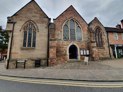
| Description | : | St Andrew’s St Andrew’s Church, which stands on the corner of Droitwich High Street and St Andrew’s Street, is opposite the old town hall, although its dominant position in the town centre has now been largely obscured by the number of buildings around it. A new walkway and marketplace leading from the Waitrose car-park into the High Street has helped restore its visibility, and we hope it will have a part to play in the regeneration of this oldest part of our town. st_andrewsParts of the building are Norman, and it is most likely the church in which St Richard was baptised... Read More |
frequently asked questions (FAQ):
-
Where is St Andrew's Church?
St Andrew's Church is located at St Andrew's Street Droitwich Spa, Wychavon District ,Worcestershire , WR9 8DYEngland.
-
St Andrew's Church cemetery's updated grave count on graveviews.com?
0 memorials
-
Where are the coordinates of the St Andrew's Church?
Latitude: 52.2683700
Longitude: -2.1486900
Nearby Cemetories:
1. St. Augustine Churchyard
Droitwich Spa, Wychavon District, England
Coordinate: 52.2709800, -2.1457700
2. St. Mary's Churchyard
Droitwich Spa, Wychavon District, England
Coordinate: 52.2637900, -2.1505600
3. St Nicholas Churchyard
Droitwich Spa, Wychavon District, England
Coordinate: 52.2676400, -2.1573700
4. St Peters Churchyard
Droitwich Spa, Wychavon District, England
Coordinate: 52.2605200, -2.1446400
5. Sacred Heart & Saint Catherine Churchyard
Droitwich Spa, Wychavon District, England
Coordinate: 52.2588639, -2.1551795
6. St. Richard & St. Hubert Churchyard
Hadzor, Wychavon District, England
Coordinate: 52.2590340, -2.1279577
7. St John the Baptist Churchyard
Hadzor, Wychavon District, England
Coordinate: 52.2612700, -2.1253600
8. St. Mary & All Saints Churchyard
Hampton Lovett, Wychavon District, England
Coordinate: 52.2885000, -2.1641400
9. St. Michael's Churchyard
Salwarpe, Wychavon District, England
Coordinate: 52.2567600, -2.1850900
10. St. Mary de Wyche Churchyard
Wychbold, Wychavon District, England
Coordinate: 52.2910500, -2.1047300
11. St Michael and All Angels Churchyard
Martin Hussingtree, Wychavon District, England
Coordinate: 52.2364000, -2.1819030
12. St. Mary's Churchyard
Elmbridge, Wychavon District, England
Coordinate: 52.3088400, -2.1490800
13. St James Churchyard
Oddingley, Wychavon District, England
Coordinate: 52.2295031, -2.1265901
14. St. Mary's Churchyard
Doverdale, Wychavon District, England
Coordinate: 52.2922300, -2.2064500
15. St. James Churchyard
Hindlip, Wychavon District, England
Coordinate: 52.2254059, -2.1767057
16. St. Michael's Churchyard
Upton Warren, Wychavon District, England
Coordinate: 52.3053500, -2.1030600
17. St Andrews Churchyard
Ombersley, Wychavon District, England
Coordinate: 52.2699600, -2.2294600
18. St. Mary the Virgin Churchyard
Hanbury, Wychavon District, England
Coordinate: 52.2772778, -2.0684032
19. Spellis Green Burial Ground
Fernhill Heath, Wychavon District, England
Coordinate: 52.2257240, -2.1949210
20. St Peter ad Vincula Churchyard
Tibberton, Wychavon District, England
Coordinate: 52.2109700, -2.1444900
21. St. Mary Magdalene Churchyard
Himbleton, Wychavon District, England
Coordinate: 52.2270000, -2.0796300
22. St Nicholas Churchyard
Warndon, City of Worcester, England
Coordinate: 52.2100577, -2.1657159
23. St. John the Baptist Churchyard
Claines, Wychavon District, England
Coordinate: 52.2273145, -2.2184514
24. St. Michaels & All Angels Churchyard
Stoke Prior, Bromsgrove District, England
Coordinate: 52.3073925, -2.0757422