
| Memorials | : | 5 |
| Location | : | Cranmore, Mendip District, England |
| Coordinate | : | 51.1882670, -2.4760330 |
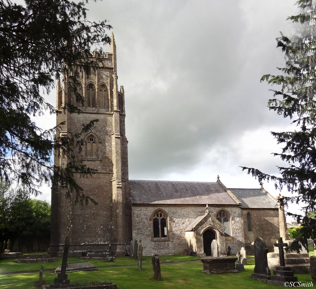
| Description | : | The Anglican Church of St Bartholomew in Cranmore, Somerset, England, dates from the 15th century and has been designated as a Grade I listed building. The chancel was rebuilt in 1848 in a perpendicular early English style. It has a three-stage embattled tower, supported by buttresses with corner pinnacles, tracery and gargoyles. There is a stone fan vault under the tower. [text by SCSmith ] |
frequently asked questions (FAQ):
-
Where is St Bartholomew Churchyard?
St Bartholomew Churchyard is located at Cooks Lane Cranmore, Mendip District ,Somerset , BA4 4QJEngland.
-
St Bartholomew Churchyard cemetery's updated grave count on graveviews.com?
5 memorials
-
Where are the coordinates of the St Bartholomew Churchyard?
Latitude: 51.1882670
Longitude: -2.4760330
Nearby Cemetories:
1. Saint Bartholomew Chapel Churchyard
Cranmore, Mendip District, England
Coordinate: 51.1882990, -2.4759150
2. St. Aldhelm Churchyard
Doulting, Mendip District, England
Coordinate: 51.1862880, -2.5077290
3. St Mary's, Chesterblade
Evercreech, Mendip District, England
Coordinate: 51.1692610, -2.4861180
4. St Michael & All Angels
Stoke St Michael, Mendip District, England
Coordinate: 51.2208300, -2.4819900
5. The Blessed Virgin Mary Churchyard
Wanstrow, Mendip District, England
Coordinate: 51.1735190, -2.4164890
6. Saint Giles Churchyard
Leigh-on-Mendip, Mendip District, England
Coordinate: 51.2239000, -2.4416000
7. St Peter and St Paul Church
Shepton Mallet, Mendip District, England
Coordinate: 51.1908700, -2.5454300
8. Saint Mary The Virgin
Batcombe, Mendip District, England
Coordinate: 51.1495900, -2.4433900
9. Evercreech Cemetery
Evercreech, Mendip District, England
Coordinate: 51.1461300, -2.4989500
10. St Peter Churchyard
Evercreech, Mendip District, England
Coordinate: 51.1462670, -2.5025440
11. Shepton Mallet Cemetery
Shepton Mallet, Mendip District, England
Coordinate: 51.1948900, -2.5483390
12. St James Church
Milton Clevedon, Mendip District, England
Coordinate: 51.1381600, -2.4809000
13. St. Mary's Churchyard
Mendip District, England
Coordinate: 51.1942400, -2.3928700
14. St James Churchyard
Ashwick, Mendip District, England
Coordinate: 51.2320800, -2.5229500
15. Holy Trinity Churchyard
Coleford, Mendip District, England
Coordinate: 51.2394100, -2.4503100
16. St Edmund's Church Vobster
Mells, Mendip District, England
Coordinate: 51.2418000, -2.4244930
17. Mendip crematorium
Mendip District, England
Coordinate: 51.1911487, -2.5797562
18. All Saints Churchyard
Nunney, Mendip District, England
Coordinate: 51.2098694, -2.3772340
19. St. Andrew's Churchyard
Holcombe, Mendip District, England
Coordinate: 51.2547850, -2.4760280
20. Downside Abbey
Stratton-on-the-Fosse, Mendip District, England
Coordinate: 51.2544000, -2.4943000
21. Saint Vigor Churchyard
Stratton-on-the-Fosse, Mendip District, England
Coordinate: 51.2552000, -2.4896000
22. Christ Church Churchyard
Mendip District, England
Coordinate: 51.2514920, -2.5151540
23. Christ Church, Downside
Chilcompton, Mendip District, England
Coordinate: 51.2515150, -2.5153030
24. Byfields Cemetery
Nunney, Mendip District, England
Coordinate: 51.2077210, -2.3722630